Here's what I saw on my tour of the CTIA exhibition
floor.
"Meaty Stuff"
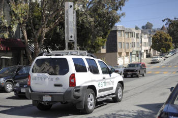
earthmine, an application that looks like a combination of Google StreetView, Immersive Media and LiDAR technology, is collecting true stereo, 3D images that can be integrated with any GIS. earthmine has a vehicle that drives the streets collecting street-level data. The idea is that accurate measurements can be taken directly from the street view image, similar to what you might expect from close range photogrammetry. Applications could be numerous, from city government to inventory assets to emergency management that needs accurate information about building position, height and distance from other assets.
INRIX has been approached by a hedge
fund to use the company's data to predict the economic viability of an
area. The hedge fund's management believes that an indicator of
economic health is the level of traffic served by highways.
"Consumer Gnash"
adNav is partnering with Omni Hotels to launch an application for the savvy traveler. When a visitor checks into the hotel, he will receive a portable handset that becomes a personal concierge. It contains a city guide, personal navigation device, flight tracker and a few other applications. The handset is GPS equipped and is the size of a typical PDA. The traveler returns the unit at the end of his stay. Getzy Fellig, president and founder of adNav, believes this device provides a unique service. A traveler will not have to worry about planning the trip; he'll get all the information he needs via the handset. It is a partnership that allows the hotel to provide a higher level of service. This is an advertising-based business model, and adNav seeks other partners in the travel industry to target the advertising within local areas.
Wavemarket is delivering Family Finder and Asset Tracker applications to carriers. The company recently announced a deal with Aliant, a Canadian communications provider. Wavemarket CEO Tasso Roumeloitus told me the company wants to remain focused on these two applications. Wavemarket also utilizes its applications to support a large effort with the AmberWatch Foundation.
Hollywood USA thinks there is a market for a points of interests (POI) database of movie locations. Curious as to which movies were filmed on location in a specific area? Go to www.hollywood-USA.mobi.
"Software Developer Dish"
Hitachi is launching an embeddable relational database for mobile handsets called Entier that is spatially enabled. Hitachi says its database is compact and fast enough to enable more robust searches on data stored locally on “converged mobile devices.” So, whether you are doing a local search for POIs or a search of music files of a particular genre, the database is configured to give you an easy way to retrieve files. The database is SQL92 compliant, has a footprint of 500-700Kb and uses a B-tree index search, as well as spatial queries. Hitachi is seeking developers to use the technology.
Traffic.com is offering TrafficOne Mobile, a solution for mobile phones, to application developers because it offers a series of application interfaces and "flexible revenue" options.
Geomicro is touting its developer interface for fleet applications. Geomicro is trying to stay above the fray in the consumer space.
"What's cookin' ... for now" - Social networking
Qualcomm is pushing the gpsOne solution for CDMA phones. The company claims to have enabled 300 million mobile devices with gpsOne technology and was demonstrating social networking applications with partners.
Socialight just launched a location-aware application in London. Users will simply text a word to a shortcode, 88811, to receive “hyperlocal” content.
Summary
Location technology was a hot topic at CTIA. Most of the largest mobile technology providers were demonstrating some application of local mobile search with a map metaphor. It seems finally to have reached a critical mass of adoption, but at this point only navigation or friend/family finder apps will be offered by carriers. Other types of location-based services have yet to be offered because carriers have yet to embrace a business model that will bring them the revenue they expect. That will come, but for now the carriers are the gatekeepers. You can expect, however, the carriers to be heavily pushed by device manufacturers that are equipping their units with GPS chipsets to ensure that LBS apps can be readily enabled. All you have to do is look at the pending NAVTEQ acquisition by Nokia to see how that scenario
"Meaty Stuff"
earthmine, an application that looks like a combination of Google StreetView, Immersive Media and LiDAR technology, is collecting true stereo, 3D images that can be integrated with any GIS. earthmine has a vehicle that drives the streets collecting street-level data. The idea is that accurate measurements can be taken directly from the street view image, similar to what you might expect from close range photogrammetry. Applications could be numerous, from city government to inventory assets to emergency management that needs accurate information about building position, height and distance from other assets.
 |
"Consumer Gnash"
adNav is partnering with Omni Hotels to launch an application for the savvy traveler. When a visitor checks into the hotel, he will receive a portable handset that becomes a personal concierge. It contains a city guide, personal navigation device, flight tracker and a few other applications. The handset is GPS equipped and is the size of a typical PDA. The traveler returns the unit at the end of his stay. Getzy Fellig, president and founder of adNav, believes this device provides a unique service. A traveler will not have to worry about planning the trip; he'll get all the information he needs via the handset. It is a partnership that allows the hotel to provide a higher level of service. This is an advertising-based business model, and adNav seeks other partners in the travel industry to target the advertising within local areas.
 |
Wavemarket is delivering Family Finder and Asset Tracker applications to carriers. The company recently announced a deal with Aliant, a Canadian communications provider. Wavemarket CEO Tasso Roumeloitus told me the company wants to remain focused on these two applications. Wavemarket also utilizes its applications to support a large effort with the AmberWatch Foundation.
Hollywood USA thinks there is a market for a points of interests (POI) database of movie locations. Curious as to which movies were filmed on location in a specific area? Go to www.hollywood-USA.mobi.
"Software Developer Dish"
Hitachi is launching an embeddable relational database for mobile handsets called Entier that is spatially enabled. Hitachi says its database is compact and fast enough to enable more robust searches on data stored locally on “converged mobile devices.” So, whether you are doing a local search for POIs or a search of music files of a particular genre, the database is configured to give you an easy way to retrieve files. The database is SQL92 compliant, has a footprint of 500-700Kb and uses a B-tree index search, as well as spatial queries. Hitachi is seeking developers to use the technology.
Traffic.com is offering TrafficOne Mobile, a solution for mobile phones, to application developers because it offers a series of application interfaces and "flexible revenue" options.
Geomicro is touting its developer interface for fleet applications. Geomicro is trying to stay above the fray in the consumer space.
 |
"What's cookin' ... for now" - Social networking
Qualcomm is pushing the gpsOne solution for CDMA phones. The company claims to have enabled 300 million mobile devices with gpsOne technology and was demonstrating social networking applications with partners.
Socialight just launched a location-aware application in London. Users will simply text a word to a shortcode, 88811, to receive “hyperlocal” content.
Summary
Location technology was a hot topic at CTIA. Most of the largest mobile technology providers were demonstrating some application of local mobile search with a map metaphor. It seems finally to have reached a critical mass of adoption, but at this point only navigation or friend/family finder apps will be offered by carriers. Other types of location-based services have yet to be offered because carriers have yet to embrace a business model that will bring them the revenue they expect. That will come, but for now the carriers are the gatekeepers. You can expect, however, the carriers to be heavily pushed by device manufacturers that are equipping their units with GPS chipsets to ensure that LBS apps can be readily enabled. All you have to do is look at the pending NAVTEQ acquisition by Nokia to see how that scenario
From Our Homepage
Saying Farewell to an Amazing Journey
Communicating with Maps
Is There a GIS Career Ladder?
What does it mean to be geospatially smart? Series
Ways Real Estate and Property Developers Utilize Melissa GeoData for Data-Driven Decisions
Unlocking Value From Daily Satellite Imagery and Insights
Maximizing the Value of Your Address Data with Geo Addressing
How Indoor Mapping Enhances the Security of Smart Buildings
Look Ahead: AI, Location Intelligence and Efficiency
Collaboration Takes on Sea Level Rise & Dynamic Technology Environments
Brownies for Brownfields
Has Everything Been Mapped Already?
How Is Data Literacy Changing in an Artificial Intelligence Landscape
Portfolios for GIS Professionals: More Than Just Maps
How to Create a Distance Matrix in QGIS - A Step-by-Step Guide
7 Ideas for Bringing GIS into the K-12 Classroom
The Geography of Movement