Lawrence Faulkner's 3-D models are an instrumental part of the team fighting forest fires this fall in Southern California.How they got there, and what Lawrence can do with the output of mapping software, is an interesting tale.
Ten years ago Lawrence Faulkner was an estimator for a heavy earth moving contractor.His job was to judge how much dirt would have to be moved on a given project.His company was pretty proud of the clever little tool - called a planimeter - that you could roll around on the job map to determine the area of irregular polygons.But Lawrence thought he could develop something better, and his Odyssey began there.
Within months, Mr.Faulkner had developed software that allowed the digitization of existing topography and finished grade points (x and y axis) with this planimeter.These points (10,000 for a grading plan) were fed to a software package called Surfer (from Golden Software); once Surfer had these points, it could do precise volume calculations.More importantly, these results were reproducible.Lawrence was a hit at his firm; but not a satisfied man.The models were derived, but then lost; rendering was expensive, slow, and restricted to one view.He started to think about a machine ...
 Lawrence Faulkner
With a hobby kit and a step motor controller, his experiment proceeded.Chips to control the motor turned out to be available at a hobby shop for $1.50 each.Faulkner found he needed six bits to control three axes of motion.He built the logic array to do that with discrete components.Eventually, Lawrence had written a program to sequence 3 motors, producing coordinated motion.On to hardware.
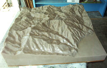
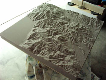
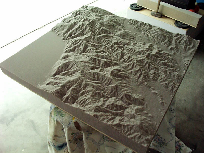
Faulkner bought hollow core doors from Home Depot as a base.He took the lead screw followers he'd obtained from a garage door fix-it man and attached them to cast carriages.The resulting "machine" carves 3-D models from styrofoam much like a plotter prints; the foam moves in the x-axis, the cutter in the y- and z-axes.
By 1993 the machine was cutting 3-D models (really 2 1/2-D; Faulkner's device can not cut holes underneath a surface).His first commercial customer was a developer denied a city permit; Faulkner's 3-D rendering proved the developer's case.His pay: $250 and a rug.Faulkner hand-digitized the data for this first job.
Since then, Faulkner has developed a system for translating GIS and CAD data from their native formats, using TerraModel software from Spectra Precision.
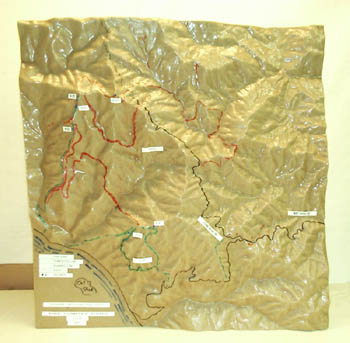
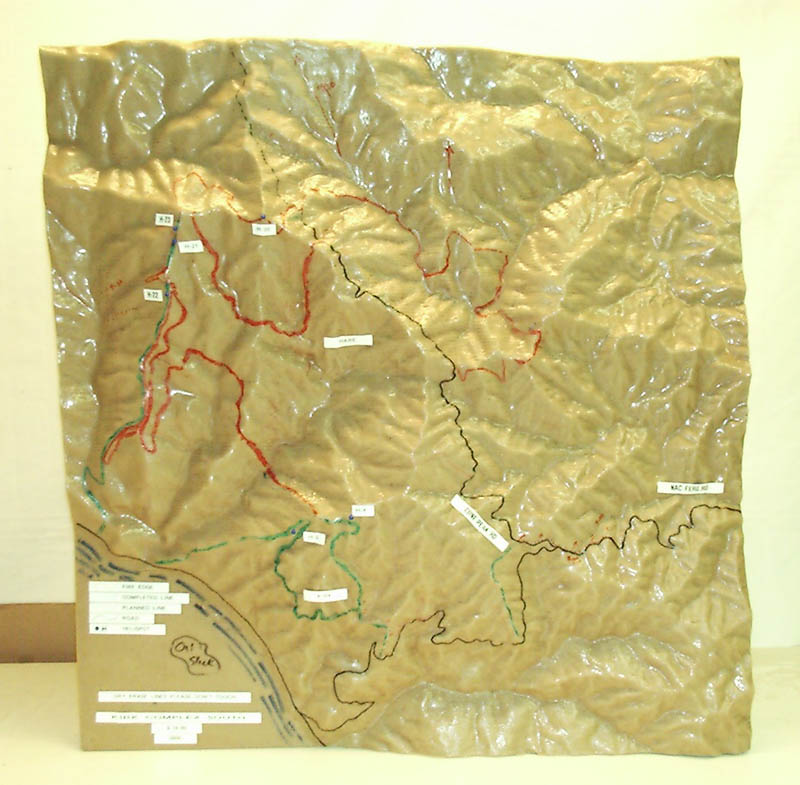
Client costs for Faulkner's models are typically around $1,000, with 24-hour turnaround possible.The models measure 36" square on the side.The biggest (largest scale) model he's done is of 26 square miles, and was used to fight a fire in Monterey.The models are cut into foam, and then coated with fiberglass resin.Customers can then write on the models with permanent or dry-erase inks.
Mr.Faulkner has no plans at present to manufacture his "contraption" for sale.His interest has primarily been to demonstrate the applicability of solid 3-D modeling to CAD and GIS.
Recently Faulkner's happiest clients have been U.S.Forest Service firefighters in Southern California.His models have been instrumental in planning fire-fighting tactics, and have been featured on local news outlets.He envisions the day when firefighters will inventory 3-D models of all the terrain for which they're responsible.At present, they fax him a map with the area about which they're concerned circled in red; Faulkner orders the corresponding digital 7-1/2 minute DEM from the USGS, and produces the appropriate 3-D model.
In another life, Faulkner is the Executive Director of the Infrared Data Association, an organization tasked with defining communication protocols for infrared devices.
Faulkner's current efforts are devoted to perfecting a process for laying photographic images atop his models.He treats the foam models with a photosensitive solution, then exposes the negative in a darkroom.
In Lawrence Faulkner's view, the "convergence of GIS efforts provide a perfect environment for the acceptance of solid 3-D modeling.Data is now all digital in standard formats; 99% of the work (data collection) has been done."
Faulkner's 3-D output has been used in emergency management, search & rescue, fire, municipal planning, and legal settings.Until this past year, half of his work was for courts, half for civil engineering applications.In his mind, the big potential is in public land management.
Email: Lawrence Faulkner
URL: Solid Terrain Modeling