There is something of importance happening to spatial data in the European Union (EU). It revolves around the Infrastructure for Spatial Information in Europe (INSPIRE), data quality and the development of a knowledge economy. INSPIRE is a large-scale engineering project that by law involves every European Member State. Driven forward after other public sector data initiatives, the INSPIRE directive (2007/2/EC) has created the basis for knowledge to be shared. Article 17 states:
"Each Member State shall adopt measures for the sharing of spatial data sets between its public authorities…for the purposes of public tasks that may have an impact on the environment."
It is the last word that is important in the global context because the directive is about sharing and reusing spatial data for the efficient consumption of resources. Sharing infrastructure resources across nation state boundaries can be the basis for reducing the carbon footprint of the EU. INSPIRE contains 34 spatial datasets which are the basis for spatial data sharing. Article 6 states that metadata will be shared two years after the adoption of the Implementing Rules1. This is now close at hand after significant effort has been expended across Europe with many parties working on rich data models across the nine Annex I reference geographies in the table below.
| Number | Theme Name |
| 1 | Co-ordinate Reference Systems |
| 2 | Geographical Grid Systems |
| 3 | Geographical Names |
| 4 | Administrative Units |
| 5 | Addresses |
| 6 | Cadastral Parcels |
| 7 | Transport Networks |
| 8 | Hydrography |
| 9 | Protected Sites |
The metadata includes information on data quality (1Spatial's core proposition) and the organizations responsible for providing the data. One can gain an insight into the volume of work undertaken, since some 176 Legally Mandated Organizations (LMOs) were nominated across Europe (by August 2009) as legally mandated data providers for INSPIRE purposes. The UK has just published a list of responsible organizations for its data provision under INSPIRE.
An example shows the significance of the effort being expended. An examination of the Cadastral Parcels data theme, one of the Annex I core reference geographies, demonstrates how significant the contributions are. In excess of 40 contributors across Europe have worked on this one theme alone. The scope of the Cadastral Parcels theme does not include property rights and ownership, but does include seven object classes and takes into account the 11 ISO standards and the OGC Simple Feature Access architecture. Quality is also an important component of the theme. The data quality elements relevant to Cadastral Parcels are specified in terms of Completeness and Positional Accuracy. The INSPIRE recommendation on quality states: Aggregated data quality information should ideally be collected at the level of spatial object types and included in the dataset (series) metadata.
Throughout Europe many of the Spatial Data Infrastructure (SDI) activities are linked with areas like Public Sector Information (PSI) reuse and the INSPIRE Directive. The main issue confronted by the LMOs is accommodating the additional work necessitated by supplying conformant data and managing the lifecycle of updates. In normal circumstances additional funding would be made available; these are not normal times. The transformation and reporting of metadata against the rich data schemas of INSPIRE and reporting of metadata needs to be automated. This is because many of the activities are manual, for example users sitting matching classes and attributes in the source schema against the target schema. The source schemas are typically flat file or relational and the target schema are object oriented, so it is not a simple one-to-one match in some of the cases. This adds even more cost since it is labor intensive and must be done each time. Once an investment has been made to automate the process, the transformation process will be improved and time and costs reduced. The goal is to maximize automation, therefore, to ensure that the task becomes achievable given the resource constraints. Maximizing the automation of this process is important because the aim of INSPIRE is to ensure that data are referenced, managed and therefore interoperable. This is the baseline for each theme. The data for building applications require further schema building on top of this baseline.
A number of projects are underway in Europe to produce best practice around SDIs and INSPIRE. These are now described below.
One project, the ESDIN eContentplus project, co-funded by the European Union and managed by EuroGeographics (a not-for-profit organization formed in 2001 as the membership association and representative body of the European national mapping, land registry and cadastral agencies), sets out to tackle practical elements of INSPIRE. Its long-term objective is to automate the production cycle for the 1:250k and 1:1m scale products (known as EuroMaps). ESDIN addresses the INSPIRE challenges by testing the theory of integrating National SDIs (NSDIs) to provide Europe with a framework of geographic reference information, or in other words, a European Spatial Data Infrastructure for which INSPIRE is the legal instrument. The funding (multi-millions of Euros) for this project was awarded in 2008 and there are 19 project members from more than 10 countries; 1Spatial is a key technology provider.
Working in harmony with national mapping and cadastre agencies in ESDIN, as well as some academic organizations, 1Spatial is addressing some long-standing industry problems, such as data consistency and integrity, by looking at possibilities for online data quality validation. 1Spatial is also looking into some specific data maintenance topics of interest to data providers, such as cross-border data consistency methodologies for edge-matched maintenance, which is important for combining spatial data of adjacent regions from different sources seamlessly. Other areas include:
- Stable Unique Identifiers (UIDs); workable at a European level in a data maintenance framework for regional or national data holdings
- incremental update deliveries at a European level; assessing methodologies and best practice for change-only updates
ESDIN will also help Member States, candidate countries and EFTA States (European Free Trade Association) to prepare their data (and maintenance processes) for INSPIRE Annex I data themes and improve access to them. This will ascertain if users can access and share geospatially referenced data for a variety of data themes at a European or local level.
A second, shorter project covers INSPIRE transformation services best practice. The SDI Unit at the Institute for the Environment and Sustainability at the European Commission's Joint Research Centre (JRC) in Italy coordinates the scientific and technical development of INSPIRE. It supports its implementation within the Commission and the Member States, evaluates its social and economic impacts, and leads the research effort toward "Next Generation Digital Earth," exploring new approaches for creating and sharing of environmental information.
The SDI Unit at the JRC is the largest group in Europe dedicated to SDI research and implementation in support of relevant EU policies. 1Spatial is part of a consortium, led by RSW Geomatics and in conjunction with Rob Walker Consultancy, that has been awarded a contract by the European Commission to provide technical guidance to the JRC for INSPIRE transformation services (using services to make spatial data sets conform to INSPIRE), specifically for schema transformation of geospatial datasets in Europe. Transformation is the key to achieving INSPIRE interoperability and effective data reuse. Quality controlled processes are essential to ensure large volumes of data are managed efficiently and consistently (see conceptual framework in figure below).
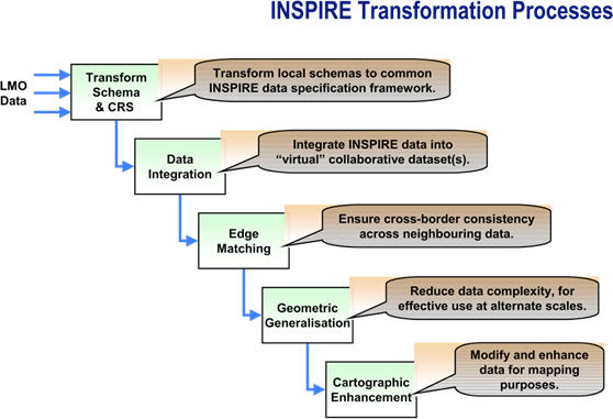 |
With so many regional and national SDIs at different points of development across Europe (and other geographical regions), data vary quite significantly in quality, coverage, content and structure. Pulling data together or aggregating them across Europe from the different sources, different themes and at multiple resolutions, through a services-based approach, is a concept yet to be implemented in practice on any significant scale. This contract award will go part of the way toward delivering the information required to better understand some of the benefits from data sharing and the harmonization challenges that schema transformation addresses.
This contract will be a major contribution to the European geospatial community, effectively delivering the necessary technical guidance to help institutions in European Member States to put into operation transformation services that are consistent with the INSPIRE mandated Implementing Rules. This project started in December 2009 and includes the following activities:
- "state of the art" spatial data transformation services
- drafting of the associated technical guidance
- prototyping of a schema transformation service
- dissemination (including a video in multiple languages)
Projects or programs involving geospatial data typically utilize some methods for assessing, measuring, reporting and controlling spatial data quality; this includes SDIs. There is an opportunity for INSPIRE and other global SDI activities to continue working harmoniously to deliver quality assured geospatial data based on standards through increased international collaboration and cooperation. The future direction of SDIs in Europe will change as a result of such transformation activities. Essentially the data will be in the form of common object models, which in turn will lead to a new generation of applications and solution providers in Europe.
1To ensure that the SDIs of Member States are compatible and usable in a European Community and transboundary context, the INSPIRE Directive requires that common Implementing Rules (IR) are adopted in a number of specific areas (Metadata, Data Specifications, Network Services, Data and Service Sharing and Monitoring and Reporting). These IRs are adopted as Commission Decisions or Regulations and are binding in their entirety. The Commission is assisted in the process of adopting such rules by a regulatory committee composed of representatives of the Member States and chaired by a representative of the Commission (this is known as Comitology). Drafting Teams (DTs) are the groups of experts proposed by the Spatial Data Interest Communities (users and stakeholders) and Legally Mandated Organizations (data providers) and selected by the Commission to participate in the process of creation of IRs. The role of the Drafting Teams is to analyze and review the reference material provided for their topic, to produce draft INSPIRE IRs and to provide recommendations to the Consolidation Team (coordinating the review process and ensuring coherence between different IRs) in case of conflicting technical specifications or issues.