Early in May, Steven Feldman joined Geo.me Solutions as an investor and chairman of the board of directors (press release). Feldman has headed two geo businesses, GDC and MapInfo UK, founded and chaired the AGI's GeoCommunity conference, and runs the consultancy KnowWhere. Directions Magazine asked Feldman about his vision for this new company.
Directions Magazine (DM): Elevator pitch, please!
Steven Feldman (SF): Geo.me enables our clients to create instant Web maps using their own data. Geo.me is a low cost, flexible and cloud-based service ideal for both business intelligence and public facing maps that can be placed in a Web page with one line of code. Citizen information portals, store finders, sales analysis, choropleth and real-time heat maps can all be created with a few simple steps. Optional modules include directions, weather, find-my-nearest, feedback loops, filters and search tools.
Users can upload and store data sets, configure live back office feeds or take advantage of commonly requested and open data such as census, crime and local boundary information. Geo.me's geoCMS allow users to edit data, icons, layouts, overlays and other features from a simple interface without the need to write any code. Geo.me currently supports Google, Bing, OpenStreetMap, Ordnance Survey, GIS feeds and feeds including Twitter and Wikipedia.
 |
DM: You mentioned Geo.me's platform called geoCMS. What is it? How is it different from other APIs with which developers might be familiar?
SF: Geo.me's core offer is our geoCMS, a content management system that offers fine grained control over the design and configuration of map applications over the Web mapping APIs of Google, Bing, OpenStreetMap or Cloudmade. Put simply, Geo.me, via geoCMS, delivers rich and elegant mapping applications to our customers without the need to write code; developers can focus on exposing data sources and configuring solutions rather than the detail of the various Web mapping APIs.
geoCMS allows customers to manage and edit their data within our secure cloud environment, incorporate live feeds and combine with open data which we host on our platform.
DM: Can you explain the business model?
SF: Geo.me is a cloud-based service with very little setup or development cost compared to current solutions' costs. Services are provided on a monthly basis with costs linked to the level of service and feature sets required. This means that customers don't have to worry about up-front costs, maintenance, outdated solutions or long-term contracts. All maps are delivered with a line of code that can easily be embedded in any Web page.
DM: You comment on your blog that you've been looking for "sort of neo stuff for some more traditional clients" and found it with Geo.me. What type of functionality do these "more traditional" clients need that is offered by Geo.me?
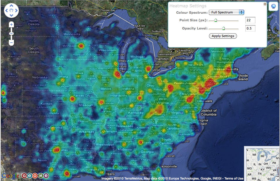
SF: Whilst traditional clients are keen to explore a more agile approach to Web mapping and take some tentative steps into the cloud, the clients that I worked with in the past were concerned about good design and functionality, high levels of service and availability, and most importantly a partner that they could trust. Geo.me offers a rich functionality set including powerful heat mapping, charting, dynamic clustering of points and simple integration of feeds that are controlled and configured by the client, not a developer. From the early responses, I think we are in the right place at the right time.
 |
DM: Who are the intended customers for Geo.me? The same folks who would use one of the APIs? How will you convince them they need more than what's available in that API?
SF: Our customers will largely be from one of three areas. Those already using the existing mapping APIs but looking for extended functionality, features or data to interact with; those using complex GIS systems who need a user-friendly Web interface and potentially specialized or complex Web features; and finally those businesses that don't have in-house expertise and need a low cost and rapidly configured mapping solution. Specific sectors that will find us attractive include local government, travel and tourism, and businesses with a large footprint or customer base such as the retail market.