Managing water, sewer and stormwater infrastructure is
a difficult task for any municipality or government agency.Constrained
budgets, environmental regulations, aging infrastructure and rapidly
changing technology are just some of the challenges faced by public
utility managers.GIS has become an important tool for municipal
utility managers to record utility asset information and relate that
information to the world around them (customers, roads, government
boundaries and waterways).The implementation of an enterprise GIS can
provide a municipal utility with an enormous return on investment (ROI)
if properly designed and maintained.
Most utilities rely on accurate base mapping information (digital aerial photography, tax parcels, street centerlines, etc.) to record the location of their assets.Generally, throughout the U.S., base mapping information is coordinated at the state level and regionally by counties.This is true in the State of New Jersey, where the New Jersey Geographic Information Network (NJGIN) and the New Jersey Department of Environmental Protection (NJDEP) provide the framework for statewide coordination of spatial data.However, GIS coordination at the regional level (e.g.between counties and municipalities) can be challenging, especially in a state like New Jersey.
New Jersey is a "home rule state." As defined by the New Jersey League of Municipalities, home rule is "the power granted either by the Constitution or Legislature or both to municipal governments to organize themselves to carry out a range of governmental activities under their own authority, and to preserve health, safety and general welfare." In layman's terms, this means that New Jersey's 500+ municipalities can perform many of their functions independent of the state and their respective counties, including GIS implementation. Factor in hundreds of municipal utility authorities and private utilities in the state and you have the makings of an extremely complicated process for managing water, sewer and stormwater assets.
Nobel Systems Inc., a GIS/IT consulting company firm from San Bernardino, California, that recently opened an office in Williamstown, NJ, and has focused its efforts of New Jersey's utility community.Nobel is taking an approach that it has perfected with utilities on the GIS-savvy West Coast and is adopting these techniques in markets such as New Jersey.
Hamilton Township Municipal Utilities Authority (HTMUA), Nobel's first New Jersey client, is located in Atlantic County.HTMUA provides water and sewer service to Hamilton Township, New Jersey's largest municipality by land area, just outside of Atlantic City.Although HTMUA has a GIS program that has been in place for over three years, they were looking to increase the functionality of their GIS, which was primarily limited to mapping, and increase their ROI.Nobel implemented an approach for HTMUA which will hopefully become the model for how utilities will manage spatial data in New Jersey and across the USA. The approach includes the following steps: education, development of standard data models, and development of data and applications.Each of these will be described further below.
Education
Improved utility information management and coordination starts with education.Too many utilities and municipalities get so caught in the day-to-day operations that they are not even aware of the free information all around them.
Besides water and sewer GIS layers, HTMUA was maintaining a number of base mapping layers such as tax parcels and aerial photography on their local servers.Most of these base mapping layers were already being maintained by Atlantic County's Office of GIS, one of the more advanced GIS programs in the state.Nobel was able to work with HTMUA to obtain and use the freely available base mapping information from the county and state, and develop a GIS program that focused on improving the accuracy and functionality of the utility's water and sewer data. Eliminating the need to maintain base mapping layers provided the HTMUA with immediate savings.
More than half of the counties in New Jersey make their GIS data available to the public via map servers, and almost every county in the state provides their base mapping data to public agencies for little or no cost.Regardless, there are numerous municipalities and utilities that are maintaining redundant sets of aerial photography and tax parcel data.Since most government agencies are not known for marketing capabilities, many well developed GIS datasets may never make it down to the municipalities or utilities who need them and vice versa.Due to the "home rule" form of government in New Jersey it is not uncommon to find some cities and larger municipalities with more advanced GIS programs than the counties into which they fall.Private consulting firms can play a key role in improving the coordination among government agencies and reducing redundant data creation and maintenance.
Standard Data Models
Unfortunately, much of the focus surrounding GIS for utilities centers on map production, rather than information management.New Jersey, like most states, has adopted various spatial data standards that are used throughout the state by counties, municipalities and private consultants.However these statewide standards focus on base mapping layers (base standard, transportation, hydrography, government units, geodetic control, elevation, digital orthoimagery and cadastre) and do not include public works and utility assets.For this reason many utilities rely on consulting engineers to manage their utility asset information.Municipal engineers are invaluable at providing CAD and surveying services but many lack the information technology and database management skills necessary to build an enterprise GIS.
Many utilities already have a number of existing information and/or legacy systems in place to manage customer billing, work orders, customer information, hydraulic modeling and capital planning.One of the primary reasons in developing a sound data model is to develop GIS data that is scalable enough to integrate and add value to these systems.Too many utilities focus primarily on mapping infrastructure and do not realize the significant ROI that can be achieved when GIS becomes part of their asset and management systems.
Since there were no state or county utility data standards, we worked with utilities like HTMUA to utilize the freely available water and sewer data model that ESRI created with the help of hundreds of utilities across the USA.Nobel took the ESRI Water Utilities Data Model and customized it for HTMUA to suit their specific needs.The data model is being used as the foundation for creating an enterprise water and sewer geodatabase that will serve as the heart of many of HTMUA's information management operations.The data model has even been expanded to include infrastructure maintained by private developers within the municipality and regional utility authorities such as the Atlantic County Utilities Authority (ACUA).
Nobel has already started working with ACUA to develop a regional sewer data model that could be used by all sewer utility operators, private and public, within Atlantic County.A regional data model will be used to improve hydraulic modeling, work order management and utility operations across municipal boundaries.This regional approach is already being expanded to other parts of the state as we have recently started working with Northwest Bergen County Utilities Authority, a regional sewer authority which serves a dozen municipalities in Bergen County, NJ.
Rapidly Deploy Data and Applications
The key to gaining management support for any GIS program is the effective use of user-friendly applications.With many Internet Map Servers already in place within New Jersey, Nobel has developed an approach which leverages the investments that have already been made in data, hardware and software.
Utilizing ESRI's scalable ArcGIS software, we were able to rapidly deploy applications that utilities are accustomed to, such as ArcView and ArcExplorer.However, rather than copying redundant state and county datasets to local file servers, we worked with utilities like HTMUA to utilize their ESRI software to dynamically access data stored on these state and county map servers.Utility staff now has access to the most relevant state and county base mapping information and has the ability to overlay water and sewer data to relate utility layers to other GIS datasets such as parcels.
Application Service Provider
For many municipal utilities, setting up and managing an Internet map server is not possible due to budget constraints and a lack of the necessary IT skill sets.Furthermore, turning over sensitive utility information to state and county GIS offices to be hosted on public map servers is not an option at a time when security and emergency management is so important.
Again we leveraged ESRI technology to develop an application service called GeoViewerIMS.It allows clients to host data and maps on secure, private Internet map servers.Private hosting services like GeoViewerIMS have provided utilities with the flexibility of deploying information to anyone within the organization, at any location, without the overhead involved with hardware, software and GIS/IT staff. GeoViewerIMS also has custom developed tools for utilities.such as sewer network traces, valve isolation and mailing label wizards, which provide users with functionality beyond the standard ArcIMS interface. The service can also be connected to other Internet map servers to provide the end user with a seamless gateway to volumes of data.
HTMUA has some experienced GIS users (<1% of staff) with needs that require the advanced GIS capabilities of ESRI's ArcView.We set these users up with an ArcView project file that dynamically connects to the various map servers (GeoViewerIMS, Atlantic County, NJGIN) to access the appropriate datasets.Users can also store data locally on the network or hard drive.There are other "moderate" GIS users (2-5% of staff) who connect to these same map servers via ESRI's free ArcExplorer data browser, and a custom project file, that gives them functionality beyond the standard web browser.Lastly, the remainder of the staff (90+%) and other authorized users gain access to the utility's data via a standard web browser using the GeoViewerIMS service.
With a private hosting service, HTMUA has enterprise GIS functionality without much of the overhead attributed to GIS hardware and software.HTMUA can also control access to its water and sewer data by providing user accounts to engineers, surveyors and other utilities.
This type of an approach to information management is not uncommon among managers of tax parcel and assessment information.The inherent difficulty of managing water and sewer utility network data in an enterprise GIS environment is a big reason why utilities have been left out of the GIS coordination game.However, the development of industry standard utility data models and the customization of these models for various regions throughout the country will improve the quality and coordination of water and sewer information.
Most utilities rely on accurate base mapping information (digital aerial photography, tax parcels, street centerlines, etc.) to record the location of their assets.Generally, throughout the U.S., base mapping information is coordinated at the state level and regionally by counties.This is true in the State of New Jersey, where the New Jersey Geographic Information Network (NJGIN) and the New Jersey Department of Environmental Protection (NJDEP) provide the framework for statewide coordination of spatial data.However, GIS coordination at the regional level (e.g.between counties and municipalities) can be challenging, especially in a state like New Jersey.
 |
| The organization of state and regional Internet map servers (IMS) in the State of New Jersey's GIS.Source: Nobel Systems. Click image for larger view. |
New Jersey is a "home rule state." As defined by the New Jersey League of Municipalities, home rule is "the power granted either by the Constitution or Legislature or both to municipal governments to organize themselves to carry out a range of governmental activities under their own authority, and to preserve health, safety and general welfare." In layman's terms, this means that New Jersey's 500+ municipalities can perform many of their functions independent of the state and their respective counties, including GIS implementation. Factor in hundreds of municipal utility authorities and private utilities in the state and you have the makings of an extremely complicated process for managing water, sewer and stormwater assets.
Nobel Systems Inc., a GIS/IT consulting company firm from San Bernardino, California, that recently opened an office in Williamstown, NJ, and has focused its efforts of New Jersey's utility community.Nobel is taking an approach that it has perfected with utilities on the GIS-savvy West Coast and is adopting these techniques in markets such as New Jersey.
Hamilton Township Municipal Utilities Authority (HTMUA), Nobel's first New Jersey client, is located in Atlantic County.HTMUA provides water and sewer service to Hamilton Township, New Jersey's largest municipality by land area, just outside of Atlantic City.Although HTMUA has a GIS program that has been in place for over three years, they were looking to increase the functionality of their GIS, which was primarily limited to mapping, and increase their ROI.Nobel implemented an approach for HTMUA which will hopefully become the model for how utilities will manage spatial data in New Jersey and across the USA. The approach includes the following steps: education, development of standard data models, and development of data and applications.Each of these will be described further below.
Education
Improved utility information management and coordination starts with education.Too many utilities and municipalities get so caught in the day-to-day operations that they are not even aware of the free information all around them.
Besides water and sewer GIS layers, HTMUA was maintaining a number of base mapping layers such as tax parcels and aerial photography on their local servers.Most of these base mapping layers were already being maintained by Atlantic County's Office of GIS, one of the more advanced GIS programs in the state.Nobel was able to work with HTMUA to obtain and use the freely available base mapping information from the county and state, and develop a GIS program that focused on improving the accuracy and functionality of the utility's water and sewer data. Eliminating the need to maintain base mapping layers provided the HTMUA with immediate savings.
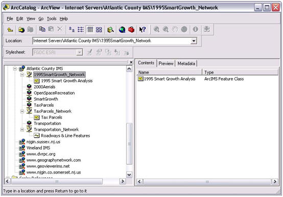 |
| Many counties, like Atlantic County, NJ, provide access to various GIS datasets via Internet Map Servers.Water and sewer utilities can achieve immediate savings on their GIS programs by utilizing freely available GIS data for their base maps.Source: Nobel Systems.Click image for larger view. |
More than half of the counties in New Jersey make their GIS data available to the public via map servers, and almost every county in the state provides their base mapping data to public agencies for little or no cost.Regardless, there are numerous municipalities and utilities that are maintaining redundant sets of aerial photography and tax parcel data.Since most government agencies are not known for marketing capabilities, many well developed GIS datasets may never make it down to the municipalities or utilities who need them and vice versa.Due to the "home rule" form of government in New Jersey it is not uncommon to find some cities and larger municipalities with more advanced GIS programs than the counties into which they fall.Private consulting firms can play a key role in improving the coordination among government agencies and reducing redundant data creation and maintenance.
Standard Data Models
Unfortunately, much of the focus surrounding GIS for utilities centers on map production, rather than information management.New Jersey, like most states, has adopted various spatial data standards that are used throughout the state by counties, municipalities and private consultants.However these statewide standards focus on base mapping layers (base standard, transportation, hydrography, government units, geodetic control, elevation, digital orthoimagery and cadastre) and do not include public works and utility assets.For this reason many utilities rely on consulting engineers to manage their utility asset information.Municipal engineers are invaluable at providing CAD and surveying services but many lack the information technology and database management skills necessary to build an enterprise GIS.
Many utilities already have a number of existing information and/or legacy systems in place to manage customer billing, work orders, customer information, hydraulic modeling and capital planning.One of the primary reasons in developing a sound data model is to develop GIS data that is scalable enough to integrate and add value to these systems.Too many utilities focus primarily on mapping infrastructure and do not realize the significant ROI that can be achieved when GIS becomes part of their asset and management systems.
Since there were no state or county utility data standards, we worked with utilities like HTMUA to utilize the freely available water and sewer data model that ESRI created with the help of hundreds of utilities across the USA.Nobel took the ESRI Water Utilities Data Model and customized it for HTMUA to suit their specific needs.The data model is being used as the foundation for creating an enterprise water and sewer geodatabase that will serve as the heart of many of HTMUA's information management operations.The data model has even been expanded to include infrastructure maintained by private developers within the municipality and regional utility authorities such as the Atlantic County Utilities Authority (ACUA).
Nobel has already started working with ACUA to develop a regional sewer data model that could be used by all sewer utility operators, private and public, within Atlantic County.A regional data model will be used to improve hydraulic modeling, work order management and utility operations across municipal boundaries.This regional approach is already being expanded to other parts of the state as we have recently started working with Northwest Bergen County Utilities Authority, a regional sewer authority which serves a dozen municipalities in Bergen County, NJ.
Rapidly Deploy Data and Applications
The key to gaining management support for any GIS program is the effective use of user-friendly applications.With many Internet Map Servers already in place within New Jersey, Nobel has developed an approach which leverages the investments that have already been made in data, hardware and software.
Utilizing ESRI's scalable ArcGIS software, we were able to rapidly deploy applications that utilities are accustomed to, such as ArcView and ArcExplorer.However, rather than copying redundant state and county datasets to local file servers, we worked with utilities like HTMUA to utilize their ESRI software to dynamically access data stored on these state and county map servers.Utility staff now has access to the most relevant state and county base mapping information and has the ability to overlay water and sewer data to relate utility layers to other GIS datasets such as parcels.
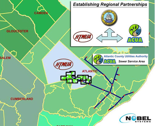 |
| Developing regional partnerships and data models amongst utility operators will improve coordination, increase operational efficiency, and will eliminate redundant data management efforts.Source: Nobel Systems.Click image for larger view. |
Application Service Provider
For many municipal utilities, setting up and managing an Internet map server is not possible due to budget constraints and a lack of the necessary IT skill sets.Furthermore, turning over sensitive utility information to state and county GIS offices to be hosted on public map servers is not an option at a time when security and emergency management is so important.
Again we leveraged ESRI technology to develop an application service called GeoViewerIMS.It allows clients to host data and maps on secure, private Internet map servers.Private hosting services like GeoViewerIMS have provided utilities with the flexibility of deploying information to anyone within the organization, at any location, without the overhead involved with hardware, software and GIS/IT staff. GeoViewerIMS also has custom developed tools for utilities.such as sewer network traces, valve isolation and mailing label wizards, which provide users with functionality beyond the standard ArcIMS interface. The service can also be connected to other Internet map servers to provide the end user with a seamless gateway to volumes of data.
HTMUA has some experienced GIS users (<1% of staff) with needs that require the advanced GIS capabilities of ESRI's ArcView.We set these users up with an ArcView project file that dynamically connects to the various map servers (GeoViewerIMS, Atlantic County, NJGIN) to access the appropriate datasets.Users can also store data locally on the network or hard drive.There are other "moderate" GIS users (2-5% of staff) who connect to these same map servers via ESRI's free ArcExplorer data browser, and a custom project file, that gives them functionality beyond the standard web browser.Lastly, the remainder of the staff (90+%) and other authorized users gain access to the utility's data via a standard web browser using the GeoViewerIMS service.
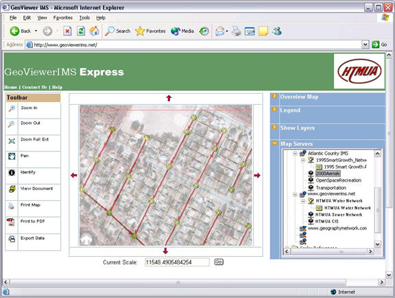 |
| Private map/data hosting services, like GeoViewerIMS, provide utilities with an affordable means to deploy utility information via the Internet.The integration of a private server with various state and county servers provides the utility with access to valuable base mapping information without the need to maintain local copies of the data.Source: Nobel Systems.Click image for larger view. |
With a private hosting service, HTMUA has enterprise GIS functionality without much of the overhead attributed to GIS hardware and software.HTMUA can also control access to its water and sewer data by providing user accounts to engineers, surveyors and other utilities.
This type of an approach to information management is not uncommon among managers of tax parcel and assessment information.The inherent difficulty of managing water and sewer utility network data in an enterprise GIS environment is a big reason why utilities have been left out of the GIS coordination game.However, the development of industry standard utility data models and the customization of these models for various regions throughout the country will improve the quality and coordination of water and sewer information.
From Our Homepage
Saying Farewell to an Amazing Journey
Communicating with Maps
Is There a GIS Career Ladder?
What does it mean to be geospatially smart? Series
Ways Real Estate and Property Developers Utilize Melissa GeoData for Data-Driven Decisions
Unlocking Value From Daily Satellite Imagery and Insights
Maximizing the Value of Your Address Data with Geo Addressing
How Indoor Mapping Enhances the Security of Smart Buildings
Look Ahead: AI, Location Intelligence and Efficiency
Collaboration Takes on Sea Level Rise & Dynamic Technology Environments
Brownies for Brownfields
Has Everything Been Mapped Already?
How Is Data Literacy Changing in an Artificial Intelligence Landscape
Portfolios for GIS Professionals: More Than Just Maps
How to Create a Distance Matrix in QGIS - A Step-by-Step Guide
7 Ideas for Bringing GIS into the K-12 Classroom
The Geography of Movement