The Location Intelligence Conference offered two sessions of quick demos of mashups. Watching the parade, which included everything from the original housingmaps.com introduced by its creator and now Google employee Paul Rademacher to some business applications for real estate staffers from Sperry Van Ness introduced by Tom Sanchez, I realized we are ready for Mashups 2.0.
I don't mean to suggest that traditional mashups of databases/websites/etc. and maps are no longer valuable, but they are frankly a dime a dozen. (Those exposing the APIs deserve credit for the commoditization of this practice.) It's time to go beyond - and Sperry Van Ness has. Its mashup allows employees to easily create real estate documents that include maps. Another allows end users to create their own webpages to advertise properties for sale.
 |
I think we've cleared a hurdle in Web 2.0 progress as these and other more solution-focused mashups appear and those that simply put dots on the map slip out of the spotlight.
2. Accessing and Using Hidden Location-based Information
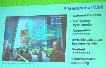
Mike Liebhold presented the first keynote. Leibhold showed a graphic I'd seen before from Scientific American from some years back. It encapsulated his vision of the physical world teaming with hidden information. In the future, he contended, we'll be able to access and use this location-based information via a variety of devices. The most interesting method he mentioned was the "RFID flashlight." When shined on an RFID chip on a container, it projects its stored information onto the container or a nearby wall for examination. It's the perfect metaphor for exposing hidden information.
 |
3. Free Data are Not Free
A panel titled "How long will free geospatial data be free?" prompted some interesting input, the most profound of which came from Ed Parsons, CTO of the Ordnance Survey, Great Britain. Parsons argued, quite convincingly, that free data are not free, they are simply not paid for by "you." So, Google pays for Google Earth's free data. The taxpayers pay for the U.S. government's free data. Licensees and those who buy maps pay for the Ordnance Survey's data. Even the free data from projects like OpenStreetMap are not free; they are paid for via the sweat equity of those who collect and make them available. Parsons went on to offer the analogy that "free data" from, say Google and Yahoo, is akin to drug dealers offering "free samples" only to get potential users hooked and willing to pay down the road.
4. Licensing and Support Issues are Distinguishers
MapQuest, PlaceBase and others worked hard to highlight their licensing and support, to contrast their free and non-free offerings from free APIs from other players. Service level agreements, long-term support, promises of no ads, etc. are topics raised to help the choosy developer make "the right choice" of a mapping platform. There are a few things pushing that change. (1) Mapping platforms are a dime a dozen and data differences are diminishing. (2) User needs are demanding fewer "fun, informal websites" and more "mission critical applications."
 |
Three-dimensional visualization, especially of urban environments, popped up in several sessions. David Colleen of Planet 9 literally told the story of its introduction to 3D on the Web and showed some of its city plans. In the early days, the company would produce small cityscapes and it wanted to link these to websites of the business located there. But it was too early in the history of the Web and these companies had no such pages! So, Planet 9 built the pages for them! A presenter or two (including Microsoft) referred to its "street side" demo. How does one make money on 3D visualization? Is it different from making money from 2D maps? Those questions did not come up; perhaps it's too early for that question in the context of location intelligence.
6. The Role of Traditional GIS in the New Location Intelligence
Traditional GIS companies, while in attendance, were frankly not the topic of conversation. Why? Is it because their tools are in the basement of the supply chain, that is, used in the development of data? Is it because these high-end analytic tools are not yet being exploited in the new Web-based mashup world of LI? Is it because they don't speak this language?
7. Clearest Vision
Mike Jones of Google clearly and respectfully offered his company's (and perhaps the entire industry's) vision of the future in a three-part statement. First, the future is about being smart, but in the sense that an application like Google Local makes you feel smart and equipped to face the world. I liked that he connected what the app did with how it made you feel. (That's good marketing!) Second, he pointed to participatory cartography as part of the future. That is, it will be necessary (and fun) for everyone to add to the database of geographic geometry information as well as to the list of attributes that geometry holds. (Hence the acquisition of SketchUp.) Thirdly, he noted that the future is happening now, in part because everyone's expectations are changing regarding what they want and need from maps and the Web.
 |
I believe I heard the same question on more than one occasion during the conference: "How come you guys don't have the same API?" I found it a curious question. Vincent Tao, who recently joined Microsoft from acquired GeoTango, offered an interesting analogy about standards. He explained that you can standardize some things, say shoe sizes, but not others, say colors/styles. That, he suggests, keeps interoperability between shoes, but does not limit innovations in style. I spoke with a few "mashup developers" who assured me that, while the APIs were different, they were not that different. It was not a big deal to recode an app from one to another. The biggest challenge? They use different "zoom scales" so that can be hard to align from one to the next.
9. GeoRSS Explodes
The most used term at the event, across all the sessions I attended (which focused on tech rather than ROI): GeoRSS. It was in the keynote; it was in the discussion of standards; it was in the discussion of participatory cartography, Web 2.0, etc. So what is GeoRSS? It's an emerging standard that embeds simple to complex geographic information in RSS feeds. What does that mean? A GeoRSS encoded feed can be "fed into" a client that understands it and can map it. Among the major players, Yahoo was early out of the gate to support GeoRSS, but Microsoft has it slated for an upcoming version of Virtual Earth, if I understand correctly.
For those who need to know, there is an "old" GeoRSS, which came out of the World Wide Web Consortium (W3C). That's the one Yahoo has implemented. The "new" OGC-involved one "serves informally as an extension to the W3C geo (point) vocabulary (sometimes also referred to as "GeoRSS"), adding important additional kinds of location (points, lines, and boundaries) as well as other extensibility." Gory details are at the discussion list.
The enhanced GeoRSS is important for a few reasons. First, a group outside of W3C/OGC jumped on an obvious problem and offered a solution. Since they have been involved in OGC, they used the ideas it uses to work together. Now, that idea is on course to become an OGC standard. Second, the idea got grass roots support. Third, players like Yahoo saw the value of implementing the "not-yet a standard," and did so.
10. Tracking Insight
The tracking of goods/people/vehicles may account for much of the financial benefit of location intelligence. Alex Walker, CEO of CubeRoute, made it clear that tracking, in and of itself, has little value. The value comes in knowing where something is (or at what temperature it is, etc.) in comparison to where it's supposed to be (or what temperature it's supposed to be). That goes directly back to turning raw data into information (information being something that causes action). It's that turning data into information that creates value.
From Our Homepage
Saying Farewell to an Amazing Journey
Communicating with Maps
Is There a GIS Career Ladder?
What does it mean to be geospatially smart? Series
Ways Real Estate and Property Developers Utilize Melissa GeoData for Data-Driven Decisions
Unlocking Value From Daily Satellite Imagery and Insights
Maximizing the Value of Your Address Data with Geo Addressing
How Indoor Mapping Enhances the Security of Smart Buildings
Look Ahead: AI, Location Intelligence and Efficiency
Collaboration Takes on Sea Level Rise & Dynamic Technology Environments
Brownies for Brownfields
Has Everything Been Mapped Already?
How Is Data Literacy Changing in an Artificial Intelligence Landscape
Portfolios for GIS Professionals: More Than Just Maps
How to Create a Distance Matrix in QGIS - A Step-by-Step Guide
7 Ideas for Bringing GIS into the K-12 Classroom
The Geography of Movement