MapInfo and one of its Canadian
partners, Korem, hosted the GEOdiffusion conference last
week in Quebec City.Mike Hickey, COO of MapInfo provided this
perspective on location intelligence in his opening comments: "Location
Intelligence is disruptive because it is no longer a separate IT
function," he said.Hickey succinctly stated a market trend that many
geospatial companies are noticing.MapInfo has been in a
transitional state for several years moving toward industry specific
market solutions.As a company, it has tried to move product
development, such as with MapInfo Professional, in parallel with
solutions for enterprise computing by leveraging domain expertise in
the retailing, banking and insurance industries.It is precisely this
kind of transition that will allow the company to hold a more
competitive posture as specific industries look to incorporate location
technology with other business processes.Hickey noted that MapInfo's
4.3 million share offering last April raised $44.2 million with the
expressed purpose of growing the business through acquisition.
The GEOdiffusion Conference is a small gathering of approximately 125 people, mainly customers of Korem from the Quebec region.It provides an opportunity to both understand what customers are doing and to get a mid-year update on MapInfo's product direction.Korem's Push n' See software is a rapid prototyping solution for delivering MapInfo project data to the Web.It is Java-based and can quickly offer someone who is not familiar with programming Web mapping software an opportunity to push map data to the web.Push n' See should not be confused with MapInfo's Exponare, also a rapid development platform based on .NET.
MapInfo Positioning
The following diagram offers a high level view of MapInfo product positioning:
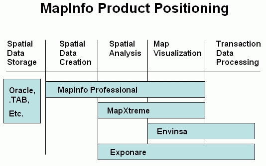
MapInfo Professional v.8 (MiPro) was released last June and still serves as the company's flagship desktop mapping product.Directions Magazine did a comprehensive review of the product at the time.MiPro v.8.5 will be released in June 2006 and MapInfo will continue to support its current technology (read support/enhance MiPro and MapBasic) meaning that the company will follow a dual product strategy.See below for more of an explanation.
"Project Grande"
Project Grande is MapInfo's next generation technology.The first release is targeted to beginners and intermediate skill users and will have a redesigned graphic user interface.The company is not "chasing" any specific date for release but has begun to provide a select user group with software for testing.The new product will have customization and extensibility options that will be programmable with a .NET environment.Essentially, the new product will be a "MiPro lite" version with not all of the functionality of the current MiPro product. The company will develop this new technology while maintaining its current platform for MiPro.
Development Platforms
MapInfo positions its development platforms to conform to skill sets of its customers who want to deploy certain location-based information to a broader audience.MapXtreme 2004 is a development platform that can be customized with VB.NET for internet mapping.MapXtreme Java is the Java version that supports J2EE tools; and Envinsa is an application programming interface that is appropriate for delivering Web services and supports XML, .NET or Java.
Link to Google Earth
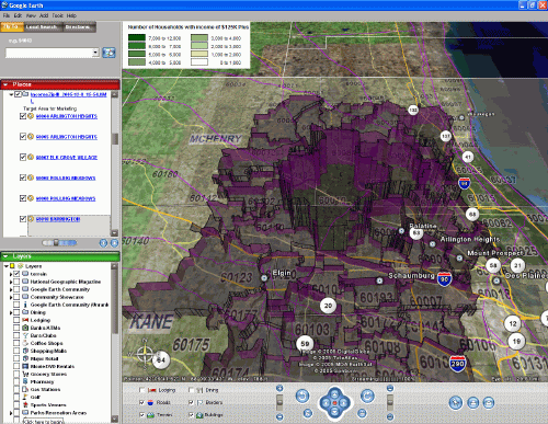
MapInfo now offers a link to Google Earth for MiPro v.8.The Google Earth Link utility (documentation) allows a MapInfo Professional user to export the current map window as an object (See graphic below; Directions Magazine will publish a more in depth article on this soon). When the user clicks on the object it will open Google Earth and drape the map window results onto the base map layer of Google Earth.The user can export thematic maps or three dimensional prism maps and have them displayed on Google Earth along with the map legend. The Google Earth Link implementation uses KML to export the object.The plugin is only available if you have MiPro v.8 installed.The user would need to go the HELP menu and "check for updates" in order to download it.
One customer from the Banque National du Canada mentioned that Google
presents a challenge to software providers and she considered Google
the new standard as a user interface.
Summary
The conference provided an opportunity to better understand MapInfo's current product development approach."Project Grande" has been anticipated for at least two years and looks to be finally coming to fruition, even in a beta mode.In addition, MapInfo continues to push its domain expertise in niche solutions (retail, insurance, and banking) and to work with its partners to offer software solutions that leverage either or both .NET and Java platforms.
The GEOdiffusion Conference is a small gathering of approximately 125 people, mainly customers of Korem from the Quebec region.It provides an opportunity to both understand what customers are doing and to get a mid-year update on MapInfo's product direction.Korem's Push n' See software is a rapid prototyping solution for delivering MapInfo project data to the Web.It is Java-based and can quickly offer someone who is not familiar with programming Web mapping software an opportunity to push map data to the web.Push n' See should not be confused with MapInfo's Exponare, also a rapid development platform based on .NET.
MapInfo Positioning
The following diagram offers a high level view of MapInfo product positioning:
MapInfo Professional v.8 (MiPro) was released last June and still serves as the company's flagship desktop mapping product.Directions Magazine did a comprehensive review of the product at the time.MiPro v.8.5 will be released in June 2006 and MapInfo will continue to support its current technology (read support/enhance MiPro and MapBasic) meaning that the company will follow a dual product strategy.See below for more of an explanation.
"Project Grande"
Project Grande is MapInfo's next generation technology.The first release is targeted to beginners and intermediate skill users and will have a redesigned graphic user interface.The company is not "chasing" any specific date for release but has begun to provide a select user group with software for testing.The new product will have customization and extensibility options that will be programmable with a .NET environment.Essentially, the new product will be a "MiPro lite" version with not all of the functionality of the current MiPro product. The company will develop this new technology while maintaining its current platform for MiPro.
Development Platforms
MapInfo positions its development platforms to conform to skill sets of its customers who want to deploy certain location-based information to a broader audience.MapXtreme 2004 is a development platform that can be customized with VB.NET for internet mapping.MapXtreme Java is the Java version that supports J2EE tools; and Envinsa is an application programming interface that is appropriate for delivering Web services and supports XML, .NET or Java.
Link to Google Earth
MapInfo now offers a link to Google Earth for MiPro v.8.The Google Earth Link utility (documentation) allows a MapInfo Professional user to export the current map window as an object (See graphic below; Directions Magazine will publish a more in depth article on this soon). When the user clicks on the object it will open Google Earth and drape the map window results onto the base map layer of Google Earth.The user can export thematic maps or three dimensional prism maps and have them displayed on Google Earth along with the map legend. The Google Earth Link implementation uses KML to export the object.The plugin is only available if you have MiPro v.8 installed.The user would need to go the HELP menu and "check for updates" in order to download it.
Summary
The conference provided an opportunity to better understand MapInfo's current product development approach."Project Grande" has been anticipated for at least two years and looks to be finally coming to fruition, even in a beta mode.In addition, MapInfo continues to push its domain expertise in niche solutions (retail, insurance, and banking) and to work with its partners to offer software solutions that leverage either or both .NET and Java platforms.
From Our Homepage
Saying Farewell to an Amazing Journey
Communicating with Maps
Is There a GIS Career Ladder?
What does it mean to be geospatially smart? Series
Ways Real Estate and Property Developers Utilize Melissa GeoData for Data-Driven Decisions
Unlocking Value From Daily Satellite Imagery and Insights
Maximizing the Value of Your Address Data with Geo Addressing
How Indoor Mapping Enhances the Security of Smart Buildings
Look Ahead: AI, Location Intelligence and Efficiency
Collaboration Takes on Sea Level Rise & Dynamic Technology Environments
Brownies for Brownfields
Has Everything Been Mapped Already?
How Is Data Literacy Changing in an Artificial Intelligence Landscape
Portfolios for GIS Professionals: More Than Just Maps
How to Create a Distance Matrix in QGIS - A Step-by-Step Guide
7 Ideas for Bringing GIS into the K-12 Classroom
The Geography of Movement