 Founded in
1972, the Macerich Company has become one of the largest owners and
operators of regional shopping malls in the United States.The
company's proactive growth and management strategies are at the heart
of its success.But until recently, its property management practices
were slowed by dependence on paper based, color coded property plans.
Since turning to Autodesk MapGuide and Oracle solutions to generate
color coded plans online, Macerich now has the information it needs to
make better, faster decisions, saving thousands of hours each year in
the decision making process.
Founded in
1972, the Macerich Company has become one of the largest owners and
operators of regional shopping malls in the United States.The
company's proactive growth and management strategies are at the heart
of its success.But until recently, its property management practices
were slowed by dependence on paper based, color coded property plans.
Since turning to Autodesk MapGuide and Oracle solutions to generate
color coded plans online, Macerich now has the information it needs to
make better, faster decisions, saving thousands of hours each year in
the decision making process.Macerich's business strategy is simple: purchase leading regional malls and turn them into dominant regional malls through smart redevelopment, leasing and marketing practices.With its occupancy rates and tenant sales consistently among the highest in the industry, the strategy is an undisputed success."At Macerich, we strive to be a great company in general, not just within our industry," explains J.P.Jones, Macerich's chief information officer."We're always looking for innovative ways improve our processes and technology.Where many in the industry are still using highlighters and spreadsheets to color code property plans, we're doing it instantly with Autodesk MapGuide.It's helping us to carry out our business strategy even more effectively."
As is often the case, innovation came hand in hand with unfamiliar technology.Embracing MapGuide meant that Macerich's IT staff needed to learn how to integrate graphical data with tabular data.So Macerich turned to Autodesk Consulting to lead the implementation.
The practice of color coding property plans has long been an important - if somewhat low-tech - part of retail property management. Traditionally, a leasing or property manager uses a highlighter to mark up a paper plan of a property based on the criteria that need to be analyzed or illustrated.Different colors are used to represent where a particular store stands in relation other stores in the property.For instance, a color coded lease plan - visually depicting different lease expiration dates in different colors - is used to analyze and account for upcoming vacancies in a property.In the leasing process, a lease plan that is colored based on sales volume by location and store type can be used to sell a potential tenant on leasing a location.
Before implementing MapGuide, the lease plan color coding process at Macerich was incredibly tedious.Employees who needed a colored plan created each one individually, using a black and white paper plan, highlighters and tabular data.Not merely slow, the plans were out of date as soon as the ink dried.Because it was so time consuming to color plans for presentations, leasing staffers were hampered in their ability to create as many high quality, custom plans as they would have liked.And on the enterprise level, color coded lease plans for every Macerich property were only updated on a quarterly basis."We're in a dynamic business, but the colored paper plans we used were completely static, limiting our ability to manage proactively," says Jones."Our Oracle database contained the real-time data we needed for over 8,000 individual leases, but in a tabular form.We needed a faster way to turn reports and leasing data into color coded plans."
Choosing the right solution
In 2002, Macerich acquired Westcor, another owner and operator of regional malls.With J.P.Jones as its CIO, Westcor had adopted a digital solution several years prior.When Jones became the CIO of Macerich, he decided it was time for Macerich to throw away its highlighters.Although the solution Westcor used was better and faster than coloring plans by hand, the solution wasn't compatible with Macerich's Oracle Property Manager database.Jones says, "We collect over 420 data points per lease in our Oracle database, and we wanted a solution that could use that wealth of data to build color coded and interactive floor plans."
Ready to adopt a digital solution, the Macerich team evaluated three plan color coding products, including MapGuide.The decision making team was impressed with the wide array of processes, such as facilities management, infrastructure maintenance, and land use planning, for which companies and governments were utilizing MapGuide.But it was MapGuide's ability to integrate with Oracle technology that sold Macerich on it."Autodesk MapGuide is a very dynamic tool," notes Jones."And because MapGuide is designed to integrate seamlessly with Oracle database technology, we thought it was the perfect vehicle for making our data more dynamic."
Its technology choice made, Macerich assembled an implementation team to carry out its vision.Autodesk Consulting, chosen for its strong methodology and expertise with both graphical and tabular data, led the Autodesk MapGuide implementation from the beginning.At every phase of the project, from defining the requirements to designing the user interface and building the application framework to knowledge transfer, the consulting team took a collaborative approach and worked closely with Macerich's IT department and end users.Two other key players also collaborated with Macerich and Autodesk Consulting on the project. Already on hand to work with Macerich's Oracle Property Manager database, Oracle Consulting created the data structures.And CADsoft Consulting, a provider of technology services to design professionals, prepared the CAD standard and graphical data.
One of the key challenges on the project was ensuring that the solution could develop meaningful data for each of Macerich's properties without property-by-property customization.In terms of revenue and performance, each property in Macerich's portfolio is distinct and has unique targets.For instance, rents and sales per square foot can vary widely by region.To account for these differences, the solution was customized to analyze information dynamically and to generate performance based color legends automatically."By averaging the lease and sales information coming from our Oracle database, MapGuide creates meaningful lease plan legends on-the-fly," says Jones."So in a color coded lease plan, red means 'take action' and blue means 'okay' across all our properties." The first release was developed in just nine weeks.
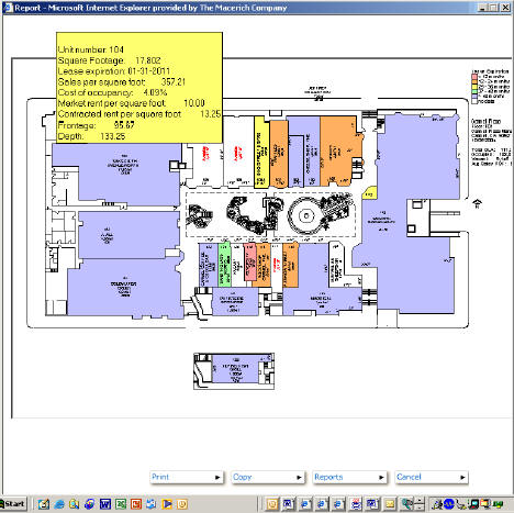 |
The "Macerich Interactive Lease Plan," as it came to be called, was rolled out to Macerich employees.It can run six different types of reports, each containing multiple data parameters.For instance, a property manager can create a color coded lease plan that references information such as expiration dates, rent or sales data."We're already developing additional reports based on user feedback," reports Jones."In leasing meetings, the color coded plans are a quick way to illustrate why a specific location might be ideal for a business."
Sold on the value of visual information for its leasing and property management employees, Macerich plans to roll out Autodesk DWF Composer, a tool for sharing and annotating design files.Macerich's leasing and property management staff will use the tool to notate designs to speed presentation creation."
The result: 2,500 hours saved annually and improved analysis
The solution is saving the company's employees thousands of hours annually.According to Jones, "Our Autodesk MapGuide solution is helping us to make profitable decisions and find new opportunities, such as advantageous tenant moves, more quickly by giving us better visibility into the data in our Oracle database.Compared to coloring lease plans by hand each quarter, our Autodesk MapGuide solution is saving us 2,500 hours annually."
He adds, "Autodesk MapGuide is also helping us to create more plans more often.We're now updating all our lease plans on a weekly instead of a quarterly basis.The solution helps us to explore and understand things like why sales might be low in one area of a property.These kinds of analyses were very time consuming before our MapGuide implementation."
From Our Homepage
Saying Farewell to an Amazing Journey
Communicating with Maps
Is There a GIS Career Ladder?
What does it mean to be geospatially smart? Series
Ways Real Estate and Property Developers Utilize Melissa GeoData for Data-Driven Decisions
Unlocking Value From Daily Satellite Imagery and Insights
Maximizing the Value of Your Address Data with Geo Addressing
How Indoor Mapping Enhances the Security of Smart Buildings
Look Ahead: AI, Location Intelligence and Efficiency
Collaboration Takes on Sea Level Rise & Dynamic Technology Environments
Brownies for Brownfields
Has Everything Been Mapped Already?
How Is Data Literacy Changing in an Artificial Intelligence Landscape
Portfolios for GIS Professionals: More Than Just Maps
How to Create a Distance Matrix in QGIS - A Step-by-Step Guide
7 Ideas for Bringing GIS into the K-12 Classroom
The Geography of Movement