Vendor Information
Manifold Net Ltd.
1945 North Carson Street
Suite 700
Carson City, NV
89701
1-800-556-5919
http://www.manifold.net
Price $245
Installation
The installation for
Manifold System consists of a three step process. I would recommend users
print out the readme files for each step before the installation. Each
step is listed under a Setup directory on the Manifold CD. In the first
step, you go to the directory of your operating system and load updated
Microsoft drivers for your operating system such as Microsoft Data Access
Components and Jet. The second step of the installation loads Microsoft
Internet Explorer 6 and a security fix for Internet Explorer 6. Manifold
recommends that users go to Microsoft’s website and check for any further
updates. The last step loads the Manifold System onto your computer. There
is a Manifold Service Pack 3 that is available on their website where users
can also register and activate Manifold online.
Documentation
Manifold includes a
Microsoft Word document file on the installation CD. The documentation
is 2,447 pages long and includes many images. The size of the file and
the number of images takes a long time for MS Word to completely load the
file which makes the scrolling through the file very slow until the file
is completely loaded. Manifold suggests that users spend at least a day
reading the Introduction section and working through examples in the Examples
section in the documentation. Manifold’s documentation introduces GIS users
to many new methods, user interfaces, terminology and concepts that are
not available in traditional GIS software. The Manifold documentation includes
a very thorough listing of free national and international data sources
available on the Internet.
Getting Started
Manifold’s main documents
are projects that are stored with a .map extension. Projects contain a
portfolio of components such as images, drawings, tables, labels, charts,
maps, etc. Comments, queries and scripts are called text components because
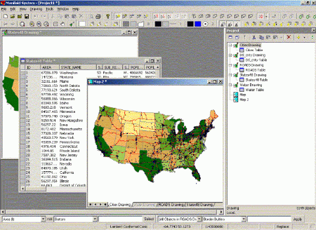
they contain text. Figure 1 is a screen shot that shows the Manifold System
GIS. There is a Map component pane, Drawing component pane, Table component
pane and the Project pane is shown on the right.

Figure 1 - Manifold
System GIS screen shot
[Click image for
larger view]
The Project pane shows
the components that are in the current project. When importing a component
into a project, the entire contents of that component are stored in a special
section of the project file. Manifold can import data from over 70 different
vector, raster, terrain elevation and database formats. One thing to note
about importing data, Manifold always goes back to a default location on
the hard drive when you choose to import, as opposed to going back to the
directory from the previous import. Once a component is imported into Manifold,
it is now in the project and has no tie to the original format or file
from which it originated. Therefore, a user can edit the contents of the
original data in Manifold without changing the source data. Manifold’s
reasoning for this is the price of hard drive space has come down in recent
years that we can afford to store larger map files since everyone has larger
hard drives now.
To view an individual
component, the user double-clicks on the component which opens a new pane.
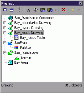
You can also view the attribute information for a drawing by clicking on
the plus (+) sign next to a drawing and will list the attribute table under
the drawing name. (See Bay_roads Drawing and Bay_roads table in Figure
2)

Figure 2 - Manifold
Project pane
Map panes are seen in a special type of window that has layer tabs at the bottom. Maps are the main user interface in Manifold because maps show components like drawings, images, surfaces and labels components in layers. Maps show their contents in a stack of multiple layers and can apply a variety of effects such as transparency that work only with layers. Drawings and images are normally viewed through the map that includes them. Label components are almost always used within maps. Maps can show their contents using any desired projection no matter what the native projections might be of their constituent layers. Maps work faster if the drawings and images they contain as layers use the same projection that is requested of the map.
Maps are created by choosing File-Create-Map menu. Manifold adds the map name and an icon to the Project pane. (See Bay Area in Figure 2) A "map" in the project contains very little data, since the contents of the map are taken from the drawing and image components it contains. Users can then drag and drop components from the Project pane into the Map. The components will appear as separate tabs along the bottom of the Map window. Users can also open a Layer pane if there are many layers associated with a given map. You can only add components to a Map window that have been imported into the Project pane. The active layer will have a white tab while the inactive layers will appear in gray. Layers can be turned on and off by double-clicking on the Layer’s tab, the Layer’s name will be grayed out on the tab when it is turned off. Any changes made to the component in any window will simultaneously appear in all other windows showing that component.
Selecting Features-Tools
and Options
Selections can be done
on an image or on drawing. When selecting on an image, Manifold will highlight
the pixels on the image that match the selection criteria. Selections can
be saved in the Selection pane for easy referencing later on.
Manifold has a complete
set of selection tools. Users simply press the buttons for the selection
they are trying to accomplish. There are three sets of buttons for making
selections:
- Select Points, Lines, Areas, Labels, and Pixels
- Select Add, Remove, Invert, Subtract, and Intersect
- Select Touch, Shape, Freeform, Box, Circle, Circle on Center, Ellipse, and Ellipse on Center
There is a separate
button which Selects None and sets the selection style.
Database Functionality
Manifold includes a
powerful database engine, so users can work with drawings that include
many thousands of objects with many database fields per object in the drawing's
table. Every drawing in Manifold has a database table linked to it.
Manifold can also link tables into a project from external sources.
There are two types of database tables that may be imported or linked into a Manifold project:
- Tables from files and file types that may be opened directly by Manifold's own database engines and so require no other database software. These include .mdb, .dbf, .udl, .xls, .db, and .html files as well as ascii or text database files organized as comma separated value (.csv) form.
- Tables from data sources that are provided by external database engines via OLE DB. Some such sources may require external database software. OLE DB also includes support for ODBC. Manifold will install a default set of OLE DB/ODBC drivers for popular databases.
Queries can be created
from multiple tables using statements in Structured Query Language (SQL)
to say what the table should contain. ViewBots are a one-line analytic
instruments that are extremely useful for analyzing tables. ViewBots are
used to perform simple statistics, queries, and other functions, including
measurement functions such as the total area of selected objects.
Additional Functionality
Manifold has a completed
suite of image editing tools. Users can change the brightness/contrast,
hue/saturation, and adjust the RGB settings of images. Users can also select
areas of the image to save as a selection set which can be used to subtract
out areas of the image. For presentation map creations you can use editing
in drawings, create drop shadows with Gaussian blur, and apply a color
gradient to an image. Manifold allows users to georeference images with
tools that use control points to re-scale, reposition and warp an image
to match a known good drawing or image. Users can manual registration to
re-scale or reposition an image that doesn’t need wrapping. Once images
are georeferenced, they can be transformed to any geographic projection.
Manifold can import terrain elevation data from almost any format known and incorporate surfaces into maps as shaded 2D images showing relief, slope, and aspect or visualized as realistic 3D terrain views. Surfaces can be colored by the height of each pixel and the transparency of the surface can be adjusted to allow other map features, such as roads or rivers, to be displayed in top of the surface. Users can select out areas of the surfaces to create new components of certain areas of elevation.
Manifold's GPS Console provides interactive control over a GPS (Global Positioning System) device connected to the computer via a serial port. The GPS Console allows setting moving map mode or automatically fetching position and other data from the GPS device.
Manifold includes an Internet map server that can publish maps to Internet for people to view. Manifold IMS can publish maps, drawings, images or surfaces from .map files to Internet in conjunction with Microsoft's Internet Information Server (IIS). The .map file will be published as an .asp file when you export the map file to a web page.
Manifold can be customized in several ways. For rapid scripting in Manifold, they recommend users program with Jscript or VBScript within the software. For more extensive applications development, they recommend Visual Basic or Visual C++ within Visual Studio.
Conclusion
Manifold comes with
a lot of functionality built in for a reasonable price of $245/license.
This review took more time than I expected because of the amount of functionality
in the product. I would have like to have had more time for a more thorough
review of the product. Manifold suggests users spend at least a day to
read the introduction and perform the exercises, I would recommend
being prepared to spend a lot more time than that to become fully familiar
with all the functionality. Manifold also suggests that "serious" users
read the entire documentation which could take a great deal of time. There
are a lot of processes and terminology differences in Manifold System GIS
that experienced GIS people won’t be familiar with.
For more information
about Manifold System GIS, I would suggest looking at the Manifold discussion
forum being hosted on directionsmag.com HERE.
Editor's Note:
Please also see Manifold's comments regarding this review on our "Letter to the Editor" page.