In a recent editorial
I noted that it seemed the world, not just the geospatial world, was
having a bit of an application programming interface (API) explosion. I
cited the new API for the New York Times and one from HopSpot.
I could have listed many others as well. Last month Maponics, a company that offers
specialized, localized datasets (neighborhoods and postal carrier
routes [the boundary of a group of addresses to which the USPS assigns
the same code for mail delivery], for example) announced
the "selected customers" beta release of its API for its neighborhood
boundary data. A full API for all its datasets for all customers is
expected in March. I spoke with Darrin Clement, president and CEO of
Maponics, about the offering.
The API is what some might call a mix of a data service (subscribers have access to the data itself) and an analytical service (subscribers can perform attribute and spatial queries). The developer can, for example, ask for a list of neighborhoods closest to a location point, the neighborhood in which a point or address falls, a list of the neighborhoods within a city, ZIP Code or state, or the XML encoded latitude/longitude points that make up a neighborhood boundary surrounding a given address or location point. What is not delivered, Clement is quick to point out, is a mapping engine. The developer will typically use a client side rendering tool like Google Maps or Virtual Earth.
The development of the whole offering - from writing the API, to finding an external hosting service and bandwidth, to determining administration and pricing - took just a few months. While the API is rolling out in 2009, the idea and planning for it has gone on for some time. Customers, reports Clement, have been asking for something like this for many years. Part of the reason is the nature of Maponics customers. Few are "GIS" companies; instead they are involved in some other business (real estate, local search, wireless, social media) that needs to use the localized data, but not host it, update it or chunk it up into tiles.
Clement recounts the history of Maponics (and many other data providers) data delivery: "tapes, CDs, DVDs, FTP..." On the receiving end were IT people loading data, building applications, and then updating data once per quarter. With the new API, Maponics data will still be updated quarterly; there'll just be no loading or updating! For now, Maponics has no plans to change its update schedule from quarterly, but will listen with care to what API clients request.
Pricing, at least at the outset, is not per transaction, but rather "all you can eat" based on which datasets and how much of the API are needed. Again, that strategy for the rollout is geared toward existing large Maponics customers. In the future, Clement notes, the company may look into transaction-based pricing for smaller users. How does Maponics expect to fair with the new offering? Clement is coy: "I expect there will be sufficient demand for the API services to be a good part of our 2009/2010 revenue."
Clement is not ready to write an obituary for physical media delivery for another few years. "Some clients have existing infrastructures [hardware and applications] that require them to stick to the traditional model of receiving and loading the data each quarter. Moving them to the new API, if and when they are ready, may take a few years." He suggests it may be two to three years until the overall market starts to expect all data providers to deliver via API.
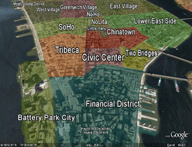
With two big players, TomTom/Tele Atlas and Nokia/NAVTEQ, dominating the worldwide basemap market, there's not much room for new players unless they are in niche markets. In what market is Maponics? Clement offers a GIS-friendly reply: "We see ourselves as the polygon company." His logic: It's easy to capture points; anyone can do that. And, Tele Atlas and NAVTEQ have a huge lead on the infrastructure required to create and maintain the key linear features, roads. That leaves what Clement calls the "most relevant" data, the "where am I?" data, the polygon that names a neighborhood or carrier route or other local area. Maponics can take advantage of that relevance, but also the fact that these and other polygon datasets are difficult to define. While GPSs and aerial imagery are very valuable for the collection of points of interest or street networks, those tools are not as helpful in finding neighborhood boundaries or other human social constructs. There's a whole different infrastructure and expertise required to create and update them.
Maponics claims to be the first data development company to deliver its entire neighborhood dataset via an API, including the full boundary coordinate stream. It certainly won't be the last to offer data and analytical tools that way. Clement expects to see a steady march in that direction by data companies worldwide.
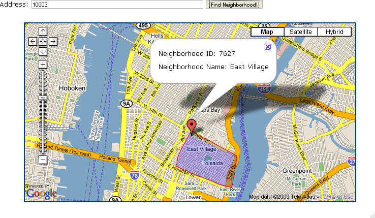 |
The API is what some might call a mix of a data service (subscribers have access to the data itself) and an analytical service (subscribers can perform attribute and spatial queries). The developer can, for example, ask for a list of neighborhoods closest to a location point, the neighborhood in which a point or address falls, a list of the neighborhoods within a city, ZIP Code or state, or the XML encoded latitude/longitude points that make up a neighborhood boundary surrounding a given address or location point. What is not delivered, Clement is quick to point out, is a mapping engine. The developer will typically use a client side rendering tool like Google Maps or Virtual Earth.
The development of the whole offering - from writing the API, to finding an external hosting service and bandwidth, to determining administration and pricing - took just a few months. While the API is rolling out in 2009, the idea and planning for it has gone on for some time. Customers, reports Clement, have been asking for something like this for many years. Part of the reason is the nature of Maponics customers. Few are "GIS" companies; instead they are involved in some other business (real estate, local search, wireless, social media) that needs to use the localized data, but not host it, update it or chunk it up into tiles.
 |
Clement recounts the history of Maponics (and many other data providers) data delivery: "tapes, CDs, DVDs, FTP..." On the receiving end were IT people loading data, building applications, and then updating data once per quarter. With the new API, Maponics data will still be updated quarterly; there'll just be no loading or updating! For now, Maponics has no plans to change its update schedule from quarterly, but will listen with care to what API clients request.
Pricing, at least at the outset, is not per transaction, but rather "all you can eat" based on which datasets and how much of the API are needed. Again, that strategy for the rollout is geared toward existing large Maponics customers. In the future, Clement notes, the company may look into transaction-based pricing for smaller users. How does Maponics expect to fair with the new offering? Clement is coy: "I expect there will be sufficient demand for the API services to be a good part of our 2009/2010 revenue."
Clement is not ready to write an obituary for physical media delivery for another few years. "Some clients have existing infrastructures [hardware and applications] that require them to stick to the traditional model of receiving and loading the data each quarter. Moving them to the new API, if and when they are ready, may take a few years." He suggests it may be two to three years until the overall market starts to expect all data providers to deliver via API.
With two big players, TomTom/Tele Atlas and Nokia/NAVTEQ, dominating the worldwide basemap market, there's not much room for new players unless they are in niche markets. In what market is Maponics? Clement offers a GIS-friendly reply: "We see ourselves as the polygon company." His logic: It's easy to capture points; anyone can do that. And, Tele Atlas and NAVTEQ have a huge lead on the infrastructure required to create and maintain the key linear features, roads. That leaves what Clement calls the "most relevant" data, the "where am I?" data, the polygon that names a neighborhood or carrier route or other local area. Maponics can take advantage of that relevance, but also the fact that these and other polygon datasets are difficult to define. While GPSs and aerial imagery are very valuable for the collection of points of interest or street networks, those tools are not as helpful in finding neighborhood boundaries or other human social constructs. There's a whole different infrastructure and expertise required to create and update them.
Maponics claims to be the first data development company to deliver its entire neighborhood dataset via an API, including the full boundary coordinate stream. It certainly won't be the last to offer data and analytical tools that way. Clement expects to see a steady march in that direction by data companies worldwide.
From Our Homepage
Saying Farewell to an Amazing Journey
Communicating with Maps
Is There a GIS Career Ladder?
What does it mean to be geospatially smart? Series
Ways Real Estate and Property Developers Utilize Melissa GeoData for Data-Driven Decisions
Unlocking Value From Daily Satellite Imagery and Insights
Maximizing the Value of Your Address Data with Geo Addressing
How Indoor Mapping Enhances the Security of Smart Buildings
Look Ahead: AI, Location Intelligence and Efficiency
Collaboration Takes on Sea Level Rise & Dynamic Technology Environments
Brownies for Brownfields
Has Everything Been Mapped Already?
How Is Data Literacy Changing in an Artificial Intelligence Landscape
Portfolios for GIS Professionals: More Than Just Maps
How to Create a Distance Matrix in QGIS - A Step-by-Step Guide
7 Ideas for Bringing GIS into the K-12 Classroom
The Geography of Movement