On January 11th Microsoft unveiled
MapPoint 2004 Fleet Edition to their MapPoint partners.This is not a
new product release, but rather a licensing and pricing re-structure
designed to give Microsoft partners more flexibility.
Key changes are:
MapPoint is part of an integrated structure of products that provides the tools for fleet management, sales force management or any application where multiple vehicles need to be tracked and mapped, and current attributes maintained about location, speed, time at stop, etc.
The product line extends to MapPoint Web Services, MapPoint Location Server, MapPoint 2004 and an SDK for both Web Services and Location Server.
The way it works can be through a black box that captures GPS data in a vehicle and then transfers it to MapPoint for display, GPS data captured via a cell phone, sent to Location Server and then to MapPoint for display, or a combination through third party software.
Because Microsoft is also involved in business intelligence, the tracking systems can be tied to the BI function, so status, fleet efficiencies and long term analysis can be done on fleet data.
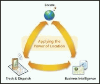
(From Microsoft MapPoint Fleet Presentation)
An example of third party software is ArtSoft's Comet Tracker, which is one of the comprehensive products for fleet tracking based on MapPoint 2004.Below is one of their custom interfaces for tracking, vehicle attribute capture and general or selective plotting.
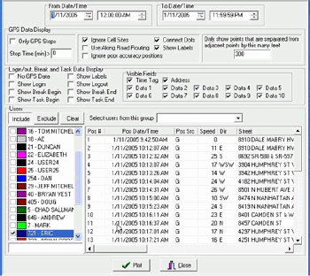
From Fleet Edition Microsoft Presentation by Tom Mitchell, CTO, ArtSoft, Inc.Click image for larger view.
Note that not only can the time window be selected, but groups of vehicles or sales people being tracked, and which of the data fields to be displayed, can be selected as well.This is in addition to the standard data of speed, directions and how long a vehicle has been stopped.
If you would like to know where a particular person is, look at "Where Is Steve," a unique and interesting application.We can see just where Steve Lombardi, the Microsoft "MapPoint Technical Evangelist," is located on any particular day.The MapPoint Web Services output of where Steve is looks like this.
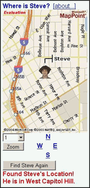
We also have basic map functionality of zoom and pan, and of course refresh, if Steve tries to slip away.
A very nice feature of MapPoint 2004 for the desktop is the speed at which it displays, refreshes and loads.Microsoft's target for display refresh is in the sub-second range, depending on the computer that it is running on.This can be a very nice feature if you are tracking a large number of vehicles and data refresh is frequently required.
Today, the ability to put in place a fleet management system is pretty straight forward.If your group has current GPS enabled cell phones, and you apply Microsoft Location Server, MapPoint 2004 will display those phone locations and all the usual GPS data.Of course, you could use Web Services in a manner like the "Where is Steve" application, and have the entire thing on the web.In any case, whether you are using a proprietary black box inside a vehicle or using cell phones, this new combination of less restrictive licensing and the infrastructure of web services and location server make MapPoint 2004 Fleet a very viable fleet management solution.
Key changes are:
- The per vehicle license requirement is removed
- Price modification reflect the more flexible licensing terms
- There is no longer a distinction between Real-time and Near Real-time.
- MapPoint 2004 may not be used to provide real-time vehicle guidance
- MapPoint 2004 cannot be used to calculate a route or order destinations based on the location of one vehicle.
MapPoint is part of an integrated structure of products that provides the tools for fleet management, sales force management or any application where multiple vehicles need to be tracked and mapped, and current attributes maintained about location, speed, time at stop, etc.
The product line extends to MapPoint Web Services, MapPoint Location Server, MapPoint 2004 and an SDK for both Web Services and Location Server.
The way it works can be through a black box that captures GPS data in a vehicle and then transfers it to MapPoint for display, GPS data captured via a cell phone, sent to Location Server and then to MapPoint for display, or a combination through third party software.
Because Microsoft is also involved in business intelligence, the tracking systems can be tied to the BI function, so status, fleet efficiencies and long term analysis can be done on fleet data.
(From Microsoft MapPoint Fleet Presentation)
An example of third party software is ArtSoft's Comet Tracker, which is one of the comprehensive products for fleet tracking based on MapPoint 2004.Below is one of their custom interfaces for tracking, vehicle attribute capture and general or selective plotting.
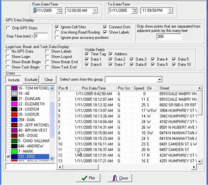
From Fleet Edition Microsoft Presentation by Tom Mitchell, CTO, ArtSoft, Inc.Click image for larger view.
Note that not only can the time window be selected, but groups of vehicles or sales people being tracked, and which of the data fields to be displayed, can be selected as well.This is in addition to the standard data of speed, directions and how long a vehicle has been stopped.
If you would like to know where a particular person is, look at "Where Is Steve," a unique and interesting application.We can see just where Steve Lombardi, the Microsoft "MapPoint Technical Evangelist," is located on any particular day.The MapPoint Web Services output of where Steve is looks like this.
We also have basic map functionality of zoom and pan, and of course refresh, if Steve tries to slip away.
A very nice feature of MapPoint 2004 for the desktop is the speed at which it displays, refreshes and loads.Microsoft's target for display refresh is in the sub-second range, depending on the computer that it is running on.This can be a very nice feature if you are tracking a large number of vehicles and data refresh is frequently required.
Today, the ability to put in place a fleet management system is pretty straight forward.If your group has current GPS enabled cell phones, and you apply Microsoft Location Server, MapPoint 2004 will display those phone locations and all the usual GPS data.Of course, you could use Web Services in a manner like the "Where is Steve" application, and have the entire thing on the web.In any case, whether you are using a proprietary black box inside a vehicle or using cell phones, this new combination of less restrictive licensing and the infrastructure of web services and location server make MapPoint 2004 Fleet a very viable fleet management solution.
From Our Homepage
Saying Farewell to an Amazing Journey
Communicating with Maps
Is There a GIS Career Ladder?
What does it mean to be geospatially smart? Series
Ways Real Estate and Property Developers Utilize Melissa GeoData for Data-Driven Decisions
Unlocking Value From Daily Satellite Imagery and Insights
Maximizing the Value of Your Address Data with Geo Addressing
How Indoor Mapping Enhances the Security of Smart Buildings
Look Ahead: AI, Location Intelligence and Efficiency
Collaboration Takes on Sea Level Rise & Dynamic Technology Environments
Brownies for Brownfields
Has Everything Been Mapped Already?
How Is Data Literacy Changing in an Artificial Intelligence Landscape
Portfolios for GIS Professionals: More Than Just Maps
How to Create a Distance Matrix in QGIS - A Step-by-Step Guide
7 Ideas for Bringing GIS into the K-12 Classroom
The Geography of Movement