Mid
Suffolk District Council (MSDC), in support of e-government policy,
implemented
Mid Suffolk Mapping within their web portal, allowing public access to
spatial
information about the area.They also implemented an intranet-based
mapping
system for the delivery of a wide range of map-based information to any
Council
officer who needed it.
What is e-government policy?
e-government is a national strategy that has been launched across the United Kingdom to ensure that all local and central government services should be made electronically available by 2005.This should include such services as paying council tax, claiming benefits and pensions, and requesting repairs online.By exploiting the power of information and communications technology it is hoped to transform accessibility, quality and cost effectiveness of public services.Over 80% of information stored and used by Local Authorities is related to spatial data.This makes GIS a powerful tool.More than ever before there is a requirement to share and use information within and across departments more efficiently.What one department finds useful may also be beneficial to another.The central idea of e-government is to ensure that information is made available to staff and customers alike, when and where they want it.
MSDC wanted a cost effective, easy-to-use, real-time system of computerised map-based information that could be accessed by Council officers with little internal training and an internet site within the Council's web portal that could be used by members of the public who had no previous training or experience in GIS software.
MSDC had been using SIA's standard dataMAP GIS product for a number of years and were keen to extend it to their intranet.Following on from this, SIA developed the dataMAP GIS Internet Browser, beginning with a simplified version of the Intranet Browser.This was done in close partnership with MSDC, so that the new product was suitable for both MSDC's immediate needs and also flexible enough to meet the needs of a wide range of other organisations.This new internet resource would lend itself well to members of the public with no knowledge of GIS and give them access to information about an area of interest.
A fast, cost-effective and easy-to-use service is now being provided via the intranet to every member of the Council staff requiring it and via the internet to MSDC residents or anyone with an interest in Mid Suffolk.The user interfaces are simple to use, which has minimised staff training for Council members and simple on screen help is provided for internet users new to GIS.
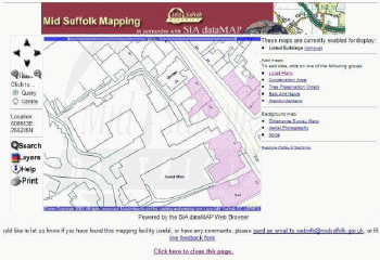
dataMAP GIS Internet Browser.Click image for larger view.
In relation to the intranet browser, a combination of base mapping with overlays of appropriate user information is being delivered in real time. Various departments have found the browser valuable.Pest Control, Council Tax and Benefits officers all use the system as a locator for properties they need to visit.Also the Planning and Environmental Health department are able to access information relevant to their areas of work.Those in the Private Sector Housing, use it to find whether a property for which a housing repair grant has been applied for is a listed building.As the intranet browser was being developed, SIA incorporated client suggestions for improvements into the product.This co-operation lead to the delivery of map-based information to the public via the internet site.
According to Linda Bestow of the Mid Suffolk District Council, "SIA were able to accommodate our very tight deadlines for this project to enable the mapping to be incorporated in our new website.The system was easy to install and has good on-screen administration tools to customise and change the information displayed as and when we need too.Customer feedback has been excellent and the mapping portal has become the most visited part of the Council's website."
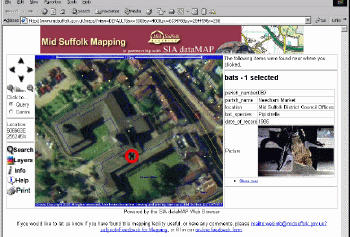
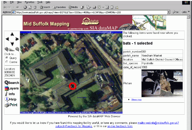
dataMAP GIS Intranet Browser. Click image for larger view.
The public now have the opportunity to pinpoint any property in the District, and discover if there are any bats in their belfry or greater crested newts in the garden! The whole of the Local Plan information together with the Listed Building and Conservation area datasets are also provided.Aerial photographs can also be used as a background.As the user zooms in or out, the map background changes seamlessly to an appropriate level of detail, ranging from 1:2500 through 1:10,000 to 1:50,000 scale.
The Future
Work is now in progress on the next phase of the project, which is to capture more layers of information useful to the public, for example locations of facilities such as libraries, schools and re-cycling centres.SIA also intends to add a "find my nearest" facility.
What is e-government policy?
e-government is a national strategy that has been launched across the United Kingdom to ensure that all local and central government services should be made electronically available by 2005.This should include such services as paying council tax, claiming benefits and pensions, and requesting repairs online.By exploiting the power of information and communications technology it is hoped to transform accessibility, quality and cost effectiveness of public services.Over 80% of information stored and used by Local Authorities is related to spatial data.This makes GIS a powerful tool.More than ever before there is a requirement to share and use information within and across departments more efficiently.What one department finds useful may also be beneficial to another.The central idea of e-government is to ensure that information is made available to staff and customers alike, when and where they want it.
MSDC wanted a cost effective, easy-to-use, real-time system of computerised map-based information that could be accessed by Council officers with little internal training and an internet site within the Council's web portal that could be used by members of the public who had no previous training or experience in GIS software.
MSDC had been using SIA's standard dataMAP GIS product for a number of years and were keen to extend it to their intranet.Following on from this, SIA developed the dataMAP GIS Internet Browser, beginning with a simplified version of the Intranet Browser.This was done in close partnership with MSDC, so that the new product was suitable for both MSDC's immediate needs and also flexible enough to meet the needs of a wide range of other organisations.This new internet resource would lend itself well to members of the public with no knowledge of GIS and give them access to information about an area of interest.
A fast, cost-effective and easy-to-use service is now being provided via the intranet to every member of the Council staff requiring it and via the internet to MSDC residents or anyone with an interest in Mid Suffolk.The user interfaces are simple to use, which has minimised staff training for Council members and simple on screen help is provided for internet users new to GIS.

dataMAP GIS Internet Browser.Click image for larger view.
In relation to the intranet browser, a combination of base mapping with overlays of appropriate user information is being delivered in real time. Various departments have found the browser valuable.Pest Control, Council Tax and Benefits officers all use the system as a locator for properties they need to visit.Also the Planning and Environmental Health department are able to access information relevant to their areas of work.Those in the Private Sector Housing, use it to find whether a property for which a housing repair grant has been applied for is a listed building.As the intranet browser was being developed, SIA incorporated client suggestions for improvements into the product.This co-operation lead to the delivery of map-based information to the public via the internet site.
According to Linda Bestow of the Mid Suffolk District Council, "SIA were able to accommodate our very tight deadlines for this project to enable the mapping to be incorporated in our new website.The system was easy to install and has good on-screen administration tools to customise and change the information displayed as and when we need too.Customer feedback has been excellent and the mapping portal has become the most visited part of the Council's website."
dataMAP GIS Intranet Browser. Click image for larger view.
The public now have the opportunity to pinpoint any property in the District, and discover if there are any bats in their belfry or greater crested newts in the garden! The whole of the Local Plan information together with the Listed Building and Conservation area datasets are also provided.Aerial photographs can also be used as a background.As the user zooms in or out, the map background changes seamlessly to an appropriate level of detail, ranging from 1:2500 through 1:10,000 to 1:50,000 scale.
The Future
Work is now in progress on the next phase of the project, which is to capture more layers of information useful to the public, for example locations of facilities such as libraries, schools and re-cycling centres.SIA also intends to add a "find my nearest" facility.
From Our Homepage
Saying Farewell to an Amazing Journey
Communicating with Maps
Is There a GIS Career Ladder?
What does it mean to be geospatially smart? Series
Ways Real Estate and Property Developers Utilize Melissa GeoData for Data-Driven Decisions
Unlocking Value From Daily Satellite Imagery and Insights
Maximizing the Value of Your Address Data with Geo Addressing
How Indoor Mapping Enhances the Security of Smart Buildings
Look Ahead: AI, Location Intelligence and Efficiency
Collaboration Takes on Sea Level Rise & Dynamic Technology Environments
Brownies for Brownfields
Has Everything Been Mapped Already?
How Is Data Literacy Changing in an Artificial Intelligence Landscape
Portfolios for GIS Professionals: More Than Just Maps
How to Create a Distance Matrix in QGIS - A Step-by-Step Guide
7 Ideas for Bringing GIS into the K-12 Classroom
The Geography of Movement