The dependence of rural communities on the land that
supports them creates challenges to maintaining a desirable quality of
life, environmental health and economic competitiveness that often are
further hampered by an inadequate information technology
infrastructure.The National
Association for Rural Geospatial Innovations in America likens the
situation to what rural America faced in the 1930's that led to the
establishment of the Rural Electrification Act of 1936.
Mississippi is addressing its "rural challenges" head-on by
establishing themselves as a Location Aware Enterprise.
In our first three articles on the Location Aware Enterprise (1, 2, 3), we described the elements necessary for making location information technologies a powerful integrating force in improved decision making and stronger business results.In this fourth article, we showcase Mississippi as a model Location Aware Enterprise as it moves forward to leverage geospatial resources for bringing new and enhanced capabilities in public safety and homeland security, state revenue generation and natural resource planning and maintenance.Mississippi is already seeing how their "geo-lectrification" through a Location Aware Enterprise is having a profound affect on the way state agencies work together and with local jurisdictions to improve the way of life and economy for all citizens in the state.
In our first article on the Location Aware Enterprise we introduced five service areas.
Making partnerships work: Mississippi establishes a coordinating council
In order to ensure the most effective use of limited resources, the State Legislature in July 2003 established the Mississippi Coordinating Council for Remote Sensing and Geographic Information Systems.The state recognized the importance of having senior decision makers from all government service areas involved in the policy and standards setting processes.Therefore, the members of the Council include the Executive Directors of the various State departments as well as county and local representatives.The legislature also established a Policy Advisory Committee (PAC) and a Technical Users Group (TUG) to support the efforts of the Council.
Among the first significant actions of the Council is developing a standardized addressing policy for the State.A standardized addressing system will be a fundamental underpinning to a variety of applications including public safety and fraud detection.Without a coordinated effort, this critical component of spatially-enabled statewide services could not exist.
Enterprise approach to spatially-enabled IT infrastructure: Mississippi commits itself to a GIS clearinghouse
In November 2002, Governor Ronnie Musgroves' Advisory Commission on Remote Sensing Technologies recommended the state develop the Mississippi Digital Earth Model (MDEM).When complete, this digital land base computer model of the state will be the foundational geospatial element of the statewide IT infrastructure.The Department of Environmental Quality is responsible for coordinating the acquisition and maintenance of the data, while the Department of Information Technology Services is responsible for storing, managing and providing access to the data through a statewide GIS clearinghouse. This partnership between a functional state agency and the state IT department ensures Mississippi's statewide IT infrastructure is spatially enabled, rather than seeing stove-piped geospatial systems develop.
Information underpinning to location-enabled applications: Mississippi moves to agree on a geo-addressing standard
The rubber meets the road when geospatial data is used for critical lifesaving applications.In Mississippi there is a clear need to establish USPS/E911 compliant addressing.At the moment, only a handful of Mississippi's 82 counties are E911 ready and a large part of the problem can be linked directly to lack of compliant addressing.The most likely solution will involve applying a common identifier, such as a US National Grid coordinate, to all addresses while still allowing the various counties to maintain their established addressing protocols.The Addressing Standards Sub-Committee is trying to be reasonable, realistic and responsible as it considers various options. Finding a common reference system to which all of the existing addressing strategies may be mapped is critical to consensus building on statewide applications of location technology resources.
Making government responsive: Mississippi looks to leverage its new geospatial resources for improving public health and safety
Mississippi fully expects to realize significant gains in a variety of areas through the shared, standardized and coordinated application of geospatial resources.Emergency Management, Public Safety and Fire Services will all benefit directly both through enhanced E911 services and the introduction of location aware vehicle routing systems.The State Veterinarian's Office and the Mississippi Board of Animal Health will be significantly helped in the implementation of the USDA's National Premise Identification System and the National Animal Identification System, both of which are fundamental to animal disease tracking and surveillance and to managing biological events which may be the result of terrorist activities.
The Mississippi Department of Human Services will use geospatial technology to detect and control fraudulent use of welfare funds.The Mississippi Department of Homeland Security is already maintaining location based critical infrastructure databases.Mississippi is an evacuation destination for New Orleans, Florida and many Gulf Coast communities when they are threatened by hurricanes.An enhanced Evacuation Shelter Management system will assist the public in identifying shelters which offer the facilities they need, give them the ability to map an appropriate route to the shelter from their home and provide information about the location of adjacent shelters capable of caring for their animals.
As the Rural Electrification Act brought city conveniences, such as electric lighting and radio, to rural areas, Mississippi is counting on their Location Aware Enterprise to improve the standard of living in the state by making it a safer and more desirable location to live and work.The state has already seen significant economic benefits of using geospatial data when the Mississippi Development Authority used GIS to convince Nissan to build a $930 million manufacturing plant in Jackson, which also brought in seven tier-one Nissan suppliers to the Metro Jackson area.Now, with their commitment to coordination and their plans for embedding state-wide geospatial resources in critical public safety, homeland security, and revenue generating applications they will prove the hypothesis of the Location Aware Enterprise as a powerful integrating force for making better and faster decisions and achieving stronger business results.
In our first three articles on the Location Aware Enterprise (1, 2, 3), we described the elements necessary for making location information technologies a powerful integrating force in improved decision making and stronger business results.In this fourth article, we showcase Mississippi as a model Location Aware Enterprise as it moves forward to leverage geospatial resources for bringing new and enhanced capabilities in public safety and homeland security, state revenue generation and natural resource planning and maintenance.Mississippi is already seeing how their "geo-lectrification" through a Location Aware Enterprise is having a profound affect on the way state agencies work together and with local jurisdictions to improve the way of life and economy for all citizens in the state.
In our first article on the Location Aware Enterprise we introduced five service areas.
- Organizational design and change management
- Enterprise architecture
- Information architecture and knowledge management
- Analysis and visualization
- Economic business analysis
- Organizational design - making partnerships work in the state through a commitment to coordination
- Enterprise architecture - developing an enterprise approach to spatially enabling their IT infrastructure
- Information architecture - developing a state-wide information architecture for addressing, which will underpin key public safety/homeland security and revenue generating business applications
- Analysis and visualization - developing concepts for new location-enabled applications in E911, bio-terrorism and fraud detection that will have real impact to the health and well-being of citizens in the state
Making partnerships work: Mississippi establishes a coordinating council
In order to ensure the most effective use of limited resources, the State Legislature in July 2003 established the Mississippi Coordinating Council for Remote Sensing and Geographic Information Systems.The state recognized the importance of having senior decision makers from all government service areas involved in the policy and standards setting processes.Therefore, the members of the Council include the Executive Directors of the various State departments as well as county and local representatives.The legislature also established a Policy Advisory Committee (PAC) and a Technical Users Group (TUG) to support the efforts of the Council.
Among the first significant actions of the Council is developing a standardized addressing policy for the State.A standardized addressing system will be a fundamental underpinning to a variety of applications including public safety and fraud detection.Without a coordinated effort, this critical component of spatially-enabled statewide services could not exist.
Enterprise approach to spatially-enabled IT infrastructure: Mississippi commits itself to a GIS clearinghouse
In November 2002, Governor Ronnie Musgroves' Advisory Commission on Remote Sensing Technologies recommended the state develop the Mississippi Digital Earth Model (MDEM).When complete, this digital land base computer model of the state will be the foundational geospatial element of the statewide IT infrastructure.The Department of Environmental Quality is responsible for coordinating the acquisition and maintenance of the data, while the Department of Information Technology Services is responsible for storing, managing and providing access to the data through a statewide GIS clearinghouse. This partnership between a functional state agency and the state IT department ensures Mississippi's statewide IT infrastructure is spatially enabled, rather than seeing stove-piped geospatial systems develop.
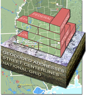 |
| Figure 1.The MDEM will be the
geospatial foundation for the statewide IT infrastructure.Source: Booz
Allen Hamilton. |
Information underpinning to location-enabled applications: Mississippi moves to agree on a geo-addressing standard
The rubber meets the road when geospatial data is used for critical lifesaving applications.In Mississippi there is a clear need to establish USPS/E911 compliant addressing.At the moment, only a handful of Mississippi's 82 counties are E911 ready and a large part of the problem can be linked directly to lack of compliant addressing.The most likely solution will involve applying a common identifier, such as a US National Grid coordinate, to all addresses while still allowing the various counties to maintain their established addressing protocols.The Addressing Standards Sub-Committee is trying to be reasonable, realistic and responsible as it considers various options. Finding a common reference system to which all of the existing addressing strategies may be mapped is critical to consensus building on statewide applications of location technology resources.
Making government responsive: Mississippi looks to leverage its new geospatial resources for improving public health and safety
Mississippi fully expects to realize significant gains in a variety of areas through the shared, standardized and coordinated application of geospatial resources.Emergency Management, Public Safety and Fire Services will all benefit directly both through enhanced E911 services and the introduction of location aware vehicle routing systems.The State Veterinarian's Office and the Mississippi Board of Animal Health will be significantly helped in the implementation of the USDA's National Premise Identification System and the National Animal Identification System, both of which are fundamental to animal disease tracking and surveillance and to managing biological events which may be the result of terrorist activities.
The Mississippi Department of Human Services will use geospatial technology to detect and control fraudulent use of welfare funds.The Mississippi Department of Homeland Security is already maintaining location based critical infrastructure databases.Mississippi is an evacuation destination for New Orleans, Florida and many Gulf Coast communities when they are threatened by hurricanes.An enhanced Evacuation Shelter Management system will assist the public in identifying shelters which offer the facilities they need, give them the ability to map an appropriate route to the shelter from their home and provide information about the location of adjacent shelters capable of caring for their animals.
As the Rural Electrification Act brought city conveniences, such as electric lighting and radio, to rural areas, Mississippi is counting on their Location Aware Enterprise to improve the standard of living in the state by making it a safer and more desirable location to live and work.The state has already seen significant economic benefits of using geospatial data when the Mississippi Development Authority used GIS to convince Nissan to build a $930 million manufacturing plant in Jackson, which also brought in seven tier-one Nissan suppliers to the Metro Jackson area.Now, with their commitment to coordination and their plans for embedding state-wide geospatial resources in critical public safety, homeland security, and revenue generating applications they will prove the hypothesis of the Location Aware Enterprise as a powerful integrating force for making better and faster decisions and achieving stronger business results.
From Our Homepage
Saying Farewell to an Amazing Journey
Communicating with Maps
Is There a GIS Career Ladder?
What does it mean to be geospatially smart? Series
Ways Real Estate and Property Developers Utilize Melissa GeoData for Data-Driven Decisions
Unlocking Value From Daily Satellite Imagery and Insights
Maximizing the Value of Your Address Data with Geo Addressing
How Indoor Mapping Enhances the Security of Smart Buildings
Look Ahead: AI, Location Intelligence and Efficiency
Collaboration Takes on Sea Level Rise & Dynamic Technology Environments
Brownies for Brownfields
Has Everything Been Mapped Already?
How Is Data Literacy Changing in an Artificial Intelligence Landscape
Portfolios for GIS Professionals: More Than Just Maps
How to Create a Distance Matrix in QGIS - A Step-by-Step Guide
7 Ideas for Bringing GIS into the K-12 Classroom
The Geography of Movement