Australia's
deadliest natural disaster in history - the 2009 Victoria bushfires -
resulted in terrible loss of life and property. On February 7, the "Black Saturday bushfires"
ignited and burned across the Australian state of Victoria. The
combination of triple-digit heat, high winds and more than 10 years of
drought produced the worst wildfire conditions in the country's
history. Dozens of fires erupted across Victoria. These separate fires
merged into a single, enormous blaze called the Kinglake Complex. More
than 170 people perished as a result of the fires, and more than 400
were injured.
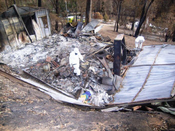
Immediately after the wildfires swept through the area, the Victoria Police Department (VicPD) began damage assessment. This included searching for survivors and those who had lost their lives. Searching through the wreckage and rubble was no easy task. Whole communities were destroyed. Streets, businesses, schools, homes and other landmarks were turned to ash and cinder. The fires had destroyed more than 700 square miles. With each passing hour, more people were reported missing or deceased.
Accurate information was at a premium during the initial response phase of the wildfires. As response moved into recovery and assessment, law enforcement, emergency commanders and others needed the ability to quickly go into the field and accurately capture the extent of the damage.
As the wildfires grew in intensity and scale, several companies around the world offered assistance, including ESRI. "ESRI President Jack Dangermond reached out to the Australia ESRI office and offered support," said Russ Johnson, director of the ESRI public safety division. "We sent Tom Patterson, our wildfire industry manager, to work with ESRI Australia Pty. Ltd. to help with whatever the organizations and agencies needed."
The Mapping and Planning Support Unit
Victoria police had never carried out such a large-scale emergency damage assessment. They looked at their current assessment tools - paper maps, forms and binders - and recognized the dilemma. They had an overwhelming amount of terrain to cover, and time was paramount; people needed to know as quickly as possible exactly how bad the situation was. Patterson was on hand offering technical assistance and expertise. A retired fire chief, Patterson had decades of experience in all phases of wildfire management. Still, the Victoria fires were an entirely unique experience for everyone involved.
"Authorities had to search every property within a 550,000-acre perimeter where someone could have taken shelter," said Patterson. "They did a quick analysis of the number of properties with structures; there were more than 8,000, and they thought it was going to take months to complete the assessment on the ground."
To boost search accuracy and speed, VicPD contacted the Australian Capital Territory Emergency Services Agency. That organization had recently set up the Mapping and Planning Support (MAPS) unit. Composed of government and private-sector GIS professionals, the unit is the only one in the country specifically designed to execute large-scale disaster management operations.
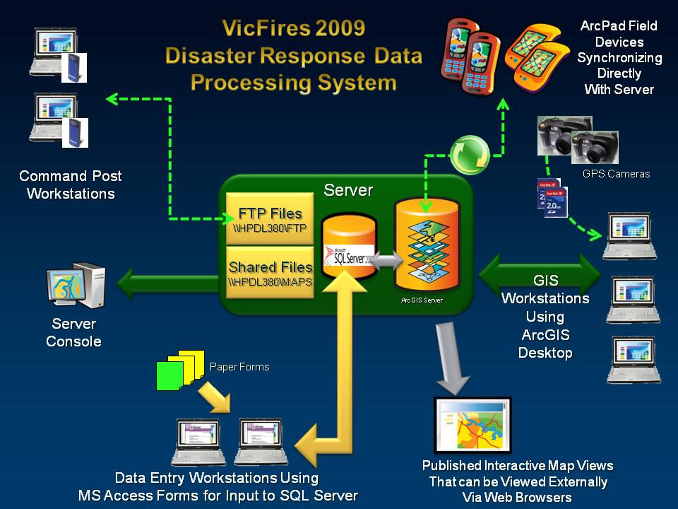
MAPS arrived on the scene with laptops loaded with ArcGIS software and wireless communication modems. Each team had a lead GIS specialist and five to seven GIS technicians. The teams worked 12- to 18-hour shifts for five days, and then would be replaced by another team. One day of overlap was scheduled to ensure consistency during the transition. For 43 days, the MAPS team helped carry out the search operations. Over 40 GIS personnel worked 3,600 total hours (306 work days).
The Australia-based GIS company, Maptel, an ESRI business partner, jumped into the fray of operations to assist with GIS software and services. Maptel worked with Trimble Navigation and Motorola to secure ruggedized PDAs loaded with ArcPad 8 mobile GIS software. Maptel programmers developed a custom ArcPad damage assessment applet that displayed the same Rapid Impact Assessment (Premises) paper form commonly used by VicPD. The digital applet automatically linked to parcel data.
The public safety division of ESRI, working through Patterson, supplied software, services and expertise. ESRI Australia supplied ArcGIS licenses as well as additional computer hardware, including rugged Getac laptops and Toshiba notebooks. ESRI's Professional Services provided support.
The New Search: Operation Royals
In mid-February, Victoria Police were directed to expand the search to every single property within the Kinglake Complex fire perimeter. This was a result of the growing number of casualties discovered during the initial phases of the search. As more people were reported missing or deceased, commanders recognized the likelihood of even more fatalities.
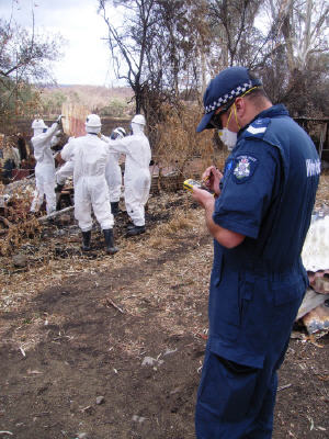
The new search would be more comprehensive and would involve searching any and all areas where someone could have sought shelter during the fires. Designated "Operation Royals," the new search involved the Australian Defence Force, Australian Federal Police, and VicPD. Approximately 200 personnel, organized into five-person search teams each led by a Victoria Police team leader, would have an even greater area to cover and more documentation requirements to perform in the field.
Teams had to inspect every property driveway, extending to 50 meters on either side, from the road to the house. In addition, staff members searched 50 meters around each residence and outbuilding. Large mechanical excavators were used to remove fallen debris and corrugated roofing to supply a comprehensive view of the ground.
Prior to GIS, the old method for documenting property searches was manual. A team leader would certify that the property had been properly cleared by filling out a color-coded paper form: green for residences and yellow for outbuildings, vehicles, tanks, mine shafts, drainages and so forth - anywhere someone could possibly hide to escape the inferno.
A green tag would be placed in plain view of the property to indicate it had been thoroughly searched. A red tag would be placed if possible remains were discovered.
Search crews had GPS units loaded with NAVTEQ street map data and Ricoh GPS-enabled digital cameras to record and photograph findings. Every night, staff members from the Rescue Coordination Center drove the 150-kilometer round-trip to the incident command post in Kinglake to retrieve forms and take the memory cards for each camera. They would then manually type newly captured data from the forms into the database. The updated database would then be used to generate search maps depicting areas searched and areas yet to be searched.
This method of search and data capture was effective, but newly developed mobile technology offered the possibility of even more effective capture which would allow users in the field to instantly send updates back to the command center database. Centrally updated information would then be sent wirelessly back to every individual operating in the field.
"I had no problems adapting to the hand-held device," said Lachlan Holding, acting sergeant in the Victoria Police Department. "It saved me heaps of time during one of the worst natural disasters our country has ever seen."
Maptel developed a completely new password-protected applet using a custom ArcPad 8 applet that included additional search criteria ordered by the coroner. Officers successfully field-tested the ArcPad applet. The new method saved time; users simply tapped on the screen, selected items from the drop-down menus, and updated search data with a few menu clicks.
In addition to the application's yellow and green indicators for properties searched and not searched, a built-in GPS ensured they could see they were in the correct parcel designated for a search. The applet made certain that a person would not advance to the next screen unless all the required information had been entered.
"It just makes things so much easier," said Shane Morton, leading senior constable for the Victoria Police Department. "Being able to simplify the process and make it so fast was just fantastic."
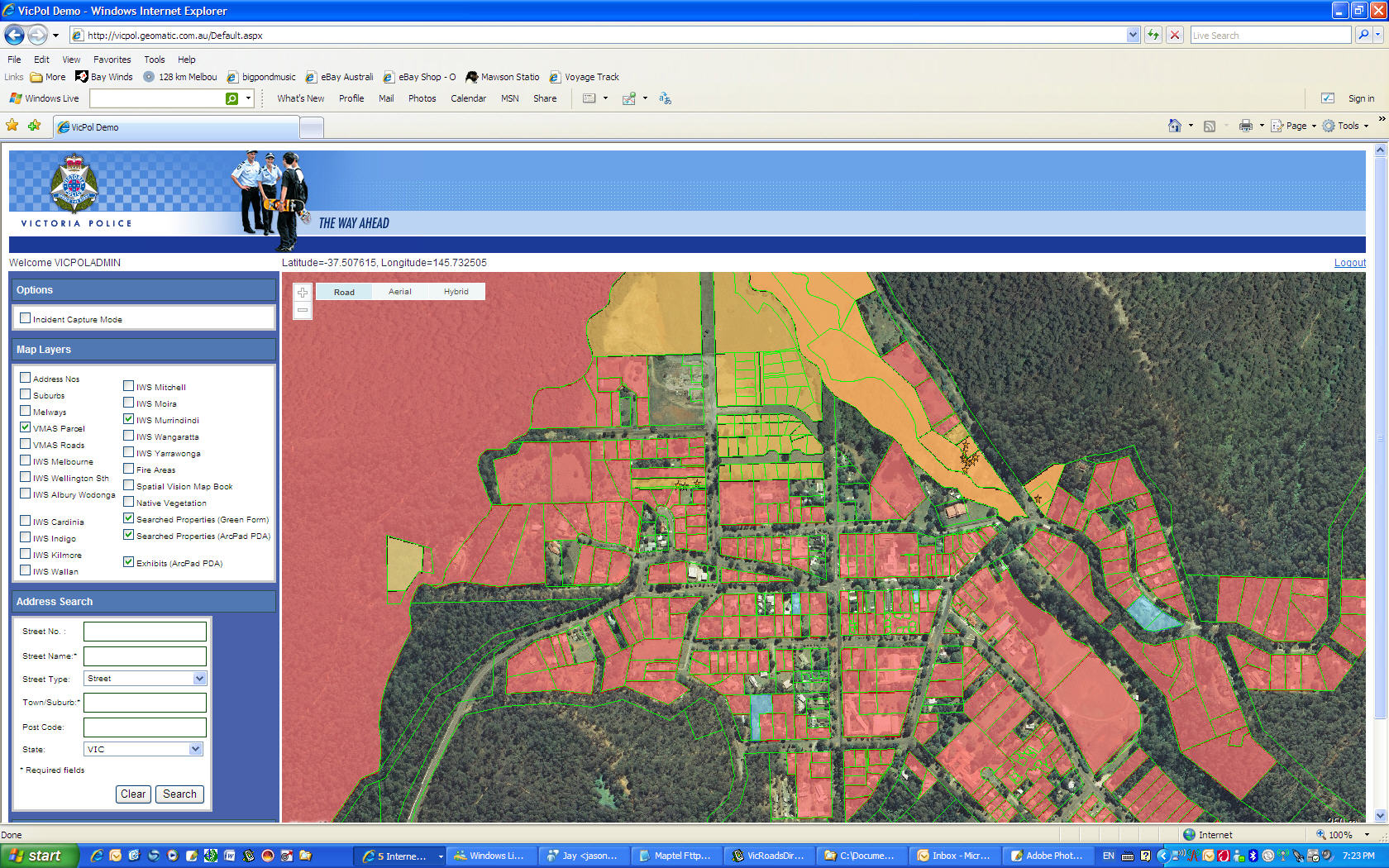
New information was easily integrated into the VicPD Web mapping site using a Web Map Server feed. With the click of a button, a user in the field synchronized data collected in the mobile device with ArcGIS Server running in the Rescue Coordination Center. Search managers monitored field searches on a continuous basis with dynamic data constantly coming into command centers and in turn updated in all mobile devices in the field.
In just under three weeks, nearly 5,800 properties were searched. Another 3,300 searches were performed for nearby buildings, sheds, vehicles and water tanks. More than 1,500 records related to casualties, fire damage and property assessment were collected using ArcPad 8 and transmitted via the 3G cellular network to the server at the Rescue Coordination Center. Trying to capture, send out, integrate and manage these records using manual methods would have been a time consuming, cumbersome process. Mobile GIS, with real-time wireless data transfer, streamlined the process.
"Once firefighting operations went into recovery and damage assessment, the search became an absolute top priority," said Johnson. "I think the work of the Australian government, including the Victoria Police and the MAPS unit and the dozens of other assisting agencies, was invaluable in this effort."
 |
 |
Immediately after the wildfires swept through the area, the Victoria Police Department (VicPD) began damage assessment. This included searching for survivors and those who had lost their lives. Searching through the wreckage and rubble was no easy task. Whole communities were destroyed. Streets, businesses, schools, homes and other landmarks were turned to ash and cinder. The fires had destroyed more than 700 square miles. With each passing hour, more people were reported missing or deceased.
Accurate information was at a premium during the initial response phase of the wildfires. As response moved into recovery and assessment, law enforcement, emergency commanders and others needed the ability to quickly go into the field and accurately capture the extent of the damage.
As the wildfires grew in intensity and scale, several companies around the world offered assistance, including ESRI. "ESRI President Jack Dangermond reached out to the Australia ESRI office and offered support," said Russ Johnson, director of the ESRI public safety division. "We sent Tom Patterson, our wildfire industry manager, to work with ESRI Australia Pty. Ltd. to help with whatever the organizations and agencies needed."
The Mapping and Planning Support Unit
Victoria police had never carried out such a large-scale emergency damage assessment. They looked at their current assessment tools - paper maps, forms and binders - and recognized the dilemma. They had an overwhelming amount of terrain to cover, and time was paramount; people needed to know as quickly as possible exactly how bad the situation was. Patterson was on hand offering technical assistance and expertise. A retired fire chief, Patterson had decades of experience in all phases of wildfire management. Still, the Victoria fires were an entirely unique experience for everyone involved.
"Authorities had to search every property within a 550,000-acre perimeter where someone could have taken shelter," said Patterson. "They did a quick analysis of the number of properties with structures; there were more than 8,000, and they thought it was going to take months to complete the assessment on the ground."
To boost search accuracy and speed, VicPD contacted the Australian Capital Territory Emergency Services Agency. That organization had recently set up the Mapping and Planning Support (MAPS) unit. Composed of government and private-sector GIS professionals, the unit is the only one in the country specifically designed to execute large-scale disaster management operations.
MAPS arrived on the scene with laptops loaded with ArcGIS software and wireless communication modems. Each team had a lead GIS specialist and five to seven GIS technicians. The teams worked 12- to 18-hour shifts for five days, and then would be replaced by another team. One day of overlap was scheduled to ensure consistency during the transition. For 43 days, the MAPS team helped carry out the search operations. Over 40 GIS personnel worked 3,600 total hours (306 work days).
The Australia-based GIS company, Maptel, an ESRI business partner, jumped into the fray of operations to assist with GIS software and services. Maptel worked with Trimble Navigation and Motorola to secure ruggedized PDAs loaded with ArcPad 8 mobile GIS software. Maptel programmers developed a custom ArcPad damage assessment applet that displayed the same Rapid Impact Assessment (Premises) paper form commonly used by VicPD. The digital applet automatically linked to parcel data.
The public safety division of ESRI, working through Patterson, supplied software, services and expertise. ESRI Australia supplied ArcGIS licenses as well as additional computer hardware, including rugged Getac laptops and Toshiba notebooks. ESRI's Professional Services provided support.
The New Search: Operation Royals
In mid-February, Victoria Police were directed to expand the search to every single property within the Kinglake Complex fire perimeter. This was a result of the growing number of casualties discovered during the initial phases of the search. As more people were reported missing or deceased, commanders recognized the likelihood of even more fatalities.
The new search would be more comprehensive and would involve searching any and all areas where someone could have sought shelter during the fires. Designated "Operation Royals," the new search involved the Australian Defence Force, Australian Federal Police, and VicPD. Approximately 200 personnel, organized into five-person search teams each led by a Victoria Police team leader, would have an even greater area to cover and more documentation requirements to perform in the field.
Teams had to inspect every property driveway, extending to 50 meters on either side, from the road to the house. In addition, staff members searched 50 meters around each residence and outbuilding. Large mechanical excavators were used to remove fallen debris and corrugated roofing to supply a comprehensive view of the ground.
 |
Prior to GIS, the old method for documenting property searches was manual. A team leader would certify that the property had been properly cleared by filling out a color-coded paper form: green for residences and yellow for outbuildings, vehicles, tanks, mine shafts, drainages and so forth - anywhere someone could possibly hide to escape the inferno.
A green tag would be placed in plain view of the property to indicate it had been thoroughly searched. A red tag would be placed if possible remains were discovered.
Search crews had GPS units loaded with NAVTEQ street map data and Ricoh GPS-enabled digital cameras to record and photograph findings. Every night, staff members from the Rescue Coordination Center drove the 150-kilometer round-trip to the incident command post in Kinglake to retrieve forms and take the memory cards for each camera. They would then manually type newly captured data from the forms into the database. The updated database would then be used to generate search maps depicting areas searched and areas yet to be searched.
This method of search and data capture was effective, but newly developed mobile technology offered the possibility of even more effective capture which would allow users in the field to instantly send updates back to the command center database. Centrally updated information would then be sent wirelessly back to every individual operating in the field.
"I had no problems adapting to the hand-held device," said Lachlan Holding, acting sergeant in the Victoria Police Department. "It saved me heaps of time during one of the worst natural disasters our country has ever seen."
Maptel developed a completely new password-protected applet using a custom ArcPad 8 applet that included additional search criteria ordered by the coroner. Officers successfully field-tested the ArcPad applet. The new method saved time; users simply tapped on the screen, selected items from the drop-down menus, and updated search data with a few menu clicks.
In addition to the application's yellow and green indicators for properties searched and not searched, a built-in GPS ensured they could see they were in the correct parcel designated for a search. The applet made certain that a person would not advance to the next screen unless all the required information had been entered.
"It just makes things so much easier," said Shane Morton, leading senior constable for the Victoria Police Department. "Being able to simplify the process and make it so fast was just fantastic."
New information was easily integrated into the VicPD Web mapping site using a Web Map Server feed. With the click of a button, a user in the field synchronized data collected in the mobile device with ArcGIS Server running in the Rescue Coordination Center. Search managers monitored field searches on a continuous basis with dynamic data constantly coming into command centers and in turn updated in all mobile devices in the field.
 |
In just under three weeks, nearly 5,800 properties were searched. Another 3,300 searches were performed for nearby buildings, sheds, vehicles and water tanks. More than 1,500 records related to casualties, fire damage and property assessment were collected using ArcPad 8 and transmitted via the 3G cellular network to the server at the Rescue Coordination Center. Trying to capture, send out, integrate and manage these records using manual methods would have been a time consuming, cumbersome process. Mobile GIS, with real-time wireless data transfer, streamlined the process.
 |
"Once firefighting operations went into recovery and damage assessment, the search became an absolute top priority," said Johnson. "I think the work of the Australian government, including the Victoria Police and the MAPS unit and the dozens of other assisting agencies, was invaluable in this effort."
From Our Homepage
Saying Farewell to an Amazing Journey
Communicating with Maps
Is There a GIS Career Ladder?
What does it mean to be geospatially smart? Series
Ways Real Estate and Property Developers Utilize Melissa GeoData for Data-Driven Decisions
Unlocking Value From Daily Satellite Imagery and Insights
Maximizing the Value of Your Address Data with Geo Addressing
How Indoor Mapping Enhances the Security of Smart Buildings
Look Ahead: AI, Location Intelligence and Efficiency
Collaboration Takes on Sea Level Rise & Dynamic Technology Environments
Brownies for Brownfields
Has Everything Been Mapped Already?
How Is Data Literacy Changing in an Artificial Intelligence Landscape
Portfolios for GIS Professionals: More Than Just Maps
How to Create a Distance Matrix in QGIS - A Step-by-Step Guide
7 Ideas for Bringing GIS into the K-12 Classroom
The Geography of Movement