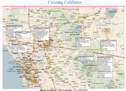
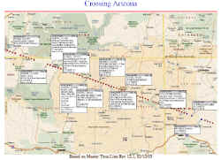
Houston, TX - The NASA website
dedicated to providing information about the ongoing Columbia Space Shuttle
investigation has provided a report showing the path of the shuttle as
it passed over the southwestern United States.The report, entitled "STS-107
Accident Investigation Ground Track and Events Summary Based on the Rev
12.1 Master Time Line," shows maps created with Microsoft's MapPoint software.
Shown below are thumbnail images of just two of the maps; one from the
flight over the San Francisco Bay Area; the second showing the path in
northeastern Arizona, not far from the "four corners" area.
 The report (in PDF format) showing its entire path, can be downloaded HERE.
The report (in PDF format) showing its entire path, can be downloaded HERE.
From Our Homepage
Saying Farewell to an Amazing Journey
Communicating with Maps
Is There a GIS Career Ladder?
What does it mean to be geospatially smart? Series
Ways Real Estate and Property Developers Utilize Melissa GeoData for Data-Driven Decisions
Unlocking Value From Daily Satellite Imagery and Insights
Maximizing the Value of Your Address Data with Geo Addressing
How Indoor Mapping Enhances the Security of Smart Buildings
Look Ahead: AI, Location Intelligence and Efficiency
Collaboration Takes on Sea Level Rise & Dynamic Technology Environments
Brownies for Brownfields
Has Everything Been Mapped Already?
How Is Data Literacy Changing in an Artificial Intelligence Landscape
Portfolios for GIS Professionals: More Than Just Maps
How to Create a Distance Matrix in QGIS - A Step-by-Step Guide
7 Ideas for Bringing GIS into the K-12 Classroom
The Geography of Movement