This article is a progress report describing what is
happening with nested geospatial networks and with sensor webs.
Nested Networks
Nested networks are networks built in a layered or hierarchical fashion using common network interfaces.For example, the USGS' The National Map is a nested network of geospatial resources that provides a national level view of several framework thematic layers of the United States.The National Map is made up of 50 independent state maps.There are 100 counties in North Carolina, about 40 of which have their own maps online and nested in the state map.Those county maps, by virtue of being part of the North Carolina map, are also part of The National Map.For each of those counties, there may be multiple map servers that each hold some of the constituent map layers, like transportation, land cover, land use, etc.In The National Map vision, eventually all the counties in all the United States will be part of The National Map.When that vision becomes a reality, a national land use map, for example, will be the combined product and responsibility of many local officials who have intimate knowledge of their own county's land use.
The layers in The National Map are accessed via OGC Web Services and the associated Web services infrastructure provided by other standards organizations such as the World Wide Web Consortium (W3C) and the Organization for the Advancement of Structured Information Standards (OASIS).All the servers implement the OpenGIS Web Map Server Implementation Specification, so a query submitted through software that implements that specification can be automatically passed down from one level to the next.
In the military, nesting would allow for a command or geointelligence net at the highest level of the command structure, then an overarching net for each branch of service.Inside the Army, there can be network layers for corps, divisions, brigades, battalions, etc.down to the lowest level, which might be a network connecting all the electronics inside one vehicle.A military network like this won't be on the Web. It will be a secured intranet, but it will use Web standards, and like The National Map, it will need OGC standards for discovery of and access to geospatial data and services.
Consider this example.NATO has released a Request for Tender to design and build an Enterprise Geographic Services Capability that relies on OpenGIS interfaces, as illustrated by this graphic taken from the procurement document.Such an architecture would provide an international layer above the U.S.military into which it, too, could nest, using these open interfaces.
Geospatial data at the different levels and from different servers won't have the same granularity, precision, attributes, etc., but automatic "rollups" will nevertheless be possible supporting queries to any level in the architecture.For example, each vehicle and each soldier in an army unit might eventually have a GPS, and for the first time in history, a commander at any level in the chain of command would know - because the coordinates and related attributes are encoded in a common way - where every soldier and vehicle is.
The network might run in sub-second real time in a tank or between tanks in a tank battalion, where hardware, software and data are optimized and tightly controlled.It won't run with such speed and predictability at higher levels where there is a lot of diversity in hardware, software and data.Access will be limited to meet security needs, but any geographic information or geographic processing service in the whole extended enterprise system can be made available, if the servers and clients all "speak OGC."
Sensor Webs
The many-layered geospatial network described above will soon have a new extension: sensor networks.Imagine thousands of sensors - including imaging devices on satellites, vehicles and humans as well as fixed meters and gages - all connected to the Web via wireless or wired technology, all reporting position and other information, all discoverable through metadata registered in catalogs, all readable remotely, and some controllable remotely.Engine temperature, respiration rate, water level, wind speed, radioactivity - virtually anything that can be gauged or imaged can be on a sensor web.Sensor webs provide a new means for finding, reading and controlling sensors on the Web, for acquiring dynamic data layers based on aggregated sensor inputs, and for automatically generating standards-based metadata that can be registered to make the data discoverable and usable.
Standards-based sensor networks will be based on IEEE 1451 specifications and also on OpenGIS Specifications that are emerging from a five year Sensor Web Enablement (SWE) effort in OGC.Included is a specification for a standard and straightforward way to characterize the location and "viewcone" of a video camera.Since April, the SWE specifications have gone through rigorous testing and improvement in the third OGC Web Services (OWS-3) testbed, which will conclude with a final demonstration of capabilities October 18-21, 2005 at SAIC in Tyson's Corner, VA.
After the demonstration, the SWE specifications will go to the next step in OGC's consensus process, and we anticipate that they will become approved OpenGIS Specifications, perhaps within this year.There is a growing sense of importance and urgency surrounding them, because they are slotted for roles in at least two Homeland Security initiatives, described below.
I hope the casual and infrequent observer of OGC will conclude from the material above that something significant has indeed been going on in OGC's corner of the geospatial industry.If you are a local official involved with geospatial information, you can anticipate that The National Map, GUARD and SensorNet will all become familiar to you in the next few years.These are manifestations of a maturing National Spatial Data Infrastructure.
Nested Networks
Nested networks are networks built in a layered or hierarchical fashion using common network interfaces.For example, the USGS' The National Map is a nested network of geospatial resources that provides a national level view of several framework thematic layers of the United States.The National Map is made up of 50 independent state maps.There are 100 counties in North Carolina, about 40 of which have their own maps online and nested in the state map.Those county maps, by virtue of being part of the North Carolina map, are also part of The National Map.For each of those counties, there may be multiple map servers that each hold some of the constituent map layers, like transportation, land cover, land use, etc.In The National Map vision, eventually all the counties in all the United States will be part of The National Map.When that vision becomes a reality, a national land use map, for example, will be the combined product and responsibility of many local officials who have intimate knowledge of their own county's land use.
The layers in The National Map are accessed via OGC Web Services and the associated Web services infrastructure provided by other standards organizations such as the World Wide Web Consortium (W3C) and the Organization for the Advancement of Structured Information Standards (OASIS).All the servers implement the OpenGIS Web Map Server Implementation Specification, so a query submitted through software that implements that specification can be automatically passed down from one level to the next.
In the military, nesting would allow for a command or geointelligence net at the highest level of the command structure, then an overarching net for each branch of service.Inside the Army, there can be network layers for corps, divisions, brigades, battalions, etc.down to the lowest level, which might be a network connecting all the electronics inside one vehicle.A military network like this won't be on the Web. It will be a secured intranet, but it will use Web standards, and like The National Map, it will need OGC standards for discovery of and access to geospatial data and services.
Consider this example.NATO has released a Request for Tender to design and build an Enterprise Geographic Services Capability that relies on OpenGIS interfaces, as illustrated by this graphic taken from the procurement document.Such an architecture would provide an international layer above the U.S.military into which it, too, could nest, using these open interfaces.
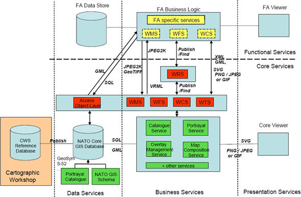 |
Geospatial data at the different levels and from different servers won't have the same granularity, precision, attributes, etc., but automatic "rollups" will nevertheless be possible supporting queries to any level in the architecture.For example, each vehicle and each soldier in an army unit might eventually have a GPS, and for the first time in history, a commander at any level in the chain of command would know - because the coordinates and related attributes are encoded in a common way - where every soldier and vehicle is.
The network might run in sub-second real time in a tank or between tanks in a tank battalion, where hardware, software and data are optimized and tightly controlled.It won't run with such speed and predictability at higher levels where there is a lot of diversity in hardware, software and data.Access will be limited to meet security needs, but any geographic information or geographic processing service in the whole extended enterprise system can be made available, if the servers and clients all "speak OGC."
Sensor Webs
The many-layered geospatial network described above will soon have a new extension: sensor networks.Imagine thousands of sensors - including imaging devices on satellites, vehicles and humans as well as fixed meters and gages - all connected to the Web via wireless or wired technology, all reporting position and other information, all discoverable through metadata registered in catalogs, all readable remotely, and some controllable remotely.Engine temperature, respiration rate, water level, wind speed, radioactivity - virtually anything that can be gauged or imaged can be on a sensor web.Sensor webs provide a new means for finding, reading and controlling sensors on the Web, for acquiring dynamic data layers based on aggregated sensor inputs, and for automatically generating standards-based metadata that can be registered to make the data discoverable and usable.
Standards-based sensor networks will be based on IEEE 1451 specifications and also on OpenGIS Specifications that are emerging from a five year Sensor Web Enablement (SWE) effort in OGC.Included is a specification for a standard and straightforward way to characterize the location and "viewcone" of a video camera.Since April, the SWE specifications have gone through rigorous testing and improvement in the third OGC Web Services (OWS-3) testbed, which will conclude with a final demonstration of capabilities October 18-21, 2005 at SAIC in Tyson's Corner, VA.
After the demonstration, the SWE specifications will go to the next step in OGC's consensus process, and we anticipate that they will become approved OpenGIS Specifications, perhaps within this year.There is a growing sense of importance and urgency surrounding them, because they are slotted for roles in at least two Homeland Security initiatives, described below.
- Oak Ridge National Laboratory, an OWS-3 sponsor, is working with OGC, the National Institute of Standards, the National Oceanographic and Atmospheric Administration, and the Department of Defense and others to develop an industry consensus standards platform - SensorNet - for a comprehensive, vendor-neutral nationwide system for real-time detection, identification and assessment of chemical, biological, radiological, nuclear and explosive hazards.
- GUARD, a program funded by one of the OWS-3 sponsors, is an initiative to develop an open platform and model that communities around the country can evaluate and adapt to serve local homeland security requirements for first responder communications and decision support.Applications like vehicle tracking, command and control, and video operate on top of GUARD's two-way wireless broadband capability for first responders.OGC Web Services, perhaps including SWE standards, will be among the capabilities they will demonstrate in the first GUARD demo in Q1 of 2006.
I hope the casual and infrequent observer of OGC will conclude from the material above that something significant has indeed been going on in OGC's corner of the geospatial industry.If you are a local official involved with geospatial information, you can anticipate that The National Map, GUARD and SensorNet will all become familiar to you in the next few years.These are manifestations of a maturing National Spatial Data Infrastructure.
From Our Homepage
Saying Farewell to an Amazing Journey
Communicating with Maps
Is There a GIS Career Ladder?
What does it mean to be geospatially smart? Series
Ways Real Estate and Property Developers Utilize Melissa GeoData for Data-Driven Decisions
Unlocking Value From Daily Satellite Imagery and Insights
Maximizing the Value of Your Address Data with Geo Addressing
How Indoor Mapping Enhances the Security of Smart Buildings
Look Ahead: AI, Location Intelligence and Efficiency
Collaboration Takes on Sea Level Rise & Dynamic Technology Environments
Brownies for Brownfields
Has Everything Been Mapped Already?
How Is Data Literacy Changing in an Artificial Intelligence Landscape
Portfolios for GIS Professionals: More Than Just Maps
How to Create a Distance Matrix in QGIS - A Step-by-Step Guide
7 Ideas for Bringing GIS into the K-12 Classroom
The Geography of Movement