Navigation Components
What's new in components? How about this: a navigation component. What's that? It's the technology that provides turn-by-turn directions and the data to base it on, and a voice to speak them, in one component.That's SimaTech's Navi Engine, built on .NET with data from Tele Atlas, and support for English, German and Danish voice prompts.Since the company can pull from any of Tele Atlas' data sets, components are custom built, when needed, with specific geographies.Many countries are available "off the shelf." The product is geared to those who want to build navigation products or integrate navigation into existing GIS products.
Snowplow Tracking
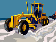 With so
many booths in the showcase area, it can be tough to grab people's
attention.I saw "Snowplow Tracking" and was intrigued.Enterprise Information Systems
offers a focused app just for that task.Originally commissioned by a
county, the app evolved into a product, which among other things,
tracks the plows and provides online status reports of what's been
plowed.Other offerings capture data from cameras for asset management.
That, I was told, is becoming more common in cities and counties with
GASB34 and homeland security needs.Moreover, once data is collected
and "brought home," it can be used to inventory signs for one user and
sidewalks for another.Like many of the offerings in today's market,
the company will sell you the system, collect the data or even deliver
the complete database depended on the needs and budget.
With so
many booths in the showcase area, it can be tough to grab people's
attention.I saw "Snowplow Tracking" and was intrigued.Enterprise Information Systems
offers a focused app just for that task.Originally commissioned by a
county, the app evolved into a product, which among other things,
tracks the plows and provides online status reports of what's been
plowed.Other offerings capture data from cameras for asset management.
That, I was told, is becoming more common in cities and counties with
GASB34 and homeland security needs.Moreover, once data is collected
and "brought home," it can be used to inventory signs for one user and
sidewalks for another.Like many of the offerings in today's market,
the company will sell you the system, collect the data or even deliver
the complete database depended on the needs and budget.
Into the Field
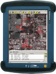 Marshall GIS was
showing off its mobile solution, GeoResults Mobile, or what it calls
tools to "extend your enterprise to the field." The mobile client,
built on ArcEngine, runs on a ruggedized tablet and has a very simple
interface.Noted the rep, "most folks don't know GIS and some are not
familiar with computers." One of the most popular tools in the
interface? "Locate me" which works with an optional GPS.The big
excitement at Marshall was how easy it was to port their ArcEngine
based solution to ArcGIS Server.Now, it's really up the client which
solution makes sense.In the field, or in natural disasters, an
ArcEngine based client is likely better since a stable connection may
not be available.In more "civilized" areas, a server app may be best.
The product has developed a following for utilities and related
industries, but there's work on a solution for appraisers, too.
Marshall GIS was
showing off its mobile solution, GeoResults Mobile, or what it calls
tools to "extend your enterprise to the field." The mobile client,
built on ArcEngine, runs on a ruggedized tablet and has a very simple
interface.Noted the rep, "most folks don't know GIS and some are not
familiar with computers." One of the most popular tools in the
interface? "Locate me" which works with an optional GPS.The big
excitement at Marshall was how easy it was to port their ArcEngine
based solution to ArcGIS Server.Now, it's really up the client which
solution makes sense.In the field, or in natural disasters, an
ArcEngine based client is likely better since a stable connection may
not be available.In more "civilized" areas, a server app may be best.
The product has developed a following for utilities and related
industries, but there's work on a solution for appraisers, too.
LiDAR Feature Extraction
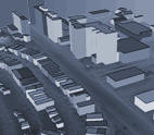 Visual Learning
Systems, the folks behind Feature Analyst, were showing off their
tools (actually a "plug-in toolkit") to extract buildings from LiDAR
data.There's no "teaching the system" when it comes to this toolset.
The user needs simply to set some parameters, such as how steep a roof
to look for, or what type of texture to explore.Then, with the push of
a button, 3D buildings are created.For now, they are simple 3D
features, but in a future release, they will be complex data types.
Those in homeland security and urban warfare are the target audience,
though there are many civilian applications, too (think MSN Virtual
Earth, etc.).More and more counties, the representative said, have
LiDAR data and want to use it.
Visual Learning
Systems, the folks behind Feature Analyst, were showing off their
tools (actually a "plug-in toolkit") to extract buildings from LiDAR
data.There's no "teaching the system" when it comes to this toolset.
The user needs simply to set some parameters, such as how steep a roof
to look for, or what type of texture to explore.Then, with the push of
a button, 3D buildings are created.For now, they are simple 3D
features, but in a future release, they will be complex data types.
Those in homeland security and urban warfare are the target audience,
though there are many civilian applications, too (think MSN Virtual
Earth, etc.).More and more counties, the representative said, have
LiDAR data and want to use it.
Please Touch the Terrain
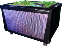 After
seeing the mountains "rise up" on the Northrop Grumman/Applied Minds terrain table on
stage, I had to see it up close.I was really intrigued when the
presenter from Applied Minds said we could touch it! GIS geeks were
like kids (as were the kids who checked it out on family night).The
table uses ball-tipped pistons to stretch a rubberized surface into the
right shape.The ball tips were about the size of super balls and I
wondered if that meant a less accurate (potentially) product.In fact,
the image that's projected on the table provides the rest of the data
and human brain interpolates it at quite high resolution.The big
question at the table? How much? The answer: it's a prototype so it has
no value...yet.Even after seeing the rubber cover "rise up" several
times, I still felt like I was watching a sci fi movie special effect!
After
seeing the mountains "rise up" on the Northrop Grumman/Applied Minds terrain table on
stage, I had to see it up close.I was really intrigued when the
presenter from Applied Minds said we could touch it! GIS geeks were
like kids (as were the kids who checked it out on family night).The
table uses ball-tipped pistons to stretch a rubberized surface into the
right shape.The ball tips were about the size of super balls and I
wondered if that meant a less accurate (potentially) product.In fact,
the image that's projected on the table provides the rest of the data
and human brain interpolates it at quite high resolution.The big
question at the table? How much? The answer: it's a prototype so it has
no value...yet.Even after seeing the rubber cover "rise up" several
times, I still felt like I was watching a sci fi movie special effect!
What's new in components? How about this: a navigation component. What's that? It's the technology that provides turn-by-turn directions and the data to base it on, and a voice to speak them, in one component.That's SimaTech's Navi Engine, built on .NET with data from Tele Atlas, and support for English, German and Danish voice prompts.Since the company can pull from any of Tele Atlas' data sets, components are custom built, when needed, with specific geographies.Many countries are available "off the shelf." The product is geared to those who want to build navigation products or integrate navigation into existing GIS products.
Snowplow Tracking
With so
many booths in the showcase area, it can be tough to grab people's
attention.I saw "Snowplow Tracking" and was intrigued.Enterprise Information Systems
offers a focused app just for that task.Originally commissioned by a
county, the app evolved into a product, which among other things,
tracks the plows and provides online status reports of what's been
plowed.Other offerings capture data from cameras for asset management.
That, I was told, is becoming more common in cities and counties with
GASB34 and homeland security needs.Moreover, once data is collected
and "brought home," it can be used to inventory signs for one user and
sidewalks for another.Like many of the offerings in today's market,
the company will sell you the system, collect the data or even deliver
the complete database depended on the needs and budget.Into the Field
Marshall GIS was
showing off its mobile solution, GeoResults Mobile, or what it calls
tools to "extend your enterprise to the field." The mobile client,
built on ArcEngine, runs on a ruggedized tablet and has a very simple
interface.Noted the rep, "most folks don't know GIS and some are not
familiar with computers." One of the most popular tools in the
interface? "Locate me" which works with an optional GPS.The big
excitement at Marshall was how easy it was to port their ArcEngine
based solution to ArcGIS Server.Now, it's really up the client which
solution makes sense.In the field, or in natural disasters, an
ArcEngine based client is likely better since a stable connection may
not be available.In more "civilized" areas, a server app may be best.
The product has developed a following for utilities and related
industries, but there's work on a solution for appraisers, too.LiDAR Feature Extraction
Visual Learning
Systems, the folks behind Feature Analyst, were showing off their
tools (actually a "plug-in toolkit") to extract buildings from LiDAR
data.There's no "teaching the system" when it comes to this toolset.
The user needs simply to set some parameters, such as how steep a roof
to look for, or what type of texture to explore.Then, with the push of
a button, 3D buildings are created.For now, they are simple 3D
features, but in a future release, they will be complex data types.
Those in homeland security and urban warfare are the target audience,
though there are many civilian applications, too (think MSN Virtual
Earth, etc.).More and more counties, the representative said, have
LiDAR data and want to use it.Please Touch the Terrain
After
seeing the mountains "rise up" on the Northrop Grumman/Applied Minds terrain table on
stage, I had to see it up close.I was really intrigued when the
presenter from Applied Minds said we could touch it! GIS geeks were
like kids (as were the kids who checked it out on family night).The
table uses ball-tipped pistons to stretch a rubberized surface into the
right shape.The ball tips were about the size of super balls and I
wondered if that meant a less accurate (potentially) product.In fact,
the image that's projected on the table provides the rest of the data
and human brain interpolates it at quite high resolution.The big
question at the table? How much? The answer: it's a prototype so it has
no value...yet.Even after seeing the rubber cover "rise up" several
times, I still felt like I was watching a sci fi movie special effect!From Our Homepage
Saying Farewell to an Amazing Journey
Communicating with Maps
Is There a GIS Career Ladder?
What does it mean to be geospatially smart? Series
Ways Real Estate and Property Developers Utilize Melissa GeoData for Data-Driven Decisions
Unlocking Value From Daily Satellite Imagery and Insights
Maximizing the Value of Your Address Data with Geo Addressing
How Indoor Mapping Enhances the Security of Smart Buildings
Look Ahead: AI, Location Intelligence and Efficiency
Collaboration Takes on Sea Level Rise & Dynamic Technology Environments
Brownies for Brownfields
Has Everything Been Mapped Already?
How Is Data Literacy Changing in an Artificial Intelligence Landscape
Portfolios for GIS Professionals: More Than Just Maps
How to Create a Distance Matrix in QGIS - A Step-by-Step Guide
7 Ideas for Bringing GIS into the K-12 Classroom
The Geography of Movement