Click on either image
for larger view
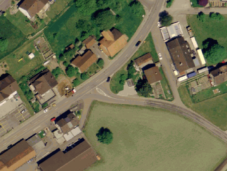
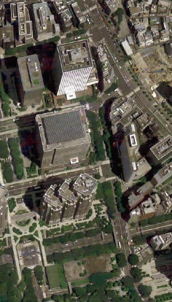
Ortho-photos such as these are becoming a more commonly requested deliverable for photogrammetric products.Thanks to the new digital sensors on the market and more automated software, ortho-photos can now be processed faster and more easily than ever before.The images of Waldkirch, Switzerland (left) and Tokyo, Japan (right) were acquired with the Leica ADS40 sensor.(Images courtesy of Leica Geosystems GIS & Mapping, LLC.)
Automation
The industry has recently
made huge strides in improving the automation of the ortho-photo production
workflow.In the past, ortho-photo production was a very slow, difficult
and expensive procedure.The workflow required numerous, tedious and time-consuming
manual steps.Now, ortho-photo creation has become a much more automated
process, resulting in higher production and lower cost.With current computer
systems built to handle larger amounts of data, photogrammetric software
workflows have additional, automated procedures that can handle the growth
demanded by the market.Today's photogrammetric software, such as Leica
Geosystems' Leica Photogrammetry Suite (LPS), includes more automated feature
recognition, batch processing capabilities and fewer manual interventions.
The combination of such improvements is driving down the price of final
products while fueling the quality demand of end products.This means organizations
are now more likely to invest in more computer systems to process imagery
than they were in the past.
Speed of Production
One of the biggest problems
of the past was that map delivery took so long that the maps were often
outdated before they were delivered.The market desperately needed to reduce
delivery time in order to have timely, useful data.By shortening the map
replacement cycle, the value of the maps has been greatly enhanced.In
addition to better data processing software and computers, the new digital
cameras have made significant gains towards achieving this goal.
Ortho-photo production essentially includes the same steps whether done digitally or with film.What digital imagery has achieved that film-based systems could not, is added production speed. The throughput, or time between data capture and final ortho-photo delivery, has been drastically shortened in the last few years.The new digital camera systems entering the market eliminate the need to process and scan film, an important step in the ability to deliver a larger amount of higher-quality data, with a faster turnaround time.Products such as the Leica ADS40, a market-leading airborne digital sensor, can cover large areas of interest, rectify imagery and transfer smoothly into the post-processing phase with its proprietary Leica GPro software or third-party software.
Demand
The emergence of new software
and hardware, higher production rate of products and widespread demands
for imagery are primarily responsible for the increased desire for ortho-photos.
This demand is driven by numerous sources.For one, the availability of
high-quality aerial photography sources has grown substantially.Additionally,
companies that provide photogrammetric services are using more film and
digital cameras than in the past.The greatest advance in imagery, however,
has come from commercial satellite image providers like Space Imaging and
DigitalGlobe.As planners, engineers, politicians, land managers and other
decision makers learn how to use photographic data, they are becoming more
dependent on this source of information.This drives the increase in demand
for imagery and, more importantly, the demand for imagery that contains
more detail and accuracy.Satellite image providers alone have not been
able to keep up with these demands, leaving a growing opportunity for airborne
digital sensors.
The Future of Workflows
The industry is growing
at a steady pace.Hardware and software providers are steadily developing
faster and more automated products that still maintain high-quality outputs.
Solutions providers such as Leica Geosystems are answering the market's
demand by offering products that power the entire Geospatial Imaging Chain
of capturing, referencing, measuring, analyzing and presenting geospatial
information.Such providers are proving to end-users that ortho-photo-derived
maps equal better value on money spent.These maps empower end-users to
address their markets quickly and with better results.
Because of the advances made in the quality and turnaround time of ortho-photos, users are putting better information in the hands of decision makers.This helps planners, engineers and others make more informed and accurate decisions in their work.For example, a transportation department planning a new roadway can obtain a map of the proposed area that is more detailed and accurate than a map used several years before.Using the improved information available within the map, they can make more informed decisions that will positively impact the town's overall driving conditions.
Overall, the market trend
is that of an upward spiral: more products (in this case ortho-photos)
received, plus improved quality, speed and accuracy equal more up-to-date
information.Organizations that have the same product budget they did a
few years ago are now able to buy more with that same amount of money,
resulting in more, better-quality map products than ever before.The added
value provides all parties involved with more opportunities to grow their
businesses, make better decisions and improve the accuracy, simultaneously
reducing their costs.The advent of image-based deliverables becoming a
part of photogrammetry projects is yet another step towards faster, more
spatially accurate results for the geospatial community.