Protecting the environment is no longer a matter of
civic conscience or discretion. Increasingly, municipalities are being
held to strict federal standards for wastewater collection, wastewater
treatment and related activities. This past fall, Utility Sealing
Systems, Inc. (USSI)
of Venice, Florida, a company that helps utilities across America
protect their wastewater collection systems from rainwater inflow,
found a way to deliver better service faster.
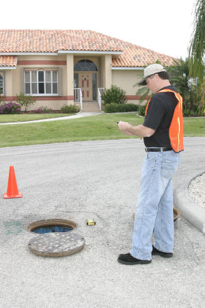
USSI's expertise lies in a patented technology that seals leaks in the collection systems. The most common entry points for rainwater are in the manhole structures and the lateral lines. This inflow causes backups and overflows, as well as adding to the costs of wastewater treatment. These costs can be significant because utilities must treat all water that enters the system and goes to the wastewater treatment plants. If the flow doubles during a rain event, as is often the case, the cost and the impact on plant operations is substantial. Overflows can also run up costs due to environmental violations and structural damage, and the subsequent fines and repair costs.
USSI offers a solution via its "G7 Program." The
challenge has been
speed of assessment/delivery and accurate reporting for complex, large
scale and inadequately mapped systems.
When USSI tackled a project for Palm Beach County, Florida using FAST software from GeoAge, the company's challenges also became increased opportunities. (FAST stands for Field Adapted Survey Toolkit, and is a tool that makes collecting data in the field easy.) Palm Beach County had just acquired a new system and needed to have it brought up to county standards. The utility also needed reliable coordinates and maps for the system. Operating from field-friendly Palm Treo mobile PDAs, FAST enabled custom data survey creation, links to GPS mapping and the Internet, and instant reports via wireless communications to project headquarters. In Palm Beach County, the boost to operational accuracy and speed surpassed expectations.
"Before FAST, we used a paper-based system to create the reports on each project. When information was entered in the field, then reentered at project headquarters, the duplication increased the likelihood for error. Reassessments were often required, adding lots of time delays and unnecessary labor costs," noted Lloyd Wander, USSI's president.
FAST facilitates savings
With FAST in place, the USSI team sped through its process, approaching the difficult task of surveying each component of the utility's wastewater collection system with new confidence. In rapid sequence, technicians located and sealed manhole chimneys, completed data capture forms, attached precise GPS locations and digital photos, and provided reports. Afterwards, USSI stated that enhanced reporting had turned out to be one of the biggest benefits of FAST.
"It's a great advantage for our customers and for USSI," said Wander. "We believed that technology could offer a more efficient and higher quality process. And that's just what FAST has done."
With a new way to capture and integrate data, enhance data accuracy and boost reporting functions, USSI technicians could focus on their core competency: helping utilities protect critical water resources by providing economical solutions to rainwater inflow. "In Palm Beach County, we saw that the effort on our part was dramatically different," said Wander. "A report that previously took two days to assemble can now be done in four hours. That's because when the data comes to us, it's all in one file, compiled and ready to print. FAST has given us a real leg up in our industry."
The impact was even more remarkable considering turnaround. USSI's impressive results in Palm Beach County were accomplished just a month after the first contact with GeoAge - and after only one day of team training on the software.
"FAST is an easy-deploy option for field teams with varying degrees of technical skill," said GeoAge president Jeff Arnold. "Basically, anyone who is comfortable using a Windows-based program can pick up FAST quickly. At the same time, it's an extremely robust program that offers unprecedented flexibility.
Faster, more reliable data
The implications for teams like USSI are enormous. With eco-friendly wastewater treatment federally mandated across the country, utilities are scrambling to comply. The challenge of mapping and assessing potential inflow points is staggering in scope, its difficulty magnified by outdated reporting methods. In Palm Beach County, FAST helped workers organize operations "on the fly." Working from data survey forms created for the event, they were instantly "on the same page" with project objectives. Internet and GIS/GPS access from the field helped to improve accuracy and facilitate repair work. With team workers linked from their hand-held Palm Treos, reporting was not only faster, but also more usable than ever before.
Wander believes that improved mapping and reporting will have a positive long-term impact. "Now, Palm Beach County has the data on their newly acquired wastewater system that they can depend on for accuracy," he noted. "The County can reference our GPS coordinates and put them right into a GIS system. This simplifies their life and gives them the information they need."
A program with multiple applications
"We're delighted with the impact of FAST this first time out of the gate with USSI," Arnold said. "It provides another great example - and there are many - of the adaptability of the software to a wide range of enterprises. FAST is the first data collection software that integrates mapping as part of a field report. It is fully compatible with current geospatial technology, including Web-based GIS. You can opt for GPS or GPS Altitude for 3-D imaging, or geocoding using Google Earth."
USSI's expertise lies in a patented technology that seals leaks in the collection systems. The most common entry points for rainwater are in the manhole structures and the lateral lines. This inflow causes backups and overflows, as well as adding to the costs of wastewater treatment. These costs can be significant because utilities must treat all water that enters the system and goes to the wastewater treatment plants. If the flow doubles during a rain event, as is often the case, the cost and the impact on plant operations is substantial. Overflows can also run up costs due to environmental violations and structural damage, and the subsequent fines and repair costs.
 |
When USSI tackled a project for Palm Beach County, Florida using FAST software from GeoAge, the company's challenges also became increased opportunities. (FAST stands for Field Adapted Survey Toolkit, and is a tool that makes collecting data in the field easy.) Palm Beach County had just acquired a new system and needed to have it brought up to county standards. The utility also needed reliable coordinates and maps for the system. Operating from field-friendly Palm Treo mobile PDAs, FAST enabled custom data survey creation, links to GPS mapping and the Internet, and instant reports via wireless communications to project headquarters. In Palm Beach County, the boost to operational accuracy and speed surpassed expectations.
"Before FAST, we used a paper-based system to create the reports on each project. When information was entered in the field, then reentered at project headquarters, the duplication increased the likelihood for error. Reassessments were often required, adding lots of time delays and unnecessary labor costs," noted Lloyd Wander, USSI's president.
FAST facilitates savings
With FAST in place, the USSI team sped through its process, approaching the difficult task of surveying each component of the utility's wastewater collection system with new confidence. In rapid sequence, technicians located and sealed manhole chimneys, completed data capture forms, attached precise GPS locations and digital photos, and provided reports. Afterwards, USSI stated that enhanced reporting had turned out to be one of the biggest benefits of FAST.
"It's a great advantage for our customers and for USSI," said Wander. "We believed that technology could offer a more efficient and higher quality process. And that's just what FAST has done."
With a new way to capture and integrate data, enhance data accuracy and boost reporting functions, USSI technicians could focus on their core competency: helping utilities protect critical water resources by providing economical solutions to rainwater inflow. "In Palm Beach County, we saw that the effort on our part was dramatically different," said Wander. "A report that previously took two days to assemble can now be done in four hours. That's because when the data comes to us, it's all in one file, compiled and ready to print. FAST has given us a real leg up in our industry."
The impact was even more remarkable considering turnaround. USSI's impressive results in Palm Beach County were accomplished just a month after the first contact with GeoAge - and after only one day of team training on the software.
"FAST is an easy-deploy option for field teams with varying degrees of technical skill," said GeoAge president Jeff Arnold. "Basically, anyone who is comfortable using a Windows-based program can pick up FAST quickly. At the same time, it's an extremely robust program that offers unprecedented flexibility.
Faster, more reliable data
The implications for teams like USSI are enormous. With eco-friendly wastewater treatment federally mandated across the country, utilities are scrambling to comply. The challenge of mapping and assessing potential inflow points is staggering in scope, its difficulty magnified by outdated reporting methods. In Palm Beach County, FAST helped workers organize operations "on the fly." Working from data survey forms created for the event, they were instantly "on the same page" with project objectives. Internet and GIS/GPS access from the field helped to improve accuracy and facilitate repair work. With team workers linked from their hand-held Palm Treos, reporting was not only faster, but also more usable than ever before.
 |
Wander believes that improved mapping and reporting will have a positive long-term impact. "Now, Palm Beach County has the data on their newly acquired wastewater system that they can depend on for accuracy," he noted. "The County can reference our GPS coordinates and put them right into a GIS system. This simplifies their life and gives them the information they need."
A program with multiple applications
"We're delighted with the impact of FAST this first time out of the gate with USSI," Arnold said. "It provides another great example - and there are many - of the adaptability of the software to a wide range of enterprises. FAST is the first data collection software that integrates mapping as part of a field report. It is fully compatible with current geospatial technology, including Web-based GIS. You can opt for GPS or GPS Altitude for 3-D imaging, or geocoding using Google Earth."
From Our Homepage
Saying Farewell to an Amazing Journey
Communicating with Maps
Is There a GIS Career Ladder?
What does it mean to be geospatially smart? Series
Ways Real Estate and Property Developers Utilize Melissa GeoData for Data-Driven Decisions
Unlocking Value From Daily Satellite Imagery and Insights
Maximizing the Value of Your Address Data with Geo Addressing
How Indoor Mapping Enhances the Security of Smart Buildings
Look Ahead: AI, Location Intelligence and Efficiency
Collaboration Takes on Sea Level Rise & Dynamic Technology Environments
Brownies for Brownfields
Has Everything Been Mapped Already?
How Is Data Literacy Changing in an Artificial Intelligence Landscape
Portfolios for GIS Professionals: More Than Just Maps
How to Create a Distance Matrix in QGIS - A Step-by-Step Guide
7 Ideas for Bringing GIS into the K-12 Classroom
The Geography of Movement