Ed note: This is part two of a three-part article on this subject. The first part
appeared on June 14. Part two in the series addresses the process of
evaluating how BIM could be implemented at the center, and examines
whether many BIM functions are perhaps already in place via the
existing GIS.
Why is MSFC Researching BIM?
The Marshall Space Flight Center (MSFC) is a very large complex located on the Redstone Army Arsenal (over 40,000 acres) in Huntsville, Alabama. According to the 2010 Real Property Book, Marshall has 273 facilities onsite, totaling around 4.8 million square feet of property. These facilities include workshops, office buildings, trailers, laboratories, test stands and other structures that are spread across 1,873 acres under an irrevocable 99 year usage loan from the Department of the Army. The total capitalized value of these structures equals $485,142,235 while the current replacement value of these is $1,599,425,383. One interesting fact about Marshall is that it was the very first NASA field center, meaning that many of the buildings on location have been used since the center was formed in 1960. Currently, there are 185 buildings, facilities and structures that have been in use for over 20 years.
With all this in mind, NASA is researching BIM to see if its capabilities would be beneficial. With the time and money needed to implement BIM, the question MSFC is asking is would it be worth the investment costs to utilize BIM technologies on existing buildings as well as new projects? Or is it more cost-effective to apply it to new designs as they come along? In the next five years, between three and five new buildings, at most, will be constructed. The main issue MSFC is debating is not BIM's value as a great new technology, but rather is the return on investment significant enough?
Beyond researching the opportunities that BIM can provide, NASA headquarters has issued a draft directive to the field centers which requires BIM to be implemented into their existing process. This can be seen in the FY 2012 Capital Facilities Investment Program Data Call (Appendix III, pdf ). An excerpt from the document reads: "All FY 2012 Discrete Facility Projects will be required to utilize Building Information Modeling (BIM) during the design and construction; therefore, please plan accordingly for any software or other costs that you may need to support the project." From this, a guideline titled "Building Information Modeling (BIM) Guidelines and Standards for Architects, Engineers, and Contractors" was created (Appendix IV, pdf ). The first draft of this standard was sent to all NASA centers' Facilities Offices for review and modification. Basically, the guideline requires that BIM methods be used on any new project after October 1, 2010 with funding of $10 million or more. NASA's goal, as stated in the document, is to have all projects using BIM by at least 2012. Once these documents were handed down to MSFC from headquarters, a team assembled to research all aspects of BIM to see if full utilization would be worth the investment.
As the building industry grows, technologies are becoming more advanced in an attempt to make these processes more smooth and effortless. In today's economy, companies are required to make adjustments to new and evolving technologies. MSFC's design and construction processes are considered by many to be BIM, but not to the full extent. The processes used and information that is obtained throughout the design and construction follow hand-in-hand with BIM's definitions and standards. As for the modeling, MSFC does not use the common 3D software (Bentley Architecture, Revit, etc.) that most companies use to do BIM. The processes at MSFC have been described as being 85% BIM, meaning MSFC is not quite using all of BIM's capabilities, but it is doing enough to be called a BIM user. All of the uses of BIM are being studied in an effort to one day implement its full capabilities into the existing building design and construction processes.
National Building Information Modeling Standard
BIM is no doubt on the rise. It has the potential to be the standard in project planning, design and construction. It will not be long before every piece of available information about a project will be accessible electronically. Since BIM is a new form of technology, no infrastructure or standards have been formed. Because of this, the buildingSMARTalliance was created by a committee of engineers, designers and contractors looking to have input on the design and construction industries. The purpose of the alliance is to create interoperability for firms utilizing building information models, as well as to assist in the optimization of cost, sustainability and the environmental aspects of project design and construction.
Within the alliance is the National Building Information Modeling
Standard Project Committee, or NBIMS. Formed in 2005, the sole purpose
of the NBIMS committee is to create a standard and infrastructure to
foster and promote the advancements and innovations that are growing
with the industry. After standardizing the information for a facility,
not only does it organize the life-cycle information, but it also
provides a basis for prolonged existence of the information belonging
to the project. The committee is hopeful that the standard will be used
universally and will mature over time. As part of its BIM research,
MSFC is using the standard as framework for the implementation of
MSFC's BIM process.
One item from the NBIMS, the Capability Maturity Model, has been a great help. This model is a way to measure the extent to which a particular company or organization is utilizing BIM. It gives users a way to understand just how complete their design method is, and if it could, in fact, be called BIM. The model uses a point system to grade an existing process based on 11 different elements that represent a BIM process. There are Data Richness, Life-Cycle Views, Change Management, Roles or Disciplines, Business Process, Timeliness/Response, Delivery Method, Graphical Information, Spatial Capacity, Information Accuracy, and Interoperability/IFC Support. The definitions of these can be found in the category descriptions section of the model (Appendix V, pdf ).
The Maturity Model is very straightforward. You simply analyze each element of your existing processes and compare each to the element definitions to determine a score on a scale from 1 to 10. After you have graded each area, the model yields a credit sum for your method and relates it to the standard credit arranged by NBIMS. You are then given a Maturity Level according to your credit, which determines whether or not your process can be considered BIM. The different maturity levels, shown here from lowest to highest, consist of Not Certified, Minimum BIM, Certified, Silver, Gold and Platinum. The Marshall team has analyzed its project design and construction process and placed its findings into the model (Appendix V, pdf ) finding that its methods score a 77. This is considered a "Silver" rating.
Marshall Space Flight Center's Existing Design Process
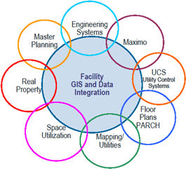
To begin research into BIM, MSFC had to first look at its own processes used in the facilities office. Before BIM software became available, Marshall formed what it called Facilities Geographical Information System, or FacGIS in 2002. By definition, a Geographical Information System (GIS) captures, stores, manages, analyzes and presents geographic data that are linked to different databases. NASA's FacGIS integrates several aspects of Marshall's entire property.
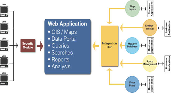
Through the years, the Facilities Management Office at MSFC has created and maintained several different databases, facility maps and CAD drawings for the different tasks that are required of the department. The problem with all of these records is that they do not work together. They require specific personnel with the correct training in order to be utilized. Prior to the FacGIS system, engineers, designers, contractors and decision makers had to interface with each individual who dealt with the needed system. For instance, in order to get drawings of utilities or aerial photographs, you would have to visit the Mapping Department, and then you would have to contact the Environmental Office to obtain specific information pertaining to any ecological data. Following that, you then had to turn to Asset Management for work orders and equipment reports, then the Planning Department, Space Management, and so on. With the FacGIS, the needed maps, plans, reports, and any other datasets could be accessed from a single computer.
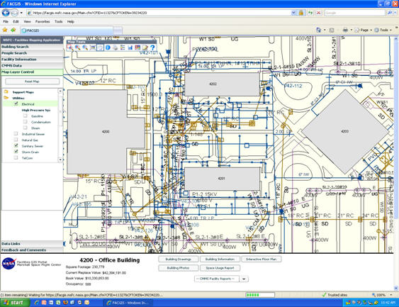
The FacGIS is very versatile. Obviously, the objectives of the software are to provide access to all segments of the facilities data. The databases remain in place, while the FacGIS system pulls the data in and makes them available to the user. The software has the ability to retrieve information such as map layers, floor plans, roof and space management, utilities, spread sheets, redlining, utility control systems (UCS), environmental and even location services. For example, you can find any building, along with any person who works in the building and what room they occupy. Not only that, you can find what equipment is located there, such as computers or printers, view any work orders placed for that room, and even examine the utilities that run through the floor and ceiling. The versatility of this program allows engineers and project planners to generate any reports, plans or maps, and everyone related to the project has the ability to view any of the data and analyze them from their perspective.
MSFC currently uses Bentley MicroStation products for its Computer Assisted Drafting. More specifically, MicroStation V8 is the software of choice, and V8i will be implemented in the coming months. This technology allows engineers, designers and contractors the ability to design, model, visualize, document, map and sustain infrastructure projects. The software has the capability to model in 3D, but it is not BIM accredited software. Though this software may not be viewed as "BIM," it is used by the Facilities Office in the exact same manner as a BIM accredited model. Any relevant data that are collected will be placed in the model and remain there for utilization throughout the life of the project.
How Does MSFC's Process Compare to NBIMS?
On the surface, MSFC's design and construction process, along with the FacGIS, may not look like a BIM process, but as you look deeper you will see that it is just as advanced and beneficial as any BIM method. Since the FacGIS development in 2002, the Facilities Office has made continual progress on design and construction documentation methodologies to fit today's BIM technology. As stated earlier, BIM is a technologically advanced process, something that the Facilities Department feels it has. MSFC has used the NBIMS to educate itself on the philosophies surrounding BIM. With the standard as a guideline, MSFC has been able to evaluate the existing processes and relate them to those in the standard. Like the NBIMS, MSFC follows the most important section very closely: Information Exchange. Information is the leading area in a design process. A firm must be very solid in this element in order to be considered a BIM process, and this is the strong point in MSFC's system. Any new information and data are entered into the FacGIS system. This information can be utilized by almost everyone who has a part in the project, such as the designers, contractors, those in construction, operations and maintenance. This is where MSFC gets most of its credit in the Maturity Model. Since BIM is said to be all about the information, it is also seen by many to be centered around the model, though this isn't always the case. Many companies are very reliant on their models, in that every bit of information and data are retrieved from the model. The model is created before the construction takes place, and its interactive abilities allow users to simply "click" within the model to get the needed data. This is where MSFC's process differs from most BIM processes. A 3D model is not the nucleus of the MSFC system. In fact, the FacGIS is where users go to get their information. Even though it is not a 3D model, it still has the same benefits. Since its databases are continually used and updated daily, the intelligence of the FacGIS is always up-to-date. What separates MSFC from other NASA centers is that the information in the model is not only continually growing, but it is always available for reference and use. Most companies retire their model once the project is complete because they do not have the ability to maintain the model. This may be due to the fact that they do not have the required training or personnel to deal with the model, which inevitably leads to its retirement. MSFC, on the other hand, is a leader among other NASA centers in keeping its models in use, always maintaining them, and adding data while always keeping them available for those who may need to use them.
With regard to the requirement handed down from headquarters, MSFC does not need full BIM capabilities to keep productivity high. With close to 300 buildings onsite, Marshall's Facilities Engineering group deals primarily with modifications to existing buildings. The only way that full BIM technologies would be utilized would be if the existing buildings were to be modeled. This would take a large amount of time and money. Also, since a majority of these buildings are 40+ years old, many of the utilities and electrical components have minimal documentation, if any at all. Three-dimensional laser scanning technology is the only possible way to have a correct model. This type of process takes a highly skilled team and a great deal of time and money. As for new buildings that will be constructed in the coming years, total BIM methodologies would be a great addition. This would increase the productivity quite a bit, and make the entire project more effortless. The expense and effort required to fully implement BIM are significant. This would not be a smart investment if it were only to be used on new building design and construction, which makes up less than 5% of the facilities MSFC maintains.
Ed. Note: Part three of this article will be published next Monday, and will address the process of evaluating how BIM could be implemented at the center.
Why is MSFC Researching BIM?
The Marshall Space Flight Center (MSFC) is a very large complex located on the Redstone Army Arsenal (over 40,000 acres) in Huntsville, Alabama. According to the 2010 Real Property Book, Marshall has 273 facilities onsite, totaling around 4.8 million square feet of property. These facilities include workshops, office buildings, trailers, laboratories, test stands and other structures that are spread across 1,873 acres under an irrevocable 99 year usage loan from the Department of the Army. The total capitalized value of these structures equals $485,142,235 while the current replacement value of these is $1,599,425,383. One interesting fact about Marshall is that it was the very first NASA field center, meaning that many of the buildings on location have been used since the center was formed in 1960. Currently, there are 185 buildings, facilities and structures that have been in use for over 20 years.
With all this in mind, NASA is researching BIM to see if its capabilities would be beneficial. With the time and money needed to implement BIM, the question MSFC is asking is would it be worth the investment costs to utilize BIM technologies on existing buildings as well as new projects? Or is it more cost-effective to apply it to new designs as they come along? In the next five years, between three and five new buildings, at most, will be constructed. The main issue MSFC is debating is not BIM's value as a great new technology, but rather is the return on investment significant enough?
Beyond researching the opportunities that BIM can provide, NASA headquarters has issued a draft directive to the field centers which requires BIM to be implemented into their existing process. This can be seen in the FY 2012 Capital Facilities Investment Program Data Call (Appendix III, pdf ). An excerpt from the document reads: "All FY 2012 Discrete Facility Projects will be required to utilize Building Information Modeling (BIM) during the design and construction; therefore, please plan accordingly for any software or other costs that you may need to support the project." From this, a guideline titled "Building Information Modeling (BIM) Guidelines and Standards for Architects, Engineers, and Contractors" was created (Appendix IV, pdf ). The first draft of this standard was sent to all NASA centers' Facilities Offices for review and modification. Basically, the guideline requires that BIM methods be used on any new project after October 1, 2010 with funding of $10 million or more. NASA's goal, as stated in the document, is to have all projects using BIM by at least 2012. Once these documents were handed down to MSFC from headquarters, a team assembled to research all aspects of BIM to see if full utilization would be worth the investment.
As the building industry grows, technologies are becoming more advanced in an attempt to make these processes more smooth and effortless. In today's economy, companies are required to make adjustments to new and evolving technologies. MSFC's design and construction processes are considered by many to be BIM, but not to the full extent. The processes used and information that is obtained throughout the design and construction follow hand-in-hand with BIM's definitions and standards. As for the modeling, MSFC does not use the common 3D software (Bentley Architecture, Revit, etc.) that most companies use to do BIM. The processes at MSFC have been described as being 85% BIM, meaning MSFC is not quite using all of BIM's capabilities, but it is doing enough to be called a BIM user. All of the uses of BIM are being studied in an effort to one day implement its full capabilities into the existing building design and construction processes.
National Building Information Modeling Standard
BIM is no doubt on the rise. It has the potential to be the standard in project planning, design and construction. It will not be long before every piece of available information about a project will be accessible electronically. Since BIM is a new form of technology, no infrastructure or standards have been formed. Because of this, the buildingSMARTalliance was created by a committee of engineers, designers and contractors looking to have input on the design and construction industries. The purpose of the alliance is to create interoperability for firms utilizing building information models, as well as to assist in the optimization of cost, sustainability and the environmental aspects of project design and construction.
 |
One item from the NBIMS, the Capability Maturity Model, has been a great help. This model is a way to measure the extent to which a particular company or organization is utilizing BIM. It gives users a way to understand just how complete their design method is, and if it could, in fact, be called BIM. The model uses a point system to grade an existing process based on 11 different elements that represent a BIM process. There are Data Richness, Life-Cycle Views, Change Management, Roles or Disciplines, Business Process, Timeliness/Response, Delivery Method, Graphical Information, Spatial Capacity, Information Accuracy, and Interoperability/IFC Support. The definitions of these can be found in the category descriptions section of the model (Appendix V, pdf ).
The Maturity Model is very straightforward. You simply analyze each element of your existing processes and compare each to the element definitions to determine a score on a scale from 1 to 10. After you have graded each area, the model yields a credit sum for your method and relates it to the standard credit arranged by NBIMS. You are then given a Maturity Level according to your credit, which determines whether or not your process can be considered BIM. The different maturity levels, shown here from lowest to highest, consist of Not Certified, Minimum BIM, Certified, Silver, Gold and Platinum. The Marshall team has analyzed its project design and construction process and placed its findings into the model (Appendix V, pdf ) finding that its methods score a 77. This is considered a "Silver" rating.
Marshall Space Flight Center's Existing Design Process
To begin research into BIM, MSFC had to first look at its own processes used in the facilities office. Before BIM software became available, Marshall formed what it called Facilities Geographical Information System, or FacGIS in 2002. By definition, a Geographical Information System (GIS) captures, stores, manages, analyzes and presents geographic data that are linked to different databases. NASA's FacGIS integrates several aspects of Marshall's entire property.
 |
Through the years, the Facilities Management Office at MSFC has created and maintained several different databases, facility maps and CAD drawings for the different tasks that are required of the department. The problem with all of these records is that they do not work together. They require specific personnel with the correct training in order to be utilized. Prior to the FacGIS system, engineers, designers, contractors and decision makers had to interface with each individual who dealt with the needed system. For instance, in order to get drawings of utilities or aerial photographs, you would have to visit the Mapping Department, and then you would have to contact the Environmental Office to obtain specific information pertaining to any ecological data. Following that, you then had to turn to Asset Management for work orders and equipment reports, then the Planning Department, Space Management, and so on. With the FacGIS, the needed maps, plans, reports, and any other datasets could be accessed from a single computer.
The FacGIS is very versatile. Obviously, the objectives of the software are to provide access to all segments of the facilities data. The databases remain in place, while the FacGIS system pulls the data in and makes them available to the user. The software has the ability to retrieve information such as map layers, floor plans, roof and space management, utilities, spread sheets, redlining, utility control systems (UCS), environmental and even location services. For example, you can find any building, along with any person who works in the building and what room they occupy. Not only that, you can find what equipment is located there, such as computers or printers, view any work orders placed for that room, and even examine the utilities that run through the floor and ceiling. The versatility of this program allows engineers and project planners to generate any reports, plans or maps, and everyone related to the project has the ability to view any of the data and analyze them from their perspective.
MSFC currently uses Bentley MicroStation products for its Computer Assisted Drafting. More specifically, MicroStation V8 is the software of choice, and V8i will be implemented in the coming months. This technology allows engineers, designers and contractors the ability to design, model, visualize, document, map and sustain infrastructure projects. The software has the capability to model in 3D, but it is not BIM accredited software. Though this software may not be viewed as "BIM," it is used by the Facilities Office in the exact same manner as a BIM accredited model. Any relevant data that are collected will be placed in the model and remain there for utilization throughout the life of the project.
 |
How Does MSFC's Process Compare to NBIMS?
On the surface, MSFC's design and construction process, along with the FacGIS, may not look like a BIM process, but as you look deeper you will see that it is just as advanced and beneficial as any BIM method. Since the FacGIS development in 2002, the Facilities Office has made continual progress on design and construction documentation methodologies to fit today's BIM technology. As stated earlier, BIM is a technologically advanced process, something that the Facilities Department feels it has. MSFC has used the NBIMS to educate itself on the philosophies surrounding BIM. With the standard as a guideline, MSFC has been able to evaluate the existing processes and relate them to those in the standard. Like the NBIMS, MSFC follows the most important section very closely: Information Exchange. Information is the leading area in a design process. A firm must be very solid in this element in order to be considered a BIM process, and this is the strong point in MSFC's system. Any new information and data are entered into the FacGIS system. This information can be utilized by almost everyone who has a part in the project, such as the designers, contractors, those in construction, operations and maintenance. This is where MSFC gets most of its credit in the Maturity Model. Since BIM is said to be all about the information, it is also seen by many to be centered around the model, though this isn't always the case. Many companies are very reliant on their models, in that every bit of information and data are retrieved from the model. The model is created before the construction takes place, and its interactive abilities allow users to simply "click" within the model to get the needed data. This is where MSFC's process differs from most BIM processes. A 3D model is not the nucleus of the MSFC system. In fact, the FacGIS is where users go to get their information. Even though it is not a 3D model, it still has the same benefits. Since its databases are continually used and updated daily, the intelligence of the FacGIS is always up-to-date. What separates MSFC from other NASA centers is that the information in the model is not only continually growing, but it is always available for reference and use. Most companies retire their model once the project is complete because they do not have the ability to maintain the model. This may be due to the fact that they do not have the required training or personnel to deal with the model, which inevitably leads to its retirement. MSFC, on the other hand, is a leader among other NASA centers in keeping its models in use, always maintaining them, and adding data while always keeping them available for those who may need to use them.
 |
With regard to the requirement handed down from headquarters, MSFC does not need full BIM capabilities to keep productivity high. With close to 300 buildings onsite, Marshall's Facilities Engineering group deals primarily with modifications to existing buildings. The only way that full BIM technologies would be utilized would be if the existing buildings were to be modeled. This would take a large amount of time and money. Also, since a majority of these buildings are 40+ years old, many of the utilities and electrical components have minimal documentation, if any at all. Three-dimensional laser scanning technology is the only possible way to have a correct model. This type of process takes a highly skilled team and a great deal of time and money. As for new buildings that will be constructed in the coming years, total BIM methodologies would be a great addition. This would increase the productivity quite a bit, and make the entire project more effortless. The expense and effort required to fully implement BIM are significant. This would not be a smart investment if it were only to be used on new building design and construction, which makes up less than 5% of the facilities MSFC maintains.
Ed. Note: Part three of this article will be published next Monday, and will address the process of evaluating how BIM could be implemented at the center.
From Our Homepage
Saying Farewell to an Amazing Journey
Communicating with Maps
Is There a GIS Career Ladder?
What does it mean to be geospatially smart? Series
Ways Real Estate and Property Developers Utilize Melissa GeoData for Data-Driven Decisions
Unlocking Value From Daily Satellite Imagery and Insights
Maximizing the Value of Your Address Data with Geo Addressing
How Indoor Mapping Enhances the Security of Smart Buildings
Look Ahead: AI, Location Intelligence and Efficiency
Collaboration Takes on Sea Level Rise & Dynamic Technology Environments
Brownies for Brownfields
Has Everything Been Mapped Already?
How Is Data Literacy Changing in an Artificial Intelligence Landscape
Portfolios for GIS Professionals: More Than Just Maps
How to Create a Distance Matrix in QGIS - A Step-by-Step Guide
7 Ideas for Bringing GIS into the K-12 Classroom
The Geography of Movement