Spatial Data Infrastructure (SDI) developments take
place at different levels. They can be developed at a corporate level,
or at a local, state, national, regional or even on a global level.
Their characteristics vary with the level at which they are developed,
and these varying characteristics may be administrative as well as
geographical in nature due to different needs at these different
levels. This challenges the SDIs hierarchy model, presented
by the recently-elected Global Spatial Data Infrastructure (GSDI) Association president, Abbas
Rajabifard. This article addresses the model’s pitfalls, and makes an
effort to propose a new SDI hierarchy model. The applicability of the
new model and information provided in this article are not
country-specific, but are useful for any country which is a federation
of states, such as Pakistan and India in Asia, Germany in Europe, and
Australia.
A special characteristic of spatial data is that they can be shared and used for many purposes other than the one for which they were originally produced. To facilitate their efficient sharing and reuse, they need to be properly managed in the form of an infrastructure - an SDI - as discussed, for example, by Crompvoets (pdf). This is one of the reasons that many countries are developing SDIs. de Man (pdf) pointed out the challenge of developing an infrastructure that needs to be used for different purposes and at different administrative levels:
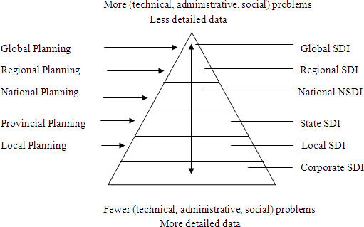
It is clear from the above model developed by Rajabifard that a global SDI is based on a regional SDI, a regional SDI is based on a national SDI, and a national SDI is based on a state SDI and so on. But it does not reflect how the scale of problems would vary along this hierarchy. It is believed that moving "up" in the SDI hierarchy will bring more socio-technical problems. The model presented by Rajabifard does not speak of technical problems such as interoperability, administrative problems such as jurisdictional issues, and social problems such as privacy issues while moving along the hierarchy.
For example, problems at a state SDI level will be less than problems at national SDI. One reason is that upper-level SDIs inherit from lower-level SDIs. The second reason is there will be many state SDIs, which means many organizations will be involved, and in the case of more organizations, legal, technical and cultural problems will arise. Every state has its own norms, rules and regulations. One state may categorize a certain type of information as classified and may not permit everyone to access it, whereas another state may offer open access to the same information. For example, Goa is an Indian state. The editor of Coordinates in August 2007 envisioned, "Goa being a costal state falls under the secret category and its maps can not be put on a network." Similarly, moving from "more detailed data" to "less detailed data" will offer significant technical problems. For instance, in the case of coastal lines, the generalization rules adopted by different states may be different. Therefore, the gravity of the situation will become more problematic and increase when going up in SDI hierarchy, which is presented graphically in figure 2.
At a higher administrative level, the need for small scale data arises but it poses more technical and administrative problems to spatial data managers. At the lower administrative level, the needed large scale data can be maintained with fewer technical, administrative and social problems, as is being done in Survey of Pakistan.
A special characteristic of spatial data is that they can be shared and used for many purposes other than the one for which they were originally produced. To facilitate their efficient sharing and reuse, they need to be properly managed in the form of an infrastructure - an SDI - as discussed, for example, by Crompvoets (pdf). This is one of the reasons that many countries are developing SDIs. de Man (pdf) pointed out the challenge of developing an infrastructure that needs to be used for different purposes and at different administrative levels:
"Development, adoption, and application of any information infrastructure will be different at different spatial (or geographical) levels because of the different social contexts. Technical and bureaucratic issues and values seem to dominate data handling at higher levels, whereas social issues and human values play a pronounced role at local levels of human interaction. Information infrastructures encompassing different geographical and administrative levels may face the problem of having to deal with different and sometimes conflicting institutional arrangements in different social systems."During discussion on various levels of SDI development, Don Grant and Williamson (2004) also found, "This presents a whole range of issues and experiences concerned with interoperability, jurisdictional responsibility, privacy …" (p.112). Similarly, Pickels (2004) argued for the same thought: "SDIs are also susceptive to geopolitical, economic, and socio-cultural issues and all the associated opportunities and threats of cyber spaces and interactions." Therefore, SDIs and other kinds of information infrastructure alike are different at different spatial (or geographical) levels because of differentiated social contexts. (de Man 2006).
 |
It is clear from the above model developed by Rajabifard that a global SDI is based on a regional SDI, a regional SDI is based on a national SDI, and a national SDI is based on a state SDI and so on. But it does not reflect how the scale of problems would vary along this hierarchy. It is believed that moving "up" in the SDI hierarchy will bring more socio-technical problems. The model presented by Rajabifard does not speak of technical problems such as interoperability, administrative problems such as jurisdictional issues, and social problems such as privacy issues while moving along the hierarchy.
For example, problems at a state SDI level will be less than problems at national SDI. One reason is that upper-level SDIs inherit from lower-level SDIs. The second reason is there will be many state SDIs, which means many organizations will be involved, and in the case of more organizations, legal, technical and cultural problems will arise. Every state has its own norms, rules and regulations. One state may categorize a certain type of information as classified and may not permit everyone to access it, whereas another state may offer open access to the same information. For example, Goa is an Indian state. The editor of Coordinates in August 2007 envisioned, "Goa being a costal state falls under the secret category and its maps can not be put on a network." Similarly, moving from "more detailed data" to "less detailed data" will offer significant technical problems. For instance, in the case of coastal lines, the generalization rules adopted by different states may be different. Therefore, the gravity of the situation will become more problematic and increase when going up in SDI hierarchy, which is presented graphically in figure 2.
 |
At a higher administrative level, the need for small scale data arises but it poses more technical and administrative problems to spatial data managers. At the lower administrative level, the needed large scale data can be maintained with fewer technical, administrative and social problems, as is being done in Survey of Pakistan.
From Our Homepage
Saying Farewell to an Amazing Journey
Communicating with Maps
Is There a GIS Career Ladder?
What does it mean to be geospatially smart? Series
Ways Real Estate and Property Developers Utilize Melissa GeoData for Data-Driven Decisions
Unlocking Value From Daily Satellite Imagery and Insights
Maximizing the Value of Your Address Data with Geo Addressing
How Indoor Mapping Enhances the Security of Smart Buildings
Look Ahead: AI, Location Intelligence and Efficiency
Collaboration Takes on Sea Level Rise & Dynamic Technology Environments
Brownies for Brownfields
Has Everything Been Mapped Already?
How Is Data Literacy Changing in an Artificial Intelligence Landscape
Portfolios for GIS Professionals: More Than Just Maps
How to Create a Distance Matrix in QGIS - A Step-by-Step Guide
7 Ideas for Bringing GIS into the K-12 Classroom
The Geography of Movement