Remember Placebase?
Perhaps you remember Placebase, the small company that this past spring came out with a Google Maps-like API offering without the Google Map-like license called Pushpin. It allowed, for a fee, commercial use, a fast and similar-to-Google Maps API, and turned a number of heads.
Now the company is back to announce the next round of innovation, offering up two new technologies that developers, and their end users, will find most attractive. The simplest way to explain where Placebase is going is to consider how its CEO, Jaron Waldman, speaks of Google Maps. He says, with respect, that Google Maps is "one size fits all" and aimed at the "mass consumer audience." He's the first to admit that Google has been successful with that vision. But, coming from a GIS consulting background, Placebase has a different audience, one needing more mapping capabilities, more control, more GIS.
Dynamic Layers: Layer Control Meets Fast Web Maps
A long time Placebase customer, the Fannie May Foundation, hosts DataPlace, a terrific site for looking at demographics on a map. (I wrote about it last spring.) The Fannie Mae Foundation's need for fast, on the fly, visually pleasing thematic maps prompted Placebase to solve that challenge for the client and then to build what it calls Dynamic Layers into Pushpin. (The Fannie Mae Foundation does not use Pushpin, but rather a custom application built by Placebase.) Dynamic Layers addresses the challenge of creating and delivering maps quickly (performance) with having them look nice (map aesthetics). Google Maps uses tiles to put pre-rendered, very pretty maps up on the browser screen quickly. Users can see the layers Google decides are relevant (and use the satellite image/hybrid tools). That's about it. At the other end of the spectrum, a powerful GIS can create a good looking thematic map of layers chosen by the user, but more slowly. Waldman wanted the users of the Pushpin API to have the speed, aesthetics and power of selecting layers. And, that's exactly what Dynamic Layers, an add-on to the Pushpin API, does.
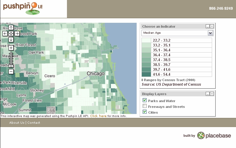 |
The data that Placebase offers is now accessible by developers on a layer by layer basis, even as is retains its speed by being tiled. The way to think of it is to imagine many GIS layers, all tiled up in the same way. The API allows developers to reach in, find the ones needed, fuse them into a single layer and push it out the browser very quickly. And, fear not, the developer can control which layer is on top and which others underneath so that choropleth shading does not obscure streets or water features, and text is readable. The tiles are available in 15 different zoom levels, so no matter how far in out the user zooms, the data comes back quickly in immediately useable form. Placebase is hosting a demonstration of Dynamic Layers.
I was curious why Dynamic Layers is not a new feature, but is rather a "for fee" extension. The bottom line? Waldman explains that the Placebase servers take a bigger hit and thus the company needs to charge more. The company is actually upping its storage and bandwidth now in preparation for new clients this fall.
RenderMap: Make Your Own Map Tiles
The other new technology also revolves around tiles. Rendermap is a service (also a product, more on that later) that will chop up any vector data, with user-defined symbology, at user-defined zoom levels, with user-defined georeferencing, into the map tiles noted above. Once the data are chopped up, Placebase can host the tiles for the client (to be used with the Pushpin API) or the client can load them onto it own server and use any tool to build applications.
So, in practice how does this work? A client who wants to use the vector data it owns or licenses in tiles sends it to Placebase along with other information (how the maps should be rendered, how many zoom levels are needed, the geographic extents, the projection of choice and other information). If the client is already a user of ArcGIS an MXD file can store the "how it should look information." Alternatively, the client can send on a description or sketch and have Placebase's cartographers create a custom look. The data and associated information is fed into Rendermap and, in time, a large number of tiles are spit out the other end. As might be expected the fee for creating the tiles depends on the size of the tiles, the number of zoom levels, the area, etc.
The folks at Fannie Mae actually have their own implementation of Rendermap; that group bought an implementation so it could render its own data, as needed. With coverage of the entire U.S. down to census tracts, rendering the full data set takes weeks, Waldman notes. A less detailed U.S. dataset may take fewer weeks. The City of Chicago? Days. The good news is that once this process is complete, the maps created on browsers are very, very fast, just like Google Maps!
Looking Ahead to ESRI User Conference
Placebase has some interesting times coming in the next few weeks. The company is working to secure more agreements with data providers to offer up their data in easy to use tiles ("the biggest lesson we learned from the launch" said Waldman) and it intends to launch both Dynamic Layers and Rendermap at the ESRI User Conference in San Diego in August.
My Take
Placebase is tapping into a few deep-seated needs of the GIS community, ones that may or may not come up in the informal mashup community and turning them into advantages.
- Control - While the existing mapping APIs are quite nice, GIS developers regularly point to the lack of control of interface. With dynamic layers much of that control is in the mix.
- Rendering - The look of the data is important. Each city, state, company has a look that it determines is appropriate for its work. All Google Maps mashups look the same. All those created with data styled and rendered by Rendermap will likely look different!
- Freedom - While Placebase offers its own API, there's no reason users who create tiles with Rendermap can't or won't use other tools for publishing the data. They might choose ArcIMS or MapServer (Ka-Map) or other tools.
Placebase has its niche since those issues are not currently ones of interest to Google, Microsoft, Yahoo or Ask.com. Placebase is perhaps becoming the mapping API provider for the GIS community, while these other players cater to a different clientele.