Steve Walden is Vice President and General Manager of
the Centrus Division at Group 1 Software,
(a Pitney Bowes Company).He is responsible for Group 1's business
geographics product line.Walden has more than 10 years of management
experience in the GIS and Business Geographics field, starting in the
early 1990's at Strategic Mapping.
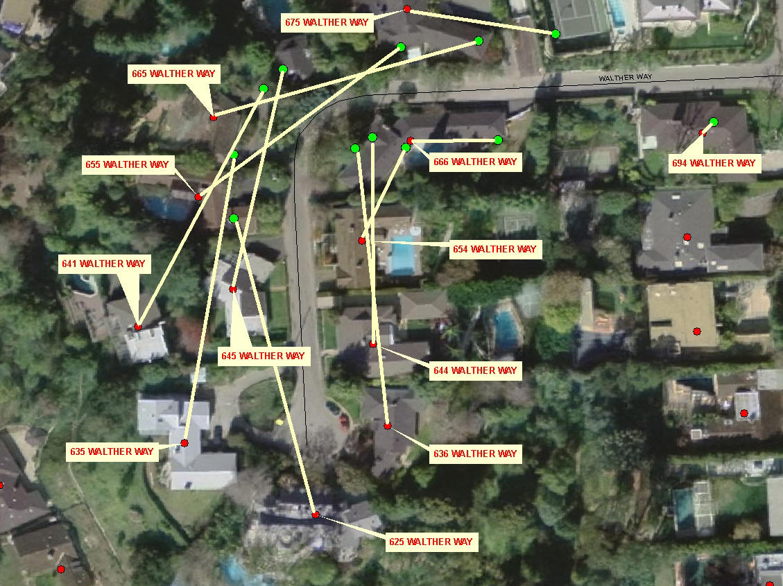
I contacted Walden to follow up on a substantial software and data upgrade to Group 1's GeoStan application.GeoStan is the company's address standardization and geocoding program.Until now, it has provided geocoding only down to the "traditional" block-face level.By plugging in new data points from Tele Atlas, geocoding is now possible at the point level (e.g.centroid of parcel or building footprint). Walden explained how this is done, and what it means to Group 1's customers.
Nora Parker (NP): Most street-level geocoding is done by interpolation along a block face, which generates a "good enough solution" for many applications.The GeoStan "Point-Level Option" incorporates point-level data from the centroids of parcels and buildings, and thus improves the geocoding accuracy.How is this done? Does the Tele Atlas data now incorporate some kind of address-based centroid?
Steve Walden (SW): Tele Atlas is providing to us something on the order of 46 million points in the US, some of which are building centroids and some are parcel centroids.They have acquired this data from county parcel maps and aerial images over the years and now they're providing it to us.We worked with the data quite a bit to understand the ramifications of having this improved quality.Check out the two examples shown below.In the first one, you can see how far the address on Sepulveda Boulevard (in Los Angeles) is off if you're just geocoding to the block face.In the Walther Way example, which is a residential area, there are lines showing far off the geocoded point would be based on block-face geocoding as compared to point-level geocoding.This one's a good example because it's on a cul-de-sac, which have always been tricky for block-face geocoding.
As you know, different applications require different levels of
accuracy.In some applications, ZIP Code centroids are adequate.Other
applications require perfection, and the best we could provide, as an
industry, was an interpolated block-face geocode.Moving to the true
point level, which in some cases is at the building centroid and others
at the parcel centroid, gets us to what I would consider to be the
perfect geocode.We are very pleased to be the first company in the
industry to provide an optional feature for our geocoding engine that
takes advantage of this new data set from Tele Atlas.
We found the overwhelming majority of point geocodes were well within 100 feet of the block-face geocode, but there were also cases where there was a lot of difference, like on Sepulveda.So, getting back to your question about what this means to users.Frankly, many industries may not care.For example, this level is detail isn't at all important for most retail applications.But when you get into applications like insurance underwriting, flood determination and, and Call-Before-You-Dig uses, a few feet can make a very big difference.I can't even imagine how you could get a better geocode.
NP: With the data now built into the Tele Atlas street database, will GeoStan's "only such solution in the marketplace" status be quickly disrupted by competitors using the same data from Tele Atlas?
SW: I am certain that other providers will follow our lead now that we have moved the bar higher, just as others did after we were the first company to USPS CASS Certify [the US Postal Service's Coding Accuracy Support System] our geocoding engine over 10 years ago.It is a natural next step in the evolution of geocoding.It is important to note that GeoStan is able to cascade from one dataset to another, meaning it can first check for a match in the Point Data, and if none is found, fall back to an interpolated geocode using street centerline data. Features such as these allow us to keep ahead of our competition.
NP: How does the pricing model work for the GeoStan Point-Level Option? - Presumably it's a lot more expensive than the block-interpolation option?
SW: We do not publish a price list for our solutions, but it is safe to say that it is more expensive than our standard engine.Many customers will never have the need to get to this level of accuracy, but for those who do, we believe the value of the solution will far outweigh the cost.
NP: Which industries do you expect will be early adopters, and how will they justify the increase in price?
SW: As I mentioned before, many geocoding applications require perfection, but block-face interpolation was the best available technology.We developed an engine we call the Geographic Determination Library to help organizations to compensate in the places where a variance measured in feet could be costly.Flood determination and property and casualty insurance companies are our biggest users of this engine, and we anticipate this to be very useful to utilities (e.g., Call-Before-You-Dig).Now, since we are geocoding to the actual location rather than to the block face, we can increase the number of policies that can be written without human intervention.
But we also believe that the Internet mapping sites, which are all adding great features including aerial imagery, will realize benefits. I think there is significant value in having the "dot" appear on top of the house or parcel in a much more consistent way, which reduces user calls and increases trust in the accuracy of the map.
NP: While point-level addressing is more accurate, the "polygon against which you are measuring" (the flood plain "boundary," for example,) is still very "fuzzy." Does "putting the point right on top of the house" really help in such an instance?
SW: In the past, we had two "fuzzy" features we were comparing.We are eliminating one area of "fuzziness," making the confidence in the overall solution much higher.If a flood determination company is 90% confident in the geocode, and 90% confident in the flood polygons, that implies an 81% level of confidence.They are living with this today.We now boost that confidence to 90%, I guarantee that they will stand up and take notice.And by the way, every one of our flood determination customers have expressed a very strong interest in this product.
I contacted Walden to follow up on a substantial software and data upgrade to Group 1's GeoStan application.GeoStan is the company's address standardization and geocoding program.Until now, it has provided geocoding only down to the "traditional" block-face level.By plugging in new data points from Tele Atlas, geocoding is now possible at the point level (e.g.centroid of parcel or building footprint). Walden explained how this is done, and what it means to Group 1's customers.
Nora Parker (NP): Most street-level geocoding is done by interpolation along a block face, which generates a "good enough solution" for many applications.The GeoStan "Point-Level Option" incorporates point-level data from the centroids of parcels and buildings, and thus improves the geocoding accuracy.How is this done? Does the Tele Atlas data now incorporate some kind of address-based centroid?
Steve Walden (SW): Tele Atlas is providing to us something on the order of 46 million points in the US, some of which are building centroids and some are parcel centroids.They have acquired this data from county parcel maps and aerial images over the years and now they're providing it to us.We worked with the data quite a bit to understand the ramifications of having this improved quality.Check out the two examples shown below.In the first one, you can see how far the address on Sepulveda Boulevard (in Los Angeles) is off if you're just geocoding to the block face.In the Walther Way example, which is a residential area, there are lines showing far off the geocoded point would be based on block-face geocoding as compared to point-level geocoding.This one's a good example because it's on a cul-de-sac, which have always been tricky for block-face geocoding.
 |
 |
We found the overwhelming majority of point geocodes were well within 100 feet of the block-face geocode, but there were also cases where there was a lot of difference, like on Sepulveda.So, getting back to your question about what this means to users.Frankly, many industries may not care.For example, this level is detail isn't at all important for most retail applications.But when you get into applications like insurance underwriting, flood determination and, and Call-Before-You-Dig uses, a few feet can make a very big difference.I can't even imagine how you could get a better geocode.
NP: With the data now built into the Tele Atlas street database, will GeoStan's "only such solution in the marketplace" status be quickly disrupted by competitors using the same data from Tele Atlas?
SW: I am certain that other providers will follow our lead now that we have moved the bar higher, just as others did after we were the first company to USPS CASS Certify [the US Postal Service's Coding Accuracy Support System] our geocoding engine over 10 years ago.It is a natural next step in the evolution of geocoding.It is important to note that GeoStan is able to cascade from one dataset to another, meaning it can first check for a match in the Point Data, and if none is found, fall back to an interpolated geocode using street centerline data. Features such as these allow us to keep ahead of our competition.
NP: How does the pricing model work for the GeoStan Point-Level Option? - Presumably it's a lot more expensive than the block-interpolation option?
SW: We do not publish a price list for our solutions, but it is safe to say that it is more expensive than our standard engine.Many customers will never have the need to get to this level of accuracy, but for those who do, we believe the value of the solution will far outweigh the cost.
NP: Which industries do you expect will be early adopters, and how will they justify the increase in price?
SW: As I mentioned before, many geocoding applications require perfection, but block-face interpolation was the best available technology.We developed an engine we call the Geographic Determination Library to help organizations to compensate in the places where a variance measured in feet could be costly.Flood determination and property and casualty insurance companies are our biggest users of this engine, and we anticipate this to be very useful to utilities (e.g., Call-Before-You-Dig).Now, since we are geocoding to the actual location rather than to the block face, we can increase the number of policies that can be written without human intervention.
But we also believe that the Internet mapping sites, which are all adding great features including aerial imagery, will realize benefits. I think there is significant value in having the "dot" appear on top of the house or parcel in a much more consistent way, which reduces user calls and increases trust in the accuracy of the map.
NP: While point-level addressing is more accurate, the "polygon against which you are measuring" (the flood plain "boundary," for example,) is still very "fuzzy." Does "putting the point right on top of the house" really help in such an instance?
SW: In the past, we had two "fuzzy" features we were comparing.We are eliminating one area of "fuzziness," making the confidence in the overall solution much higher.If a flood determination company is 90% confident in the geocode, and 90% confident in the flood polygons, that implies an 81% level of confidence.They are living with this today.We now boost that confidence to 90%, I guarantee that they will stand up and take notice.And by the way, every one of our flood determination customers have expressed a very strong interest in this product.
From Our Homepage
Saying Farewell to an Amazing Journey
Communicating with Maps
Is There a GIS Career Ladder?
What does it mean to be geospatially smart? Series
Ways Real Estate and Property Developers Utilize Melissa GeoData for Data-Driven Decisions
Unlocking Value From Daily Satellite Imagery and Insights
Maximizing the Value of Your Address Data with Geo Addressing
How Indoor Mapping Enhances the Security of Smart Buildings
Look Ahead: AI, Location Intelligence and Efficiency
Collaboration Takes on Sea Level Rise & Dynamic Technology Environments
Brownies for Brownfields
Has Everything Been Mapped Already?
How Is Data Literacy Changing in an Artificial Intelligence Landscape
Portfolios for GIS Professionals: More Than Just Maps
How to Create a Distance Matrix in QGIS - A Step-by-Step Guide
7 Ideas for Bringing GIS into the K-12 Classroom
The Geography of Movement