 BAE Systems
10920 Technology Place
San Diego, CA 92127
Phone 877-762-3873
FAX 858-592-5309
On March 23 I had a discussion with Dr. A. Stewart Walker, Director of Marketing for BAE Systems, about ClearFlite. ClearFlite is a product that uses stereo imagery to locate potential obstacles to safe flight and generates both graphic and tabular outputs of those objects. ClearFlite is an extension to the BAE product Socet Set, its photogrammetric software.
ClearFlite was created in response to a Congressional initiative resulting from the April 3, 1996 aircraft accident in Croatia where Secretary of Commerce Ron Brown and 30 other passengers and crew were killed. A major cause of this accident was that the navigation charts for the Dubrovnik airport were grossly out of date or non-existent and, therefore, hazards to flight were not well identified.
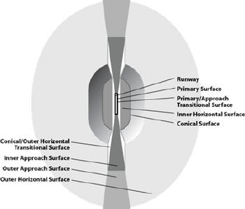
ClearFlite works primarily within a federal regulation concept called the “obstruction identification surface” (OIS). The OIS is an imaginary surface defining the obstruction area around an airfield and can be represented as a 3D surface of the airport including the instrument approach paths and the surrounding environment. Vertical obstructions are those features that could intrude into a flight path.
According to BAE company literature, ClearFlite uses soft-copy photogrammety, GIS and geospatial analysis to identify and collect vertical obstructions. Here are some of the things ClearFlite does:
- Automatically create 3D vector and elevation models of the OIS over any runway
- Provide a stereo view of terrain and vertical obstructions around any airfield
- Continuously display elevation and height above the OIS
- Provide a visual indicator when objects are above or below the OIS
- Automatic population of critical attributes
- Automatic delineation of terrain obstructions
This is the workflow that ClearFlite supports.
- Identifying and inputting runway end points
- Automatically building 3D OIS models
- Building a reflective surface elevation model - similar to a LiDAR database
- Intersecting the OIS and an elevation model - this automatically identifies terrain obstacles
- Extracting the vertical obstructions in stereo - attributes are automatically applied to obstructions
- Exporting data to GIS/visualization applications
 |
Remember that the ClearFlite process begins with stereo imagery like this (the actual image used would be in stereo).
Hal Reid (HR): Looking at the literature on ClearFlite, it appears to be an add-on to Socet Set, BAE’s photogrammetry product, and is essentially a functionality extender allowing for the creation of 3D terrain modeling in an airport environment. (I ask this question because it appears that the expertise to run Socet Set is not trivial and ClearFlite could not be a stand-alone application.)
Dr. Stuart Walker (SW): Socet Set is a high end, market-leading product. However, we do have users of ClearFlite without previous experience with Socet Set and, of course, we have many existing customers using ClearFlite. If pre-registered data is used, the level of expertise required to use ClearFlite is reduced.
HR: Does BAE also provide an end-to-end process for those airport authorities that may not have the technical expertise to create their own output?
SW: ClearFlite is a product and our main focus is on selling it as a product. Of course, BAE can provide services and consulting for ClearFlite users.
HR: How is the output applied? Are the digital representations used both on the ground in an FAA control center or even control tower and in the cockpit?
SW: The output of ClearFlite is a long workflow depending on the governing entities’ processes (FAA or others) and results in a set of procedures. (Ed note: In the cockpit this could be used during the procedure for approaching the airfield.) The OIS may contain warnings of obstructions and the prescribed flight paths (bearings and altitudes) for instrument approaches. Procedures are developed over time and experience in the airspace.
HR: The impression I get from the product literature is that ClearFlite all but eliminates the need for a field survey of the airport environment to assess and create 3D representations of vertical obstructions. Is there also field verification of vertical obstacles?
SW: Yes, there is also field verification. What is important to understand is that ClearFlite reduces the total process time by identifying obstacles without interfering with airport operations. No interfering with flight operation, no safety issues with people on the ground, no time lost. When the field verification is done, it is highly targeted and focused. Field verification also allows for the identification of obstacles that may have been put in place after the stereo photos used in the ClearFlite process were taken. In order to keep the data current, periodic reviews (reprocessing) have to be done.
HR: There seems to be a standard procedure in mapping, locating and creating the airport environment. Is this just to make the workflow easier or is it to comply with Part 77 (an FAA regulation)?
SW: No, the procedures are determined by the governing authority, not the user of ClearFlite. There needs to be a systemic approach, it is both complex and simple.
HR: I see in the literature that Socet Set and ClearFlite interface with ESRI products. Do you also support and interface with photogrammerty products from other vendors?
SW: Yes, we output to ESRI Shape Files and other vendors’ sensor and file formats.
HR: You have processed 800 airports around the world using ClearFlite. Are there criteria for selecting these airports; for example, number of potential obstructions (most dangerous airports), traffic volume, traffic type (e.g. military, DOD, government officials), number of runways, etc?
SW: Authorities like the FAA, DOD and others do this based on traffic, future use, etc. The main drivers seem to be economic and future use. For example, IATA (the International Air Transport Association) has identified 13 airports in South America as having potential for future growth which are to be processed by ClearFlite.
HR: While the complexity of terrain along with available data are certainly factors, how long is a typical process to create the map and catalog of obstructions for an airport?
SW: Once imagery has been obtained, this can be only a few days in creating the OIS, identifying the obstructions and doing the field verification. (Ed note: you can imagine this is a considerably shorter time-frame than doing a field survey and also having people on the ground during flight operations.)
HR: A question on data sourcing. Here in the U.S., aerial photography and other related data are fairly easy to acquire. What special problems do you have in areas that are not adjacent to major population areas that have lots of current data?
SW: The problem is not generally the availability, but the currency and the accuracy of the imagery. We can use commercial satellites for much of the world, making imagery pretty straightforward. However, there are still some areas that are remote or not (politically) accessible.
HR: While the imagery produced from ClearFlite is impressive, have there been any training issues with the users of your output so that what is represented is clearly understood? Do users who experience multiple airports find it necessary to be orientated to each representation?
SW: Training is easier for new users with pre-registered imagery. The output is a set of attributes as a list of obstructions with coordinates which is identical to what might have been created in a field survey. So people familiar with the data do not find issues in transitioning to ClearFlite output. Remember we have an advantage in that this is a much faster process and we have the topography and it is also much safer, as there is no conflict with aircraft on the ground.
Summary
There are two key points with ClearFlite. First, it is cool technology. Second, it is put to use making flying safer in a manner that is totally transparent to the end user - a passenger on any airplane. The fact that it can produce a list of vertical obstructions along with the associated graphics in a few days means that more airports in even remote parts of the world become safer sooner. BAE recently received an award from the 16th annual ATC Maastricht Exhibition and Conference for excellence in air traffic safety (Feb, ’06). This is an example of how this software has made a major contribution in its field. The next time you are flying into an airport when the visibility is low, your comfort level should be increased by knowing that someone has been there and mapped out all the vertical obstructions, and the pilot has them, along with the proper procedures, on his approach plate.
From Our Homepage
Saying Farewell to an Amazing Journey
Communicating with Maps
Is There a GIS Career Ladder?
What does it mean to be geospatially smart? Series
Ways Real Estate and Property Developers Utilize Melissa GeoData for Data-Driven Decisions
Unlocking Value From Daily Satellite Imagery and Insights
Maximizing the Value of Your Address Data with Geo Addressing
How Indoor Mapping Enhances the Security of Smart Buildings
Look Ahead: AI, Location Intelligence and Efficiency
Collaboration Takes on Sea Level Rise & Dynamic Technology Environments
Brownies for Brownfields
Has Everything Been Mapped Already?
How Is Data Literacy Changing in an Artificial Intelligence Landscape
Portfolios for GIS Professionals: More Than Just Maps
How to Create a Distance Matrix in QGIS - A Step-by-Step Guide
7 Ideas for Bringing GIS into the K-12 Classroom
The Geography of Movement