Cavendish House
Cambridge Business Park
Cambridge
CB4 0WZ
UK
+44 (0) 1223 420414
http://www.laser-scan.com
There is a perpetual quest to "catch the wave" when marketing a new product. The quest is to be on the leading edge of demand, riding the wave of acceptance that is just beginning to crest. Everyone tries to do this, but not everyone succeeds. The recent release of Radius Studio on January 25 could hit the wave just right. Data precision expectations are up across the board – Google shows your address; citizens expect to see an accurate map of their properties on their local government’s Web site; and businesses expect precise and accurate location data on their assets.
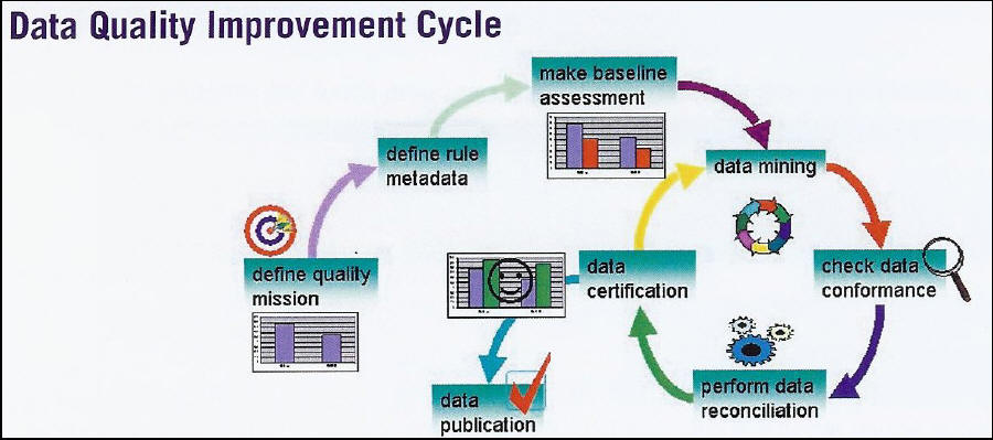
Accurate data are business critical in the straight-through processing that delivers efficiency in the financial markets. Over the last 10 to 15 years, spatial data have been collected mainly to produce maps. These data are now being more fully utilized, beyond what was originally envisioned, in electronic decision making far from the point of collection. These data need to be certified as fit for purpose.
Laser-Scan’s product literature suggests that data need to be converted to information, then knowledge, and finally to wisdom.
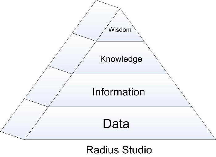 |
"Knowledge within an organization is often incredibly difficult to access. It is inside people’s heads, hidden away in the end application code, or tucked away in paper specifications. It is therefore important for the people who produce data and information to capture that knowledge, organize it and make it visible to others. Critically, this allows the knowledge to be validated to make sure it is indeed accurate. … Radius Studio provides the framework for knowledge engineering for spatial technologies." (Author note: italics are mine.)In a way, Radius Studio does for spatial data what Business Intelligence does for tabular data. And it even crosses over into the business intelligence world, as it can also perform data mining, establish rules, provide reporting and even automatically fix non-conforming objects.
How it works
The architecture looks like this.
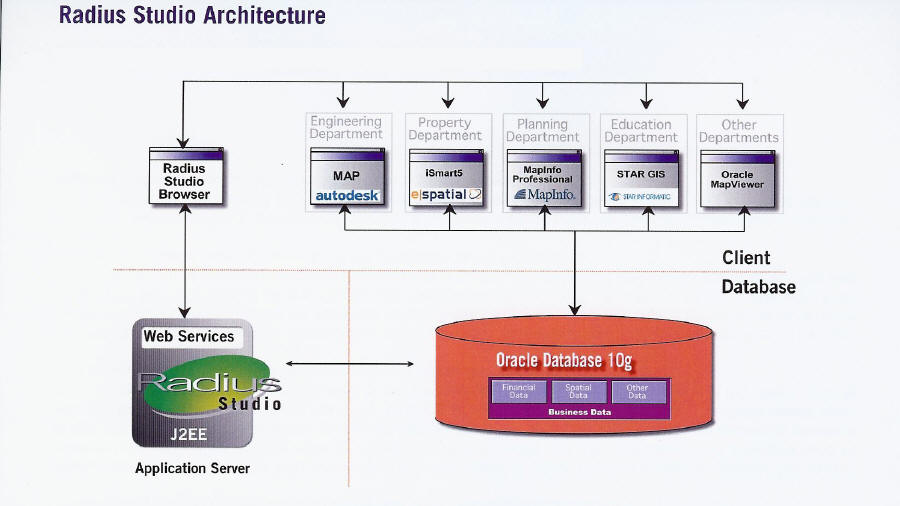 |
Radius Studio is currently designed to support standard spatial software packages that write directly to Oracle9i or 10g. It processes data that are already written to Oracle, corrects all data, and establishes a rule base for data correction and the actions necessary for keeping the data accurate.
 |
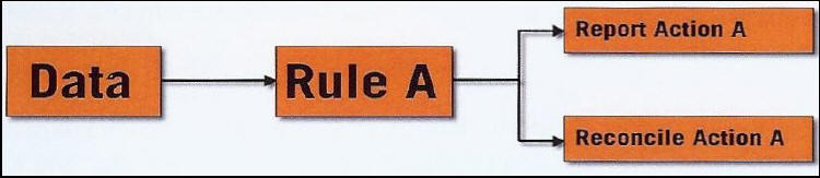
The Spatial Rules Engine allows the user to define how data are to be processed, and the required level of accuracy and the conditions under which the data are to exist.
 |
The complete Radius Studio suite consists of three elements.
- Knowledge Management Tool
- Spatial Rules Engine
- Domain Discovery Tool
 |
In addition, other tools extend the basic product for additional data cleaning, conflation and simplification, with more complex generalization functionality planned. There is an extensible API package that uses Java and XML, which means that other 3rd party tools can be plugged in to the component architecture.
- Data Stores – Defines connections to the data source that is to be processed by Radius Studio
- Rule Discovery – Data discrepancy pattern recognition functionality
- Rules – The rule builder for defining what will govern the nature of the data, and includes conditions, values, relationships and spatial relationships
- Actions – Similar to the rule builder interface but allows for rule changes and more complex functions – e.g. math, conversions, bit manipulation, etc.
- Action Maps – Used to connect rules to actions
- Sessions – Allows for the creation of structured workflows (a sequence of tasks)
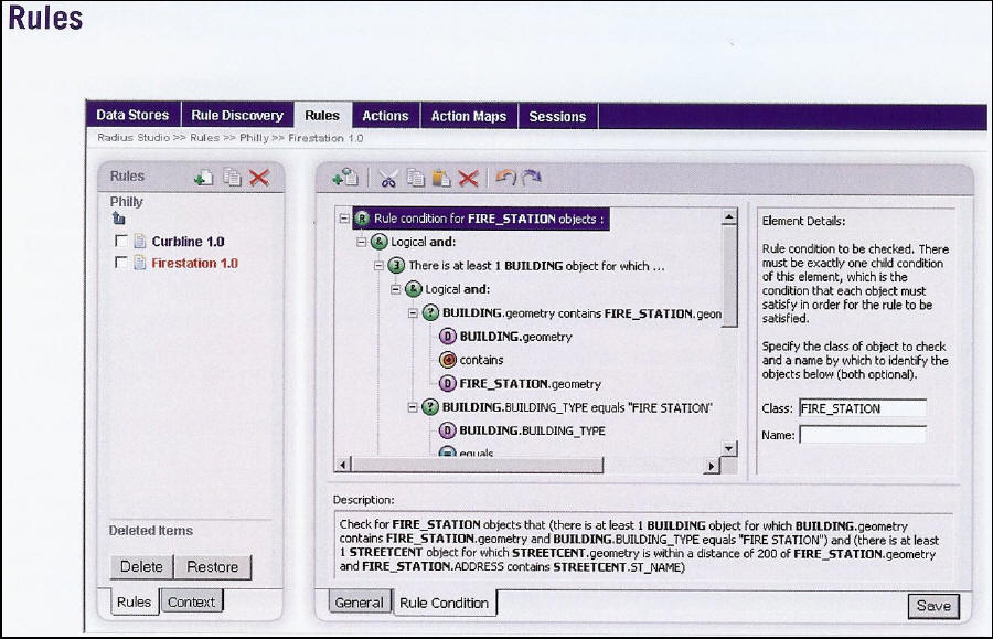 |
As you can see, rules are created using an interface similar to Windows Explorer, with the hierarchical structure of each rule created one step at time. The plain text translation appears in the description box as the rule is created, so if your "query similar" input won’t run, you can fix it before you attempt to run it again.
Spatial data quality is important because it provides the foundation for coherent and reliable location intelligence. Since data precision is the current wave of user expectations, Radius Studio is well positioned to catch it. I think the Laser-Scan people do a good job of explaining what this product does in this paragraph from the product literature:
"Radius Studio is a data integration suite that provides organizations with a central enterprise-wide rules technology and collaborative knowledge base. Rules are centrally defined and can be used to verify and enhance data at key points in the maintenance lifecycle to ensure it can safely pass on to the next stage. This allows users to graphically build and manage rule-based processing workflows for spatial data. It provides a highly dynamic framework that allows users to accommodate business change without costly system re-engineering."
From Our Homepage
Saying Farewell to an Amazing Journey
Communicating with Maps
Is There a GIS Career Ladder?
What does it mean to be geospatially smart? Series
Ways Real Estate and Property Developers Utilize Melissa GeoData for Data-Driven Decisions
Unlocking Value From Daily Satellite Imagery and Insights
Maximizing the Value of Your Address Data with Geo Addressing
How Indoor Mapping Enhances the Security of Smart Buildings
Look Ahead: AI, Location Intelligence and Efficiency
Collaboration Takes on Sea Level Rise & Dynamic Technology Environments
Brownies for Brownfields
Has Everything Been Mapped Already?
How Is Data Literacy Changing in an Artificial Intelligence Landscape
Portfolios for GIS Professionals: More Than Just Maps
How to Create a Distance Matrix in QGIS - A Step-by-Step Guide
7 Ideas for Bringing GIS into the K-12 Classroom
The Geography of Movement