Oracle has integrated its spatial and location software
with Oracle Business Intelligence Suite Enterprise Edition Plus (Oracle
BI Suite EE Plus), Oracle's standards-based suite of BI infrastructure
and tools products, providing customers with added value from location
intelligence and improved decision support for business processes
throughout the enterprise. Initial customer implementations are in the
insurance industry and public sector constituent services, and interest
is expected to grow rapidly in other verticals.
With this new support, customers can:
Oracle Locator and Oracle Spatial
Oracle Locator is a feature of Oracle Database (all editions) that provides core location functionality needed by most customer applications. Oracle Spatial is an option for Oracle Enterprise Edition that provides advanced spatial features to support high-end GIS and LBS solutions. In addition to tools in Oracle Locator, Oracle Spatial features include raster and 3D data management, spatial Web services, topology, network data modeling, RDF and semantic Web capabilities. Oracle Spatial and Oracle Locator support relevant Open Geospatial Consortium (OGC) standards.
Oracle Application Server MapViewer
Oracle Application Server MapViewer is a J2EE service for rendering maps using spatial data managed in Oracle Database by Oracle Spatial and/or Locator. MapViewer provides services and tools that hide the complexity of spatial data queries and cartographic rendering while providing customizable options for more advanced users. MapViewer is designed to integrate with location-based services and applications, and supports relevant Open Geospatial Consortium (OGC) standard specifications.
Oracle Business Intelligence
Oracle Business Intelligence is a portfolio of technology and applications that provides the industry's first integrated, end-to-end Enterprise Performance Management System, including category-leading financial performance management applications, operational BI applications, BI foundation and tools, and data warehousing.
With this new support, customers can:
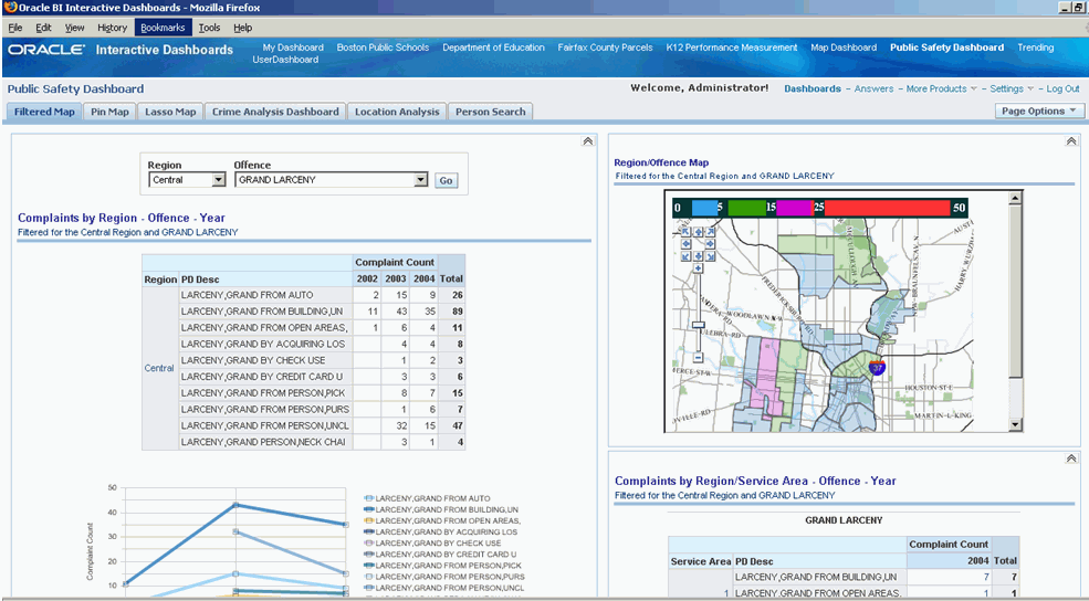
- Display data with a geographic dimension or location on a map
- Display color-coded regions as thematic maps
- Show point-based information, e.g. sales locations within territories
- Zoom, pan, drill to additional map detail
- Use the Map to interact with other Oracle BI Suite EE Plus Dashboard elements
- Dashboard prompts drive map content
- Drill-down and Navigation drive map content
- Interaction with the Map updates other Dashboard content
- Show additional related contextual information with mouse rollovers on maps
 |
Oracle Locator and Oracle Spatial
Oracle Locator is a feature of Oracle Database (all editions) that provides core location functionality needed by most customer applications. Oracle Spatial is an option for Oracle Enterprise Edition that provides advanced spatial features to support high-end GIS and LBS solutions. In addition to tools in Oracle Locator, Oracle Spatial features include raster and 3D data management, spatial Web services, topology, network data modeling, RDF and semantic Web capabilities. Oracle Spatial and Oracle Locator support relevant Open Geospatial Consortium (OGC) standards.
Oracle Application Server MapViewer
Oracle Application Server MapViewer is a J2EE service for rendering maps using spatial data managed in Oracle Database by Oracle Spatial and/or Locator. MapViewer provides services and tools that hide the complexity of spatial data queries and cartographic rendering while providing customizable options for more advanced users. MapViewer is designed to integrate with location-based services and applications, and supports relevant Open Geospatial Consortium (OGC) standard specifications.
Oracle Business Intelligence
Oracle Business Intelligence is a portfolio of technology and applications that provides the industry's first integrated, end-to-end Enterprise Performance Management System, including category-leading financial performance management applications, operational BI applications, BI foundation and tools, and data warehousing.
From Our Homepage
Saying Farewell to an Amazing Journey
Communicating with Maps
Is There a GIS Career Ladder?
What does it mean to be geospatially smart? Series
Ways Real Estate and Property Developers Utilize Melissa GeoData for Data-Driven Decisions
Unlocking Value From Daily Satellite Imagery and Insights
Maximizing the Value of Your Address Data with Geo Addressing
How Indoor Mapping Enhances the Security of Smart Buildings
Look Ahead: AI, Location Intelligence and Efficiency
Collaboration Takes on Sea Level Rise & Dynamic Technology Environments
Brownies for Brownfields
Has Everything Been Mapped Already?
How Is Data Literacy Changing in an Artificial Intelligence Landscape
Portfolios for GIS Professionals: More Than Just Maps
How to Create a Distance Matrix in QGIS - A Step-by-Step Guide
7 Ideas for Bringing GIS into the K-12 Classroom
The Geography of Movement