Radius topology is a unique, new technology developed by Laser-Scan for better efficiency of an Oracle Spatial database.We asked Laser-Scan about this technlology to provide a few more details.
1.Is Radius Topology comprised of a specific Oracle9i schema that provides speed and efficiency?
Laser-Scan's topology management was originally developed for the proprietary Gothic object-oriented environment. The topology libraries that have been developed over the last 12 years are now being made available in an Oracle9i database.These libraries store topological data in Oracle tables using open, ISO-compliant schema.
2.What other tools (XML?) were used to create Radius Topology? Is the primary development platform Oracle or other?
Oracle is the primary development platform.PL/SQL is used to write the domain index for queries, triggers, etc.The topology calculations are implemented in C.Java Swing is used for user interfaces, such as metadata configuration wizards.
3.Is Oracle Spatial required in order to obtain maximum efficiency?
The Oracle spatial type, i.e.Oracle SDO geometry available in both Oracle Locator and Oracle Spatial products, is a prerequisite for Radius Topology.
4.How will users of ESRI ArcGIS software access Oracle9i with Radius Topology? Through SDE only? Please explain.
Any GIS vendor that can offer direct read/write access to the Oracle spatial type will work with Radius Topology.
5.How will users of Intergraph GeoMedia software access Oracle9i with Radius Topology? A separate data server or with the existing Oracle Spatial data server? Please explain.
There are no changes required for the connection mechanism between the client and the database since Radius Topology uses standard Oracle types.Users will have the same look and feel for all products with added topological intelligence.It is a transparent solution.
Radius Topology adds a few additional tables in Oracle Spatial to provide topological awareness to MapInfo Professional, GeoMedia Professional and we are currently undertaking a technical evaluation with Autodesk Map.MapXtreme has also been successfully tested and demonstrated. Work is ongoing with WebMap and Autodesk MapGuide.
6.How will users of a non-topologically
structured databases need to structure or convert their data in order to
take advantage of Radius Topology?
No change or restructuring is required. Radius Topology can work with any feature model.Triggers and references will connect existing 'spaghetti' or unstructured data with topological data and apply structuring rules to ensure data consistency.Work may then be required to correct data errors identified by Radius Topology that cannot be fixed by snapping.Radius Topology will set the business rules 'once' that will apply to all new data.Radius Topology automatically maintains the relationship between features and topology on the server-side.
As mentioned previously, the new topological data is stored in tables using the standard Oracle spatial type.Clients can view the topological structure without modification. The key to this relationship is the underlying table structure containing node, edge and face tables set out in accordance with the ISO19107 standard.
7.Can you give an example of an OGC Web Map Server? I don't know that any vendor, with the possible exception of Intergraph, is certified for web server? Please clarify.
There are many examples, as advertised
on the OGC site including Laser-Scan.Go to
http://www.opengis.org/cgi-bin/implement.pl
Select 'Web Mapping Server' from
the View by Specification: drop list.
Then click on 'Filter Implementations
View'.
9.Is Radius Topology targeted at providing a foundation for Web Services using spatial information, as OGC has outlined and demonstrated at http://www.wmsviewer.com/
Radius Topology is the first product in the Radius suite of products.The suite, or family, of products will leverage the extensive geospatial capabilities and proven solutions from Laser-Scan's object-oriented technology.It will open up this technology to the mainstream Information Technology market.
The Radius family will be purely server-side technology that will lend itself perfectly to web services. Radius Topology provides the underpinnings to create high performance (scalable) servers for heavy-duty spatial query services, such as LBS via WMS/WFS.
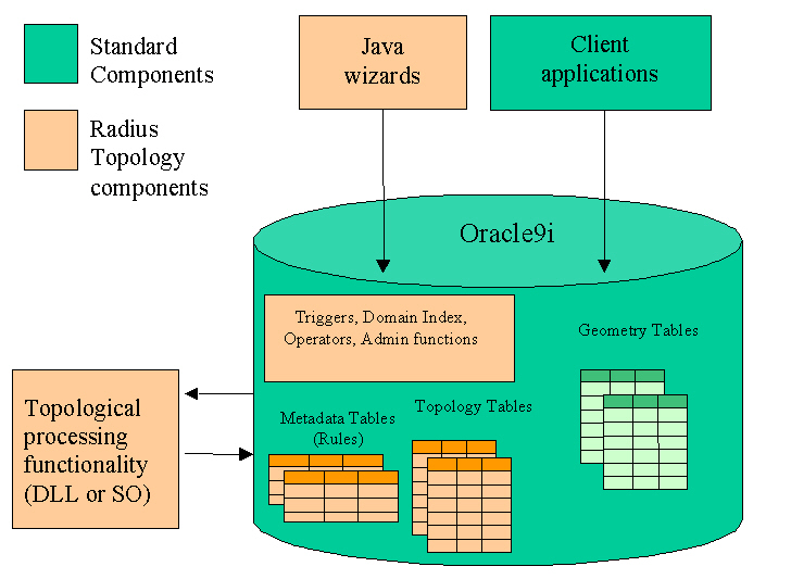
10.Please provide a system architecture diagram if possible.
Radius Topology provides the following components:
Functionality
- A DLL (on Windows) or a shared object (on Solaris) that implements the topological rules and behaviours.
- SQL scripts that create packages, functions, triggers and a domain index, plus procedures to create and maintain Radius metadata tables.
- SQL scripts that create some simple features and perform a test to prove the installation.
- Java classes and start-up scripts that provide a Java GUI that allows users to set up topological rules and tolerances and to identify the data that needs to be topologically structured.
- Files for National Language Support, and un-installation.
Deployed Components
Click HERE
for a Product Brochure in PDF format
Other information available includes performance and quality documentation.