ESRI, Inc.
380 New York Street,
Redlands, CA 92373
Tel: 1-800-970-0033
http://www.esri.com
Introduction
ESRI's has just released BusinessMAP Travel Edition 2.0.While this
product is targeted as the mapping tool for the Business Traveler, it has
much more to offer.This is the first product in this price range that
can provide almost seamless transitions from the desktop to the web and
to the PDA.Out of the box, it supports Palm devices, allows for routing
results, shows business locations and route directions, all of which can
be moved to a Palm.Extremely useful is the Maptech topographic map and
aerial photo add-on, which automatically retrieves data directly from the
web.This data is pre-registered so it lines up with the existing map layers.
This is a high-value product in terms of basic functionality, the amount
of supplied data and the ability to incorporate as a source, a web server
for external data.
Product Scope
This is a product that you should have as a standard tool for finding
points of interest, making maps and creating directions.It is designed
for the average person to use.The learning curve is flat, and if additional
training in necessary, understanding more about the product functionality
is aided by the use of video demonstration.When was the last time you
went to a GIS movie?
Most products in this price range come with a set of data, mostly TIGER and you can not add very much to what you get initially.This is not true for BusinessMAP Travel Edition and this is where the value lies.
Supplied Data
The product is supplied with an exceptional amount of data for this
price point and you can add more.For example, included in the box is the
following:
- GDT Dynamap 2000®/Transportation - Accurate street centerlines that actually curve.Up-to-date boundary files (e.g.Zip codes with demographics)
- Dun & Bradstreet's 16 million business listings - you can search through this database by SIC code, business name, address, city, state, ZIP Code, telephone number and latitude/longitude, then select and map.
- Boundary files down to the Zip Code level with basic demographics and all the standard points of interest.
With Canadian and European data sets, this is a true international product. It also reads geo-referenced raster files that can provide an image to support the road and boundary network.
As for the DEMs, you can add 150+ City level maps for only $29.95 (pre-registered).
Among the add-on choices are Aerial Photography and Topographic Maps from Maptech.(http://www.info.maptech.com/BusinessMAP). These are seamlessly integrated, so that based on the level of zoom, these layers will automatically download from the web and display in your map.
[Note: BusinessMAP Travel Edition also reads shape files, as well as a number of graphic formats, so if you already have data in those formats, you can load those files.]
Standard Office Product file formats work too, so you don't have to move all your tabular data to a DBF format.Files that already reside in Excel, Access, FoxPro, etc.will work.If your files have a geographic component, you can also create map points and labels from those files with a built in wizard.
Functionality
BusinessMAP Travel Edition has all of the standard mapping product
functionality in terms of zoom, pan, select by pointing, circle, rectangle
or polygon.There is a library for symbols and the user can add their own.
There is an unusual amount of flexibility in terms of the print output,
as even envelopes and index cards are supported.There is no ability to
create thematic maps.
The focus of the functionality is for the traveling professional in the following areas:
Direct Links to ACT, Excel, Goldmine, Outlook - there is an icon automatically
placed on the tool bar of these products which lets you launch BusinessMAP
Travel Edition from within those products, and it will look for a geographic
component and will address match or geocode (if they have a lat/long) your
customer records, and place them on a map.Now they are in a map, you can
search using the spatial query tools and send the results back to the linked
software as a group, for us in mail merges, marketing campaigns, etc.
- Routing - with optimization (that is, your stop order was made more efficient by selecting that option).What is really impressive is that it lets you query a list of your customers, filter by their characteristics and then create a customer visitation route from the query results.
- Directions - How to get from here to there, so customers can find your business or you can find them.
- Find what is nearby - Use the business database to find the gas stations, motels and restaurants along your route.If you are going to visit a customer at lunch, you can have some idea of where to take them to eat.Impress them with the great insight you have to their area.
- Map output in various sizes - You can print up from day planner size maps to E size (36" by 48") for making wall size maps.
- PDA Support - Move maps, routes and directions to your Palm device. You can have all your contacts, with phone numbers, directions how to get to them, with maps and the key restaurants and places to stay, all in your cell phone/PDA.
- GPS Support - Tie in your GPS receiver- with a real time GPS link, you can watch yourself move along the map.
- Web Services - The ability to link to web services for additional data - the ability to retrieve data from the web and have it display in real time as well as the ability to move maps and data to a PDA make this a true 21st century product.
- Component Copy - This means that you can take the 3 parts of your map, the legend, the map and the database out of BusinessMAP Travel Edition and put them in another application, e.g.copy just the map, copy and paste only the legend into another application, then database can be exported to DBF (and various DBF formats for contact software), html or text.
How does it look? Here are some examples.
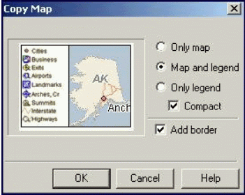
Map copy dialog example
Note, that the user has a choice of copying the map, map and legend, legend only and adding a border.the Copy Map function allows users to paste directly into MSOffice products, Paint, or other graphics program.
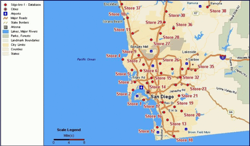
External data from ACT, Excel, Goldmine or Outlook is supported.
(Click for Larger View).This is a map of 38 stores plotted from an Excel
file.BusinessMAP Travel Edition was used to geocode, map, and label the
stores.
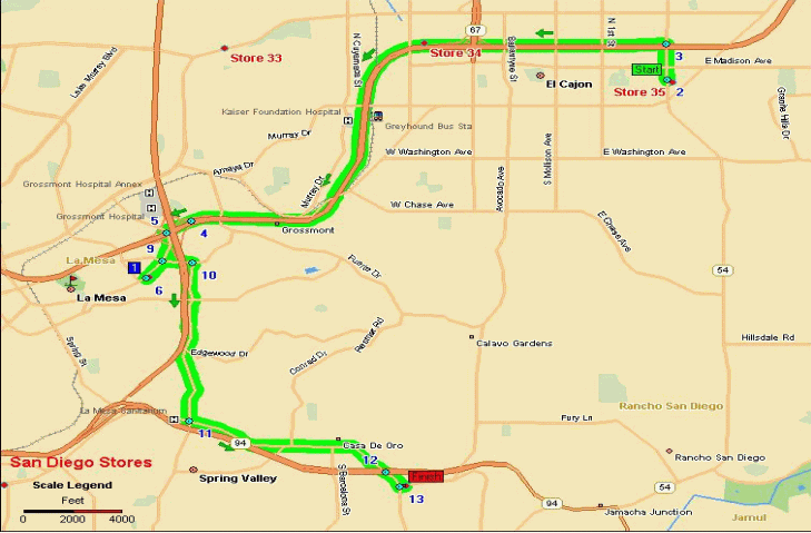
Routing - creating an optimized route.(Click for Larger View) This
is a map showing a route between some of the stores placed on the previous
map. When selecting the stops, the user picks the Start and Finish
first, then can randomly picked the remainder of the stores (not in order).
BusinessMAP Travel Edition created the most direct route (optimized).
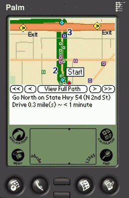
Moving the route, stop and what's nearby information to a Palm device.
The software allows the user to move forward and backward along the route.
Each segment is stored on the Palm device.
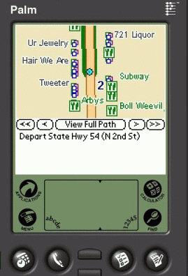
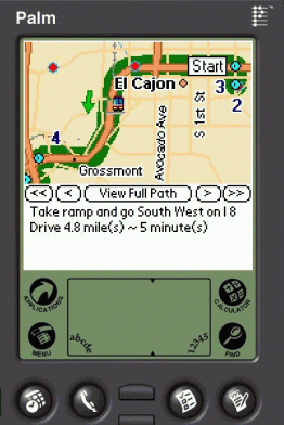
The image on the left shows the beginning of the route and directions.
The image on the right shows what is in the first segment of the route.
Note the businesses are taken from the Dun & Bradstreet database.
What's nearby
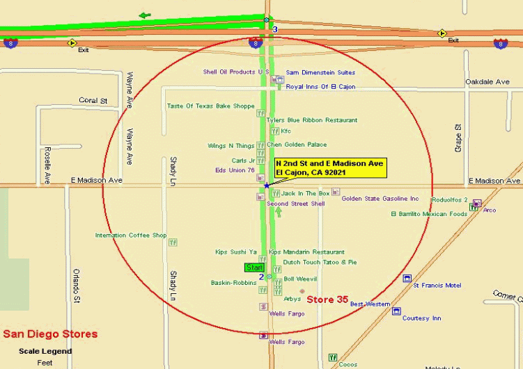
This is a map using the "What's nearby" businesses near the beginning
of our route (Click for Larger View).
Dataview
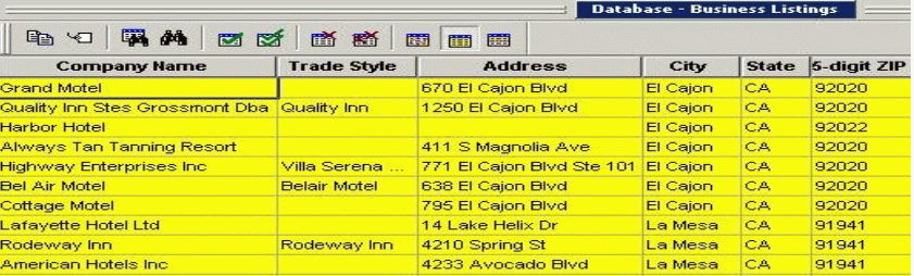
This is a partial view of the data in the Dun & Bradstreet listing
for our "what's nearby" radius.(Click for Larger View)
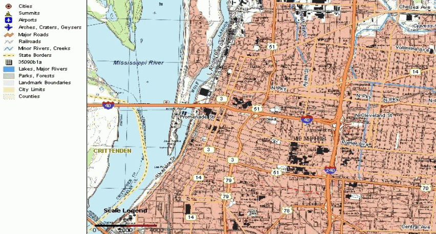
This is map of Memphis with the Maptech topographic maps added as
a layer.(Click for Larger View) This layer loaded automatically from the
web.
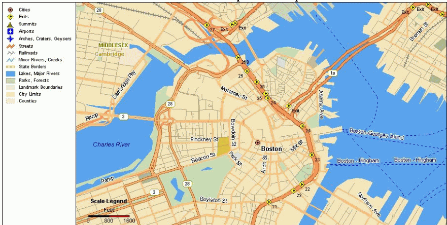
This is Boston one zoom level above where the Maptech aerial photo
is downloaded (Click for Larger View).

Zooming down further, the aerial is loaded automatically - notice
that the streets line up (Click for Larger View).

Imagery - Remember BusinessMAP Travel Edition also supports raster
images (Click for Larger View).This is a map of San Diego with a city
Digital Elevation Model added as a layer.Everything is registered so you
can zoom way down and all the street, highways and other feature remained
lined up.
Conclusion
Now the ultimate personal use of this product would be the road trip.
Plan the route, and get it optimized by the program.Find what is nearby
each stop so you know if your gasoline credit card will work.Then print
it out as a large wall map and also as a series of route segments.Top
it off by putting the whole trip in your Palm device.You might also connect
your GPS receiver to your laptop and watch where you are along your route
you created, in real time.
If you have added the Maptech aerials, get an aerial of each of the gas station or motel stops so you can know exactly where they are relative to the off ramp.
I think you agree that this is a very interesting product for only $79.95. Be sure to visit http://www.esri.com/software/busmap/busmap_travel/index.html