Pitney Bowes MapInfo
One Global View Troy, New York 12180
Tel: 518-285-6000 or 800-FASTMAP
Fax: 518-285-6070
http://www.mapinfo.com
MapInfo Professional version 9.5 is the latest release of Pitney Bowes MapInfo desktop location intelligence software. The list price of the most recent release of MapInfo is $1,645 for a single copy. This review will center on the new features and upcoming enhancements included within a planned maintenance release later this year.
Ease of Use
Pitney Bowes MapInfo continues to enhance the user experience by taking suggestions from the user base to make the software easier to use and produce better maps. The visual elements of MapInfo Professional have been upgraded to appear more consistent with the different Microsoft operating systems. Objects such as dialog boxes appear different in MapInfo Professional, based on the operating system’s current display theme (a Windows control panel setting) for users with Windows 2000, XP or Vista.
MapInfo Professional makes it easier for users to specify feature styles on their maps. The styles for Line Style, Region Style, Symbol Style, Text Style and Colors Style are arranged in a grid denoted with numbers and letters to provide a specific address for a specific style. Figure 1 shows the symbol and color dialogs that appear when a user selects one of the dropdown menus in the Symbol Style dialog box. Users can share specific symbol information with other users, such as the star in Figure 1, by designating its address in the grid, which is E-1. The reference grids can be displayed or hidden by checking the Show reference grid for style pickers on the Options>Preferences>Style dialog.
MapInfo Professional v9.5 supports custom symbols from any raster format that any installed raster handler can support. The Add button on the Symbol Style dialog box allows users to add raster files from their local computers. MapInfo Professional includes a new group of custom symbols from the West London local authorities, called “Civic England.” These new symbols represent institutions, leisure activities and transportation. Users can create their own folders to store custom symbols.
MapInfo Professional can now read the native projection information for shapefiles before creating a .tab file for the shapefile. Upon opening a shapefile, the user will specify a name for the .tab file and MapInfo Professional will read the native projection information of the shapefile. Users have the option to select the projection in the source shapefile or can choose a new projection through a dialog box. Choosing a new projection does not reproject the shapefile’s objects, which could produce unexpected results. This new projection option is useful if the shapefile does not contain the projection information file (.prj), but the user knows the projection of the shapefile from the metadata.
The New Map Window dialog has been redesigned in the latest release of the software. In the past, users could add up to four tables, selections or queries when they created a new map window. The redesigned dialog makes it easier to add more layers when a new map is created. The layer order for the new map can be arranged in the New Map Window dialog box before the map window is created.
Labels in previous versions of MapInfo Professional tended to appear jagged on a map, especially when they were rotated. MapInfo Professional v9.5 includes a new anti-aliasing process to enhance the rendering of labels on a map, so the labels appear smoother on the map display.
MapInfo Professional v9.5 includes a new feature that detects overlapping autolabels and repositions the text around point, line or region in order to avoid overlap and display more labels. The Label options dialog includes radio buttons for adjustments to labels. Examples include “Discard overlapping text,” “When overlaps occur, try another position,” and “Allow overlapping text.” The radio button “When overlaps occur, try another position” is a new option that adjusts the overlapping labels and repositions the text to get as many labels on the map as possible without overlapping with other labels.
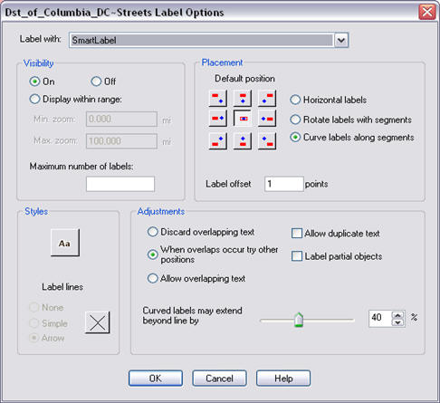
MapInfo Professional v9.0 included the ability to create curved labels. A new feature added to the Label Options dialog in this version sets a percentage of a curved label that extends beyond the size of the polyline if the text for the label is longer than the polyline feature. For example, if the percentage is set to 40%, then the label text can extend up to 40% beyond the end of the polyline for MapInfo Professional to include that curved label on the map. The label will not be displayed on the map if the text is longer than 40% of the size of the polyline. Figure 4 shows the new label adjustment options in MapInfo Professional v9.5, including positioning labels when overlaps occur and the slider bar to extend curved labels.
Another feature that has been added to MapInfo Professional provides a context menu for layer operations such as opening the Layer Control dialog, viewing an entire layer, selecting all objects from a layer, and making a layer editable. The user can press the Select tool on any feature in a layer and then right-click after the selection is made to bring up the context menu. Based on the features selected, the layer name in the Layer Control list will be highlighted in bold letters. The context menu provides a quick way to create selections, access the Layer Control list and maneuver around the map.
Data Creation and Editing
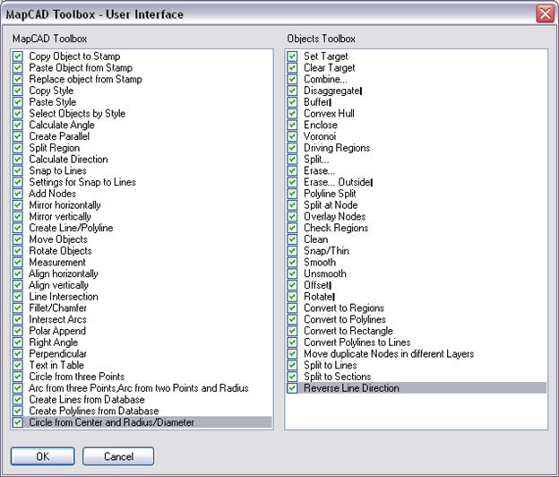
MapInfo Professional includes a new extension called MapCAD, which has a set of powerful CAD drawing tools for enhanced data creation and editing. Pitney Bowes MapInfo has a contractual arrangement with GeoAS to include the MapCAD editing tools in this release of MapInfo Professional. MapCAD is not part of the standard MapInfo Professional installation, meaning that users will have to install this feature separately from the installation CD. Once it is installed and loaded, two new toolbars will appear on the user interface: the MapCAD toolbar and the Objects toolbar. The MapCAD toolbar contains 33 new tools for data editing and the Objects toolbar contains 30 tools. Figure 5 shows the tools available on the MapCAD and Objects toolbars. The MapCAD and Objects toolbars are completely customizable, so that users can check and uncheck the tools from the toolbars to show or hide tools from the toolbars. The Help button on the MapCAD toolbar contains a link to the documentation for the product, including a detailed description of all the MapCAD tools.
Enhanced Data Access
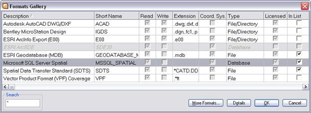
MapInfo Professional continues to support the latest database platforms from vendors such as Microsoft and Oracle. MapInfo Professional has been upgraded to support the Microsoft’s latest release of SQL Server 2008. Adding data from Microsoft SQL Server Spatial is done through the File>Open Universal Data. The first time a user connects to SQL Server 2008, he will have to enter the server and database through the Settings dialog, along with a username and password. The spatial data within Microsoft SQL Server 2008 are Read-Only, whereas the attribute data are Read/Write. Figure 6 shows the Formats Gallery for the Universal Data where the user can choose the Microsoft SQL Server Spatial data option.
MapInfo Professional has updated the list of coordinate system projection codes to include those of Oracle 11g SRID. This function ensures that .tab files based on Oracle tables contain the correct coordinate system reference for MapInfo Professional to display the data correctly in a map window. MapInfo Professional can create a text object from an Oracle 11g table that contains an Annotation Text column. The data from the Annotation Text column can be linked or accessed live.
Another improvement for tables in MapInfo Professional is the ability to drag and drop columns in the Table Maintenance dialog boxes. In previous versions of the software, users had to select a column and then push the Up and Down buttons to move a column to a different location in a table. The Up and Down buttons are still included in the Table Maintenance dialog boxes. However, the ability to simply click on a field and drop it in another location can be very useful to reorder a table that has many columns.
Users who work with a Web Feature Service (WFS) transaction server can use MapInfo Professional to insert, update and delete records from the WFS transaction server. The layer from the WFS can be downloaded locally in MapInfo Professional so that the user can edit the layer. When the user has completed his edits, he can save those edits back to the WFS server. Since several users can be working on single WFS server, MapInfo Professional will check to see if there are any data conflicts for the features that the user edited. If the server cannot commit the changes because of data conflicts, the user can resolve the conflicts automatically, interactively or save the data locally and leave the server as is. The Automatic Conflict Resolution will treat all of the edits the same way and upload them and overwrite the WFS transaction server data. The Interactive Conflict Resolution allows the user to investigate each record in conflict and decide which records to overwrite on the WFS transaction server.
Programmability support via .NET
MapInfo Professional v9.0 became the first release in which MapBasic was included as a free download for the software. MapBasic continues to be a free download with several new functions added in MapInfo Professional v9.5. Developers who want to add GIS functionality or automate a repetitive process in MapInfo Professional can call functions and subroutines written in the MapBasic development environment. MapBasic programs can also call functions and subroutines written using Microsoft's .Net development platform. Developers can write code in languages such as C# (C-sharp) and VB.Net (Visual Basic for .Net), using Microsoft's Visual Studio development environment and then call these procedures with MapBasic. Alternatively, MapInfo Professional can also be integrated inside a .NET application to add location intelligence to a custom application. MapInfo Professional includes a sample program for the “Named Views” tool, which replaces the Named View dialog box with one created in .NET. The .Net Named Views dialog box is resizable and it displays the named views (map bookmarks) in a hierarchical tree, where users can organize their views by dragging and dropping.
Enhanced Licensing and Deployment
MapInfo Professional supports a new deployment option for Workgroup installations. This deployment option allows the storing of application data files, such as templates and custom symbols, in a shared, central location. During the software installation process, there is an option to choose the MapInfo Professional Workgroup Installation. The System Administrators will create both the shared location for the application data files and a method for users to install MapInfo Professional on their local machines. Users will install the application on the computers and create a pointer to the location of the shared files.
MapInfo Professional includes a new licensing model where organizations can distribute permanent licenses using a MapInfo License Server, which is available on the installation CD. Generally, users can activate a permanent node-locked license using the Pitney Bowes MapInfo FNO server, but for users with limited Internet access, a License Server can be installed on an organization’s network to activate a permanent distributed license. Activated Licenses can be transferred to the network License Server or back to Pitney Bowes MapInfo when a user wants to move a license to another computer or needs to make hardware changes such as reformatting a hard disk.
Product Improvement Suggestions
MapInfo Professional includes a new product feedback function through the Help menu for users to submit feedback on the software directly to the product managers.
Planned Enhancements
Pitney Bowes MapInfo is planning a maintenance release for MapInfo Professional v9.5 in November 2008. The maintenance release will include a new enhancement to display translucent vectors and enhanced rendering. Translucent vectors allow a user to place a polygon layer over other layers, yet still be able to see the layers below the polygon layer by setting a translucent fill property for the polygon layer. The selected features fill pattern will have a translucent setting to make the selections look better. Labels will also have a translucent property to lighten the labels and soften the message on the map.
Conclusion
Pitney Bowes MapInfo continues to develop MapInfo Professional to suit customer needs and to support changes in operating system and database software technologies. The product suggestions for the most recent release of MapInfo Professional came directly from a survey of users. The new product feedback function will allow Pitney Bowes MapInfo to collect and analyze user feedback from more of its users going forward. Users should find that the new features in MapInfo Professional v9.5 make the product easier to use and it displays better output. Users who need to edit spatial data will find the MapCAD tools very useful for their workflows and users who access spatial data in Oracle and Microsoft SQL Server database now have updated functionality to access these databases. Developers can now use the .Net integration to customize MapInfo Professional or to add GIS functionality to their applications.
One Global View Troy, New York 12180
Tel: 518-285-6000 or 800-FASTMAP
Fax: 518-285-6070
http://www.mapinfo.com
MapInfo Professional version 9.5 is the latest release of Pitney Bowes MapInfo desktop location intelligence software. The list price of the most recent release of MapInfo is $1,645 for a single copy. This review will center on the new features and upcoming enhancements included within a planned maintenance release later this year.
Ease of Use
Pitney Bowes MapInfo continues to enhance the user experience by taking suggestions from the user base to make the software easier to use and produce better maps. The visual elements of MapInfo Professional have been upgraded to appear more consistent with the different Microsoft operating systems. Objects such as dialog boxes appear different in MapInfo Professional, based on the operating system’s current display theme (a Windows control panel setting) for users with Windows 2000, XP or Vista.
MapInfo Professional makes it easier for users to specify feature styles on their maps. The styles for Line Style, Region Style, Symbol Style, Text Style and Colors Style are arranged in a grid denoted with numbers and letters to provide a specific address for a specific style. Figure 1 shows the symbol and color dialogs that appear when a user selects one of the dropdown menus in the Symbol Style dialog box. Users can share specific symbol information with other users, such as the star in Figure 1, by designating its address in the grid, which is E-1. The reference grids can be displayed or hidden by checking the Show reference grid for style pickers on the Options>Preferences>Style dialog.
 |
MapInfo Professional v9.5 supports custom symbols from any raster format that any installed raster handler can support. The Add button on the Symbol Style dialog box allows users to add raster files from their local computers. MapInfo Professional includes a new group of custom symbols from the West London local authorities, called “Civic England.” These new symbols represent institutions, leisure activities and transportation. Users can create their own folders to store custom symbols.
MapInfo Professional can now read the native projection information for shapefiles before creating a .tab file for the shapefile. Upon opening a shapefile, the user will specify a name for the .tab file and MapInfo Professional will read the native projection information of the shapefile. Users have the option to select the projection in the source shapefile or can choose a new projection through a dialog box. Choosing a new projection does not reproject the shapefile’s objects, which could produce unexpected results. This new projection option is useful if the shapefile does not contain the projection information file (.prj), but the user knows the projection of the shapefile from the metadata.
The New Map Window dialog has been redesigned in the latest release of the software. In the past, users could add up to four tables, selections or queries when they created a new map window. The redesigned dialog makes it easier to add more layers when a new map is created. The layer order for the new map can be arranged in the New Map Window dialog box before the map window is created.
Labels in previous versions of MapInfo Professional tended to appear jagged on a map, especially when they were rotated. MapInfo Professional v9.5 includes a new anti-aliasing process to enhance the rendering of labels on a map, so the labels appear smoother on the map display.
 |
 |
MapInfo Professional v9.5 includes a new feature that detects overlapping autolabels and repositions the text around point, line or region in order to avoid overlap and display more labels. The Label options dialog includes radio buttons for adjustments to labels. Examples include “Discard overlapping text,” “When overlaps occur, try another position,” and “Allow overlapping text.” The radio button “When overlaps occur, try another position” is a new option that adjusts the overlapping labels and repositions the text to get as many labels on the map as possible without overlapping with other labels.
MapInfo Professional v9.0 included the ability to create curved labels. A new feature added to the Label Options dialog in this version sets a percentage of a curved label that extends beyond the size of the polyline if the text for the label is longer than the polyline feature. For example, if the percentage is set to 40%, then the label text can extend up to 40% beyond the end of the polyline for MapInfo Professional to include that curved label on the map. The label will not be displayed on the map if the text is longer than 40% of the size of the polyline. Figure 4 shows the new label adjustment options in MapInfo Professional v9.5, including positioning labels when overlaps occur and the slider bar to extend curved labels.
 |
Another feature that has been added to MapInfo Professional provides a context menu for layer operations such as opening the Layer Control dialog, viewing an entire layer, selecting all objects from a layer, and making a layer editable. The user can press the Select tool on any feature in a layer and then right-click after the selection is made to bring up the context menu. Based on the features selected, the layer name in the Layer Control list will be highlighted in bold letters. The context menu provides a quick way to create selections, access the Layer Control list and maneuver around the map.
Data Creation and Editing
MapInfo Professional includes a new extension called MapCAD, which has a set of powerful CAD drawing tools for enhanced data creation and editing. Pitney Bowes MapInfo has a contractual arrangement with GeoAS to include the MapCAD editing tools in this release of MapInfo Professional. MapCAD is not part of the standard MapInfo Professional installation, meaning that users will have to install this feature separately from the installation CD. Once it is installed and loaded, two new toolbars will appear on the user interface: the MapCAD toolbar and the Objects toolbar. The MapCAD toolbar contains 33 new tools for data editing and the Objects toolbar contains 30 tools. Figure 5 shows the tools available on the MapCAD and Objects toolbars. The MapCAD and Objects toolbars are completely customizable, so that users can check and uncheck the tools from the toolbars to show or hide tools from the toolbars. The Help button on the MapCAD toolbar contains a link to the documentation for the product, including a detailed description of all the MapCAD tools.
 |
Enhanced Data Access
MapInfo Professional continues to support the latest database platforms from vendors such as Microsoft and Oracle. MapInfo Professional has been upgraded to support the Microsoft’s latest release of SQL Server 2008. Adding data from Microsoft SQL Server Spatial is done through the File>Open Universal Data. The first time a user connects to SQL Server 2008, he will have to enter the server and database through the Settings dialog, along with a username and password. The spatial data within Microsoft SQL Server 2008 are Read-Only, whereas the attribute data are Read/Write. Figure 6 shows the Formats Gallery for the Universal Data where the user can choose the Microsoft SQL Server Spatial data option.
 |
MapInfo Professional has updated the list of coordinate system projection codes to include those of Oracle 11g SRID. This function ensures that .tab files based on Oracle tables contain the correct coordinate system reference for MapInfo Professional to display the data correctly in a map window. MapInfo Professional can create a text object from an Oracle 11g table that contains an Annotation Text column. The data from the Annotation Text column can be linked or accessed live.
Another improvement for tables in MapInfo Professional is the ability to drag and drop columns in the Table Maintenance dialog boxes. In previous versions of the software, users had to select a column and then push the Up and Down buttons to move a column to a different location in a table. The Up and Down buttons are still included in the Table Maintenance dialog boxes. However, the ability to simply click on a field and drop it in another location can be very useful to reorder a table that has many columns.
Users who work with a Web Feature Service (WFS) transaction server can use MapInfo Professional to insert, update and delete records from the WFS transaction server. The layer from the WFS can be downloaded locally in MapInfo Professional so that the user can edit the layer. When the user has completed his edits, he can save those edits back to the WFS server. Since several users can be working on single WFS server, MapInfo Professional will check to see if there are any data conflicts for the features that the user edited. If the server cannot commit the changes because of data conflicts, the user can resolve the conflicts automatically, interactively or save the data locally and leave the server as is. The Automatic Conflict Resolution will treat all of the edits the same way and upload them and overwrite the WFS transaction server data. The Interactive Conflict Resolution allows the user to investigate each record in conflict and decide which records to overwrite on the WFS transaction server.
Programmability support via .NET
MapInfo Professional v9.0 became the first release in which MapBasic was included as a free download for the software. MapBasic continues to be a free download with several new functions added in MapInfo Professional v9.5. Developers who want to add GIS functionality or automate a repetitive process in MapInfo Professional can call functions and subroutines written in the MapBasic development environment. MapBasic programs can also call functions and subroutines written using Microsoft's .Net development platform. Developers can write code in languages such as C# (C-sharp) and VB.Net (Visual Basic for .Net), using Microsoft's Visual Studio development environment and then call these procedures with MapBasic. Alternatively, MapInfo Professional can also be integrated inside a .NET application to add location intelligence to a custom application. MapInfo Professional includes a sample program for the “Named Views” tool, which replaces the Named View dialog box with one created in .NET. The .Net Named Views dialog box is resizable and it displays the named views (map bookmarks) in a hierarchical tree, where users can organize their views by dragging and dropping.
Enhanced Licensing and Deployment
MapInfo Professional supports a new deployment option for Workgroup installations. This deployment option allows the storing of application data files, such as templates and custom symbols, in a shared, central location. During the software installation process, there is an option to choose the MapInfo Professional Workgroup Installation. The System Administrators will create both the shared location for the application data files and a method for users to install MapInfo Professional on their local machines. Users will install the application on the computers and create a pointer to the location of the shared files.
MapInfo Professional includes a new licensing model where organizations can distribute permanent licenses using a MapInfo License Server, which is available on the installation CD. Generally, users can activate a permanent node-locked license using the Pitney Bowes MapInfo FNO server, but for users with limited Internet access, a License Server can be installed on an organization’s network to activate a permanent distributed license. Activated Licenses can be transferred to the network License Server or back to Pitney Bowes MapInfo when a user wants to move a license to another computer or needs to make hardware changes such as reformatting a hard disk.
Product Improvement Suggestions
MapInfo Professional includes a new product feedback function through the Help menu for users to submit feedback on the software directly to the product managers.
Planned Enhancements
Pitney Bowes MapInfo is planning a maintenance release for MapInfo Professional v9.5 in November 2008. The maintenance release will include a new enhancement to display translucent vectors and enhanced rendering. Translucent vectors allow a user to place a polygon layer over other layers, yet still be able to see the layers below the polygon layer by setting a translucent fill property for the polygon layer. The selected features fill pattern will have a translucent setting to make the selections look better. Labels will also have a translucent property to lighten the labels and soften the message on the map.
Conclusion
Pitney Bowes MapInfo continues to develop MapInfo Professional to suit customer needs and to support changes in operating system and database software technologies. The product suggestions for the most recent release of MapInfo Professional came directly from a survey of users. The new product feedback function will allow Pitney Bowes MapInfo to collect and analyze user feedback from more of its users going forward. Users should find that the new features in MapInfo Professional v9.5 make the product easier to use and it displays better output. Users who need to edit spatial data will find the MapCAD tools very useful for their workflows and users who access spatial data in Oracle and Microsoft SQL Server database now have updated functionality to access these databases. Developers can now use the .Net integration to customize MapInfo Professional or to add GIS functionality to their applications.
From Our Homepage
Saying Farewell to an Amazing Journey
Communicating with Maps
Is There a GIS Career Ladder?
What does it mean to be geospatially smart? Series
Ways Real Estate and Property Developers Utilize Melissa GeoData for Data-Driven Decisions
Unlocking Value From Daily Satellite Imagery and Insights
Maximizing the Value of Your Address Data with Geo Addressing
How Indoor Mapping Enhances the Security of Smart Buildings
Look Ahead: AI, Location Intelligence and Efficiency
Collaboration Takes on Sea Level Rise & Dynamic Technology Environments
Brownies for Brownfields
Has Everything Been Mapped Already?
How Is Data Literacy Changing in an Artificial Intelligence Landscape
Portfolios for GIS Professionals: More Than Just Maps
How to Create a Distance Matrix in QGIS - A Step-by-Step Guide
7 Ideas for Bringing GIS into the K-12 Classroom
The Geography of Movement