MapPoint 2006
Microsoft Corporation
1 Microsoft Way
Redmond, WA
Product Homepage: http://www.microsoft.com/mappoint/products/2006/default.mspx
Price: $299; $349 with GPS unit
Product Summary
MapPoint 2006 is the next version of Microsoft's desktop mapping software. It is really two separate products: a desktop mapping system and an in-vehicle navigation system. Depending on how you use it, you may see the improvements made from the previous version, MapPoint 2004, as valuable or not. Microsoft touts the vehicle navigation features of this version, and thus potential purchasers should consider whether the desktop mapping features are adequate for the type of analyses required.
For Desktop Mapping
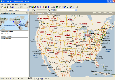
Users of MapPoint 2004 or previous versions of MapPoint will find that not much has changed with the interface or menu items (see Figure 1). In fact, very few features have been added at all. I expected to see more map manipulation features. I found none. The thematic mapping, territory wizard, drive time zone creation and annotation tools were the same as in MapPoint 2004…not even any new point placement icons or drawing options were added.
Data
The demographic data are vintage 2004, which is unfortunate since 2005 data files are available from Applied Geographic Solutions, Microsoft's supplier of demographics. Moreover, 2006 data will be available soon. Even the Help File that should point to information about where to find additional data sources has a link to a page with information about MapPoint 2004 only. There are more choices of consumer-oriented data included with this version (e.g. purchasing preferences, personal financial patterns, household expenditures for specific goods, etc.) than in MapPoint 2004 which will allow users to drill deeper into the psychographic profile of a specific geography.
Converting from an old database
I keep a sales database in MapPoint. I built most of the contacts using MapPoint 2004; some were added manually while others were imported from Microsoft Outlook or from an Excel spreadsheet. Converting to 2006 was somewhat disappointing. Many contacts did not convert correctly from the .ptm file. To explore the problem further, I exported the converted data to an Excel spreadsheet. Some addresses had the wrong country associated with them while some names were placed with the wrong company. It appears as if the conversion process misinterpreted some column headings. This did not happen to all of the data contained in the .ptm file but only for some of the databases that I had originally imported into MapPoint 2004 and later converted to MapPoint 2006.
New Features
"Locate Me": One standard feature of MapPoint 2006 caters to the mobile professional. The "Locate Me" function looks for Wi-Fi access points in the area and tries to discern your location without the use of a global positioning system (GPS). If you did not purchase MapPoint with the GPS option, this is a helpful feature. It does not allow navigation but establishes a frame of reference.
Analysis Functionality
I am disappointed with the data manipulation capabilities. I thought that MapPoint 2004 did a great job of providing the function whereby data variables can be divided by each other to create a unique spatial index map. There was also an option to create drive times. So, why not add a few more spatial analysis tools like Theissen polygon creation or a way to create multiple drive time polygons in a single pass? It would also have been helpful to be able to limit the extent of a thematic map instead of always having to create a map for the entire country. This option would thus reduce the time for map creation.
For Vehicle Navigation
I tested the navigation features of MapPoint 2006 during a short local drive and also a longer drive from Indianapolis, Indiana to Huntsville, Alabama along Interstate 65, mostly at night. In addition to having MapPoint running on my IBM Thinkpad T21, I also used a Garmin i5 in-vehicle navigation system for comparison. To start, the SiRFstarIII GPS unit that is bundled with MapPoint 2006 was quick to pick up satellites and I was ready to navigate in under one minute. Although the route I was following for the longer drive was mostly on interstates, there were several decision points along the way. I programmed both MapPoint and the Garmin unit to navigate to my home address.
Position and Size of Map Display
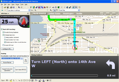
MapPoint 2006 divides its display for navigation into three panes: GPS, Map and Driving Guidance. The GPS Pane contains the options for route calculation and control of the map display; the Map Pane contains the map and route; the Driving Guidance Pane contains the text directions. I did not configure the laptop for voice directions.
The display on my laptop is about 14 inches and the directions are clearly visible (see Figure 2) in the Driving Guidance Pane. There is really no comparison with the Garmin since its display is only 2.5 inches and looks roughly the size of a baseball. Surprisingly however, that is not a drawback of the Garmin i5 – the map display is bright and clear. However, with MapPoint, positioning the laptop for the driver is difficult. Where my Garmin unit was attached to the windshield with a suction cup just under my rearview mirror, my laptop had to remain on the passenger seat. While the Garmin unit is more in a line of site to the roadway, a laptop-based navigation system like MapPoint is almost always relegated to a position away from the driver's field of view and they would be forced to look away from the road. However, MapPoint 2006 does include voice commands which would help to mitigate this drawback.
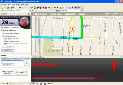
Route recalculation, that is redefining the route should the driver miss a turn, is an absolute necessity for vehicle navigation. MapPoint 2006 offers recalculation via a "Go" button in the GPS Task Pane or hitting F3 (Function Key #3). The software does not do this automatically, which I found annoying. Only an "Off Route" message (Figure 3) is displayed to let the driver know he has taken a wrong turn. The driver must take his hands off the wheel to manually instruct the software to recalculate the route, which is both difficult and potentially dangerous.
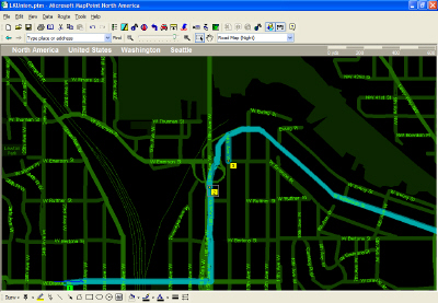
The nighttime option or "low light level" map display is a nice touch and provides a clear visual for dark conditions (Figure 4). However, this display option must be configured manually. The Garmin i5, by comparison, interprets the time of day and automatically changes to a night visual. MapPoint 2006 has the ability to keep the map oriented in the direction of travel and to keep the vehicle location in the center of the display at all times, another nice touch.
Accuracy and Geographic Data
The MapPoint maps are phenomenally accurate. I was amazed at one point when we crossed a county boundary, marked by a roadside sign, and the MapPoint display had the vehicle positioned perfectly. (Perhaps I should have been more surprised that the sign was in the right place!) The MapPoint 2006 website promotes the fact that the geographic data for this version has been updated. I, like so many others, always look to see if my street is on the map. I live on a relatively new street in a neighborhood that is only about two years old. Online map portals, Rand McNally specifically, had been properly locating my street on its online services for about 12 months. However, MapPoint 2006 does not include my street and strangely enough, excludes a railroad track spur nearby that had been included in MapPoint 2004.
Points of Interest
Any good in-vehicle navigation system will have key points of interest (POI). MapPoint has an abundance of options and the ability to navigate from POIs instead of just an address is done well.
My Take
What were they thinking? Was this product an afterthought? Did Microsoft all of a sudden realize it had not planned for the next version of MapPoint and had to get a release out the door anyway with minimal improvement? Was the fact that the MapPoint group, now part of Microsoft's mobility division, was more focused on the navigation features and not the desktop mapping features? If so, had the product team looked at the competition in the aftermarket for in-vehicle navigation systems like Garmin and TomTom?
Somewhere along the way, I think Microsoft lost its focus in desktop mapping. It is trying to be two products when there are clearly better options for either desktop mapping or vehicle navigation. Perhaps, those that have developed plug-ins or have linked MapPoint with MapPoint Web Services will find this product satisfies their needs. It did not satisfy mine for what I want to do either at my desk or on the road.


