I previously reviewed two versions of Terrain Navigator
Pro, the 6.3
and 7.01
versions. Maptech has released a
7.5 version and the most recent upgrade, version 8.0, which will be the
topic of this software review. Terrain Navigator Pro is a software
program that provides access to U.S. Geological Survey (USGS)
topographic quadrangle maps and USGS Digital Ortho Quarter Quads
(DOQQs). The software allows the user seamless access to the
topographic maps and DOQQs across the state or region purchased. The
newest version of the product offers new data enhancements, additional
modules that can be purchased separately, and new functions to
incorporate data from Google Earth.
New High Resolution Color Imagery
Terrain Navigator Pro customers have one year of unlimited access to aerial photo coverage for all areas where they have topographic map coverage. Aerial photos from Maptech are served through the company's server and an Internet connection is required to access them. Users can download the images from the Maptech server to their local computers. Terrain Navigator Pro lets users check for updated topographic maps and aerial photos via the Internet and download any new versions available. The black and white aerial photos in previous versions of Terrain Navigator Pro have been upgraded to color aerial photos. The current version of Terrain Navigator Pro includes new one-meter color aerial photographs from the USGS for most of the U.S. The new color aerial photos can be viewed at a scale of 1:12,000, similar to the scale of the black and white aerial photos; scales as large as 1:3,600 are available in some areas. The Map Scale dropdown list will show the scale of aerial photos that are available for an area.
Google Earth
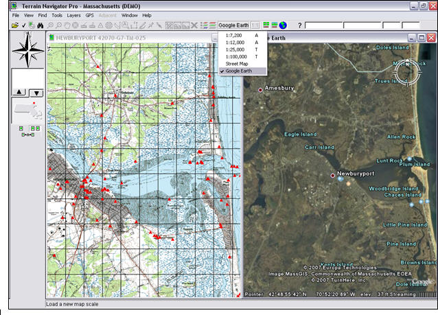
Terrain Navigator Pro now includes direct access to data through Google Earth. The user will need to have Google Earth installed on his computer and an Internet connection to access the Google Earth data within Terrain Navigator Pro. Google Earth can be downloaded free of charge. After Google Earth is installed, the user can access Google Earth data in Terrain Navigator Pro by selecting "Google Earth" from the Map Scale dropdown list. Figure 1 shows the Terrain Navigator Pro in split-screen mode with a USGS topographic quadrangle map in the left window and the Google Earth imagery in the right window.
A user cannot use Terrain Navigator Pro's tools in the Google Earth window. The Google Earth navigation tools, such as zoom in and out, are used to manipulate the Google Earth map. The maps in split-screen mode can be synched by pressing the "Globe" button on the right of the Map Scale dropdown list. A user can add layers from Terrain Navigator Pro's maps to view them on the Google Earth image. All layers (markers, routes and tracks) must be created on Terrain Navigator Pro maps and photos before they can be viewed on Google Earth imagery. The user can control the appearance of the Google Earth layers by opening the Google Earth application separately and checking the boxes for the layers he wishes to display.
U.S. Streets Module
The U.S. Streets module is an optional module that can be purchased separately to view street data within Terrain Navigator Pro 8.0. This module contains primary and secondary street layers from Tele Atlas for the entire U.S. The U.S. Streets module enables Terrain Navigator Pro to generate detailed text and graphic driving directions. The U.S. Streets module is displayed on the map using the Map Scale dropdown list similar to the Google Earth option. The streets can be overlaid on the Terrain Navigator Pro topographic quadrangles or imagery, or can be viewed as a standalone map window. Figure 2 shows the U.S. Streets module in one window and the streets overlaid as a layer on a USGS topographic quadrangle.
The U.S. Streets module can also produce Driving Directions within
Terrain Navigator Pro. Driving Distance Preferences can be set using
the File>Preferences menu. The user can specify two
addresses
through the Tools>Driving Directions menu. After the
addresses are
entered, Terrain Navigator Pro will create a track for the route and
produce a dialog box with the driving directions. Figure 3 shows the
Driving Distance dialog box along with the track shown on a color image
and on the street map. Driving Directions can also be created using two
or more waypoints on the map using the Route tool. After entering the
waypoints on the map, right-click and choose "Create Track on
Streets"
from the popup menu to show the route along the street network and the
driving directions between the waypoints.
Additional Enhancements
The Coordinate Preferences has been updated to adjust the coordinate readings, bearings, time and elevation preferences. The Township/Range coordinate system has been added to the Coordinate Preferences and the township and range grids can be viewed as an overlay on the map. The Coordinate Preferences also allows the user to specify a primary and alternative coordinate system so that the user can view the map coordinates in two different coordinate systems at the same time.
Terrain Navigator Pro now includes an Undo option in the Tools menu that will undo the last action performed. The Undo function can be used to delete the last change made to any dynamic layer (such as markers, routes, tracks and labels) directly on a map. The Undo function can also be used to undo any changes made in an edit window. The Undo function only remembers the last action performed, so the user cannot go back and undo several actions. File management operations such as Save, Copy Maps to Hard Drive, Import or Export cannot be undone.
The remote technical support option for Terrain Navigator Pro 8.0 is a new feature of the software. This function allows a Maptech Customer Support representative to temporarily have remote access to a user's computer in order to provide a more accurate diagnosis of any problems that the user might be experiencing. Remote access is set up via a small download from Maptech's website to the local computer.
Lastly, I'd like to touch on a few of the enhancements to Terrain Navigator Pro version 7.5, since I did not review that version of the software. The 7.5 version was the first version to be compatible with the Windows Vista operating system. Terrain Navigator Pro's GeoTip feature, which lets the user hover the cursor over a track to get specialized details, includes options for Leg Average Speed and Total Average Speed. The Coordinate Preferences includes an option to select the unit of measurement for bearing readings. Tracks can also be renamed or broken up before they are imported into Terrain Navigator Pro.
Conclusion
The latest upgrade to Maptech's Terrain Navigator Pro software provides users with access to the most up-to-date data through Maptech's servers and new product functionality and is compatible with Windows XP and Vista. The major addition to the product is the ability to access Google Earth maps within Terrain Navigator Pro. Users can compare the new color imagery from the USGS DOQQ's with the imagery available via by Google Earth. Users who wish to see additional detail on their maps should consider purchasing the U.S. Streets module to add street layer information to the topographic maps and DOQQ's.
New High Resolution Color Imagery
Terrain Navigator Pro customers have one year of unlimited access to aerial photo coverage for all areas where they have topographic map coverage. Aerial photos from Maptech are served through the company's server and an Internet connection is required to access them. Users can download the images from the Maptech server to their local computers. Terrain Navigator Pro lets users check for updated topographic maps and aerial photos via the Internet and download any new versions available. The black and white aerial photos in previous versions of Terrain Navigator Pro have been upgraded to color aerial photos. The current version of Terrain Navigator Pro includes new one-meter color aerial photographs from the USGS for most of the U.S. The new color aerial photos can be viewed at a scale of 1:12,000, similar to the scale of the black and white aerial photos; scales as large as 1:3,600 are available in some areas. The Map Scale dropdown list will show the scale of aerial photos that are available for an area.
Google Earth
Terrain Navigator Pro now includes direct access to data through Google Earth. The user will need to have Google Earth installed on his computer and an Internet connection to access the Google Earth data within Terrain Navigator Pro. Google Earth can be downloaded free of charge. After Google Earth is installed, the user can access Google Earth data in Terrain Navigator Pro by selecting "Google Earth" from the Map Scale dropdown list. Figure 1 shows the Terrain Navigator Pro in split-screen mode with a USGS topographic quadrangle map in the left window and the Google Earth imagery in the right window.
A user cannot use Terrain Navigator Pro's tools in the Google Earth window. The Google Earth navigation tools, such as zoom in and out, are used to manipulate the Google Earth map. The maps in split-screen mode can be synched by pressing the "Globe" button on the right of the Map Scale dropdown list. A user can add layers from Terrain Navigator Pro's maps to view them on the Google Earth image. All layers (markers, routes and tracks) must be created on Terrain Navigator Pro maps and photos before they can be viewed on Google Earth imagery. The user can control the appearance of the Google Earth layers by opening the Google Earth application separately and checking the boxes for the layers he wishes to display.
 |
The U.S. Streets module is an optional module that can be purchased separately to view street data within Terrain Navigator Pro 8.0. This module contains primary and secondary street layers from Tele Atlas for the entire U.S. The U.S. Streets module enables Terrain Navigator Pro to generate detailed text and graphic driving directions. The U.S. Streets module is displayed on the map using the Map Scale dropdown list similar to the Google Earth option. The streets can be overlaid on the Terrain Navigator Pro topographic quadrangles or imagery, or can be viewed as a standalone map window. Figure 2 shows the U.S. Streets module in one window and the streets overlaid as a layer on a USGS topographic quadrangle.
 |
 |
Additional Enhancements
The Coordinate Preferences has been updated to adjust the coordinate readings, bearings, time and elevation preferences. The Township/Range coordinate system has been added to the Coordinate Preferences and the township and range grids can be viewed as an overlay on the map. The Coordinate Preferences also allows the user to specify a primary and alternative coordinate system so that the user can view the map coordinates in two different coordinate systems at the same time.
Terrain Navigator Pro now includes an Undo option in the Tools menu that will undo the last action performed. The Undo function can be used to delete the last change made to any dynamic layer (such as markers, routes, tracks and labels) directly on a map. The Undo function can also be used to undo any changes made in an edit window. The Undo function only remembers the last action performed, so the user cannot go back and undo several actions. File management operations such as Save, Copy Maps to Hard Drive, Import or Export cannot be undone.
The remote technical support option for Terrain Navigator Pro 8.0 is a new feature of the software. This function allows a Maptech Customer Support representative to temporarily have remote access to a user's computer in order to provide a more accurate diagnosis of any problems that the user might be experiencing. Remote access is set up via a small download from Maptech's website to the local computer.
Lastly, I'd like to touch on a few of the enhancements to Terrain Navigator Pro version 7.5, since I did not review that version of the software. The 7.5 version was the first version to be compatible with the Windows Vista operating system. Terrain Navigator Pro's GeoTip feature, which lets the user hover the cursor over a track to get specialized details, includes options for Leg Average Speed and Total Average Speed. The Coordinate Preferences includes an option to select the unit of measurement for bearing readings. Tracks can also be renamed or broken up before they are imported into Terrain Navigator Pro.
Conclusion
The latest upgrade to Maptech's Terrain Navigator Pro software provides users with access to the most up-to-date data through Maptech's servers and new product functionality and is compatible with Windows XP and Vista. The major addition to the product is the ability to access Google Earth maps within Terrain Navigator Pro. Users can compare the new color imagery from the USGS DOQQ's with the imagery available via by Google Earth. Users who wish to see additional detail on their maps should consider purchasing the U.S. Streets module to add street layer information to the topographic maps and DOQQ's.
From Our Homepage
Saying Farewell to an Amazing Journey
Communicating with Maps
Is There a GIS Career Ladder?
What does it mean to be geospatially smart? Series
Ways Real Estate and Property Developers Utilize Melissa GeoData for Data-Driven Decisions
Unlocking Value From Daily Satellite Imagery and Insights
Maximizing the Value of Your Address Data with Geo Addressing
How Indoor Mapping Enhances the Security of Smart Buildings
Look Ahead: AI, Location Intelligence and Efficiency
Collaboration Takes on Sea Level Rise & Dynamic Technology Environments
Brownies for Brownfields
Has Everything Been Mapped Already?
How Is Data Literacy Changing in an Artificial Intelligence Landscape
Portfolios for GIS Professionals: More Than Just Maps
How to Create a Distance Matrix in QGIS - A Step-by-Step Guide
7 Ideas for Bringing GIS into the K-12 Classroom
The Geography of Movement