Protecting the public from environmental
dangers is a time-consuming and expensive endeavor.The Environmental Protection Agency (EPA)
now has a powerful tool to effectively manage data on hazardous waste
sites.The EPA's Knowledge Management Application (EPAKMA) will cut
costs and streamline the information collected in response to the
Comprehensive
Environmental Response, Compensation, and Liability Act (CERCLA),
commonly referred to as the Superfund program.
Enacted in December 1980, the Superfund program taxes chemical and petroleum industries.The collected funds are used for the clean-up of uncontrolled or abandoned hazardous waste sites.If no person or party is found liable for the hazardous waste identified, money from the Superfund program is allocated for the clean-up of the site.
The EPA is required to follow a standard set of procedures under the Superfund program to determine whether a site contains contaminants that are at a high enough concentration to warrant action by the agency.If contaminants are suspected at a site, the EPA is required to follow a remediation process to determine appropriate action.
The Superfund program and its requirements have resulted in the generation of a large amount of data that is frequently referred to and used during the site evaluation process.The data is stored in three different locations:
The EPA hired GeoDecisions to assist the EPA Knowledge Management Team in the development of the prototype EPAKMA for the Region 4 Federal Facilities Branch.The EPAKMA was designed to allow EPA section chiefs and regional project managers to track the data being collected more efficiently.It also allowed them to track subsequent remediation reports created during the Superfund site mitigation program at the U.S.Department of Energy's Savanna River Site.
The first objective in developing the EPAKMA focused on converting the FFACTR from tracking site-level documents and their completion status into a spatially-enabled format.This format allowed the GeoDecisions team to develop a Web-deployed interface to display data points in a mapping interface along with contextual data layers.
With this enhancement, section chiefs can identify documents related to an environmental sub-site or operable unit, such as individual ponds, soil sampling locations, and buildings, and determine its status and review its progress.
The client-side application is license free, leveraging the Scaleable Vector Graphic (SVG) Viewer and Java scripting.The sub-site locations and their attributes, along with the contextual data layers, are stored within the client-side code through the use of an ESRI translation tool.Sub-site documentation status attributes are stores in Extensible Markup Language (XML).
The use of XML and an SVG Viewer makes EPAKMA an unusual application. Very few applications are able to use this particular combination of cutting-edge technology successfully on such a large-scale project while meeting the XML standards of the federal government and the EPA. "There is a large difference between data management and knowledge management," stated Richard Hammond, EPA Knowledge Management Team Manager."The EPAKMA tool provides true knowledge management capabilities.Importantly, because it uses XML as its base, the work that we do can be easily transferred and customized for other groups that find it valuable."
While this conversion of the FFACTR provided a new and much more powerful tool to review macro-level progress within many sub-sites, the next step in the application development required a micro-level approval to site documentation interaction.Currently, regional project managers and site managers compile a multitude of complex documentation describing the investigation, remediation planning and remediation activities of a sub-site.These reports are housed in a main database called the Electronic Records Document Management System (ERDMS).XML allows EPAKMA users to click on a sub-site and retrieve an electronic version of the reports in either Microsoft Word or PDF format.This functionality translates into significant time and cost savings for the EPA.
Future enhancements to the application will leverage XML-tagged reports so that data points from these multiple sources can be analyzed quickly.It will also allow users to generate a concise, synthesized report from specific fields.These reports will allow regional project managers or section chiefs to determine the level of effort needed to complete the remediation of a proposed area by using only the information collected up until that point in time.Using the application, users can determine the number of full-time equivalent staffers needed for each site management plan. Full-time equivalents are units used by the federal government in assessing the workload of a particular project and are based on a 2,080 person-hour year.
All of these developments allow the EPA to effectively manage data with a user-friendly application.The EPAKMA is a single, Web-based tool that allows users to leverage data from individual sampling locations to existing reports with a macro-level progress view.The simple data interaction tools and customized interface allow users to teach themselves the application without the need for rigorous classroom training.It also enhances the user's understanding of data as they relate to a project's overall objectives by offering global views of the process.As a result, the EPA Knowledge Management Team can better use the information gathered for the Superfund program.With enhanced decision-support tools, the EPA Region 4 Knowledge Management Application provides spatially-enabled information as a cost-effective solution for handling regional hazardous waste site concerns.
Enacted in December 1980, the Superfund program taxes chemical and petroleum industries.The collected funds are used for the clean-up of uncontrolled or abandoned hazardous waste sites.If no person or party is found liable for the hazardous waste identified, money from the Superfund program is allocated for the clean-up of the site.
The EPA is required to follow a standard set of procedures under the Superfund program to determine whether a site contains contaminants that are at a high enough concentration to warrant action by the agency.If contaminants are suspected at a site, the EPA is required to follow a remediation process to determine appropriate action.
The Superfund program and its requirements have resulted in the generation of a large amount of data that is frequently referred to and used during the site evaluation process.The data is stored in three different locations:
- the Comprehensive Environmental Response, Compensation, and Liability Information System (CERCLIS) database, a database that contains all data collected on a particular site;
- the Federal Facilities Agreement Commitment Tracking Report (FFACTR), a bi-monthly report that provides the current status of documents under review for a particular region; and
- annual site management plans,
non-standard reports that are
generated by regional project managers to illustrate progress at a
specific site.
The EPA hired GeoDecisions to assist the EPA Knowledge Management Team in the development of the prototype EPAKMA for the Region 4 Federal Facilities Branch.The EPAKMA was designed to allow EPA section chiefs and regional project managers to track the data being collected more efficiently.It also allowed them to track subsequent remediation reports created during the Superfund site mitigation program at the U.S.Department of Energy's Savanna River Site.
The first objective in developing the EPAKMA focused on converting the FFACTR from tracking site-level documents and their completion status into a spatially-enabled format.This format allowed the GeoDecisions team to develop a Web-deployed interface to display data points in a mapping interface along with contextual data layers.
With this enhancement, section chiefs can identify documents related to an environmental sub-site or operable unit, such as individual ponds, soil sampling locations, and buildings, and determine its status and review its progress.
The client-side application is license free, leveraging the Scaleable Vector Graphic (SVG) Viewer and Java scripting.The sub-site locations and their attributes, along with the contextual data layers, are stored within the client-side code through the use of an ESRI translation tool.Sub-site documentation status attributes are stores in Extensible Markup Language (XML).
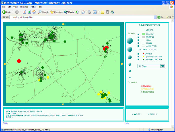 |
| The
resulting interface provides simple tools for navigating a site and
allows users to visualize report schedule compliance.Source:
GeoDecisions.Click image for larger view. |
The use of XML and an SVG Viewer makes EPAKMA an unusual application. Very few applications are able to use this particular combination of cutting-edge technology successfully on such a large-scale project while meeting the XML standards of the federal government and the EPA. "There is a large difference between data management and knowledge management," stated Richard Hammond, EPA Knowledge Management Team Manager."The EPAKMA tool provides true knowledge management capabilities.Importantly, because it uses XML as its base, the work that we do can be easily transferred and customized for other groups that find it valuable."
While this conversion of the FFACTR provided a new and much more powerful tool to review macro-level progress within many sub-sites, the next step in the application development required a micro-level approval to site documentation interaction.Currently, regional project managers and site managers compile a multitude of complex documentation describing the investigation, remediation planning and remediation activities of a sub-site.These reports are housed in a main database called the Electronic Records Document Management System (ERDMS).XML allows EPAKMA users to click on a sub-site and retrieve an electronic version of the reports in either Microsoft Word or PDF format.This functionality translates into significant time and cost savings for the EPA.
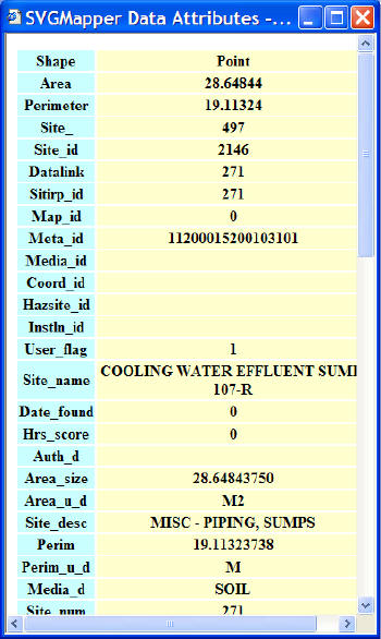 |
| Users click on a
document symbol,
display general information pertaining to that document, and in the
future will be able to open the report in question directly through
their browser.
Source:
GeoDecisions. Click image for larger view. |
Future enhancements to the application will leverage XML-tagged reports so that data points from these multiple sources can be analyzed quickly.It will also allow users to generate a concise, synthesized report from specific fields.These reports will allow regional project managers or section chiefs to determine the level of effort needed to complete the remediation of a proposed area by using only the information collected up until that point in time.Using the application, users can determine the number of full-time equivalent staffers needed for each site management plan. Full-time equivalents are units used by the federal government in assessing the workload of a particular project and are based on a 2,080 person-hour year.
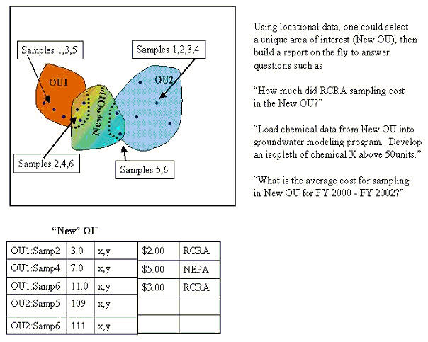 |
| Synthesized
reports generated by site
investigators using existing data provide enhanced pre-planning and
result in potential cost savings. Source:
GeoDecisions. Click image for larger view. |
All of these developments allow the EPA to effectively manage data with a user-friendly application.The EPAKMA is a single, Web-based tool that allows users to leverage data from individual sampling locations to existing reports with a macro-level progress view.The simple data interaction tools and customized interface allow users to teach themselves the application without the need for rigorous classroom training.It also enhances the user's understanding of data as they relate to a project's overall objectives by offering global views of the process.As a result, the EPA Knowledge Management Team can better use the information gathered for the Superfund program.With enhanced decision-support tools, the EPA Region 4 Knowledge Management Application provides spatially-enabled information as a cost-effective solution for handling regional hazardous waste site concerns.
From Our Homepage
Saying Farewell to an Amazing Journey
Communicating with Maps
Is There a GIS Career Ladder?
What does it mean to be geospatially smart? Series
Ways Real Estate and Property Developers Utilize Melissa GeoData for Data-Driven Decisions
Unlocking Value From Daily Satellite Imagery and Insights
Maximizing the Value of Your Address Data with Geo Addressing
How Indoor Mapping Enhances the Security of Smart Buildings
Look Ahead: AI, Location Intelligence and Efficiency
Collaboration Takes on Sea Level Rise & Dynamic Technology Environments
Brownies for Brownfields
Has Everything Been Mapped Already?
How Is Data Literacy Changing in an Artificial Intelligence Landscape
Portfolios for GIS Professionals: More Than Just Maps
How to Create a Distance Matrix in QGIS - A Step-by-Step Guide
7 Ideas for Bringing GIS into the K-12 Classroom
The Geography of Movement