A pavement network is important to any community.
Investing in a
pavement management system (PMS) can pay for itself many times over
through reduced repair costs, optimized maintenance schedules and
interagency coordination (e.g.making sure that newly paved roads are
not immediately torn up for sewer or cable maintenance).But for a PMS
to make the maximum impact and yield the highest return on investment,
it must be easily accessible and understandable to all users, including
maintenance crews and departmental staff in planning, public works,
transportation and finance.
Sonoma County's Department of Transportation and Public Works and Farallon Geographics of San Francisco implemented an Enterprise GIS asset tracking system to help monitor and maintain the County's pavement network system.The new GIS-PMS allows County management to use a Web-based map interface to identify problem pavement areas in near real-time.
Sonoma County is located to the north of San Francisco.Sonoma County's Public Work's department is responsible for maintaining 1,387 miles of the County's 1,857 roads, a network of pavement regularly traveled by hundreds of thousands of vehicles.
County engineers were already using a PMS application called StreetSaver, developed and sold by the Bay Area's Metropolitan Transportation Commission (MTC). Engineers collect and enter information about specific stretches of roads (e.g.pavement condition, available maintenance treatments and costs and the history of the road network) into a StreetSaver form. Using the relevant data, StreetSaver can perform budget analysis, including projecting costs of network maintenance and rehabilitation as well as creating budget alternatives.These budget analyses are used to allocate pavement maintenance budgets.
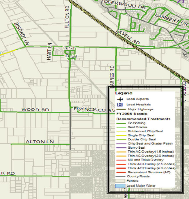
StreetSaver's analysis and output capabilities are limited to tabular datasets and reports.County engineers recognized that presenting the results of their pavement management analyses using maps would be a more compelling and information-rich way to visualize StreetSaver's data and results.This would allow both managers and technicians to see where they might gain maintenance efficiencies.StreetSaver and the County's ESRI ArcGIS were not linked.Further, each system contained different types of data.To display road condition information, County managers printed out hard copy maps from the GIS and then manually highlighted problem areas that were identified based on StreetSaver database printouts.
MTC and the County recognized that dynamically integrating the County's ArcGIS system and StreetSaver would make it possible to generate integrated maps that could show both detailed street maps and pavement condition and maintenance information.The Sonoma/Farallon GIS-PMS does just that using dynamic segmention of the street data into pavement sections. This insures that visual displays are always in sync with the tabular data.The linkage also makes real-time scenario and maintenance analysis possible."We immediately recognized the usefulness of the maps.Because our mapping system is interactive, we can use maps to show managers and funding agencies our street maintenance responsibility," said Mark Wein, Civil Engineer with Sonoma County's Department of Transportation and Public Works.
The team used ESRI's ArcSDE geodatabase technology and Microsoft's SQL Server database to design a GIS data model that would support integrated, real-time access to StreetSaver's pavement information.To get the network GIS model to interact with PMS data required building dynamic segmentation procedures using tools in ArcGIS.The team used the StreetSaver database post mile data at the time the user requests the information to partition the streets into paving sections in real-time.The tabular and map datasets always remain in sync and the GIS maps can accurately highlight just the portions of a roadway that require maintenance.
The dynamic segmentation capability allows edits to be made to the StreetSaver data directly from the GIS by clicking on a segment and changing attributes specific to the road network segment.Pavement managers can immediately see the results of such data changes on a map. Using the integrated GIS and PMS, County staff can quickly map StreetSaver information into the GIS and perform spatial analysis, allowing them to quickly create maps showing the extent of distressed streets "We already had spent the time and research to develop a route-based system," said Tom Nguyen, Senior Engineering Program Analyst with Sonoma County's Department of Transportation and Public Works."Public Works staff could now use the GIS-PMS to quickly create and present maps showing the extent of distressed pavement, and the location and number of lanes and average daily traffic volume throughout the County."
The team also developed and deployed an internally accessible Web site to ensure that County managers could immediately to see the latest pavement distress maps and budgeting scenarios.The ArcIMS Web application allows Planning, Public Works and Finance personnel to interact with StreetSaver tabular data linked with dynamically segmented GIS maps.This site allows management personnel, who are not GIS experts, to quickly identify and understand problem pavement areas.
The GIS-PMS produces strong visual evidence of street pavement conditions throughout the County.It should ultimately reduce the number of complaints from residents as well as allowing Public Works to prioritize work and funding."Because the maps are interactive, we can use them to show funding agencies our street maintenance responsibility," said Wein.
The GIS-PMS also
serves as a sophisticated asset management system.Traditional asset
management
systems are not suited to handle geographically based assets, which
have been
managed alphabetically or in arbitrary groups.But assets such as
pavement
networks and utilities are best managed by a system that relates assets
through
maps.
A further benefit of using a GIS-based PMS is that it allows easier compliance with the new accounting rules that require government entities to present a set of financial statements with a "net asset" focus.Long-term fixed assets such as pavement assets were previously expensed and not capitalized on their balance sheets.The GIS-PMS allows the County to not be required to depreciate pavement assets.Depreciation is required if proper maintenance activity cannot be demonstrated.
Sonoma County's Department of Transportation and Public Works and Farallon Geographics of San Francisco implemented an Enterprise GIS asset tracking system to help monitor and maintain the County's pavement network system.The new GIS-PMS allows County management to use a Web-based map interface to identify problem pavement areas in near real-time.
Sonoma County is located to the north of San Francisco.Sonoma County's Public Work's department is responsible for maintaining 1,387 miles of the County's 1,857 roads, a network of pavement regularly traveled by hundreds of thousands of vehicles.
County engineers were already using a PMS application called StreetSaver, developed and sold by the Bay Area's Metropolitan Transportation Commission (MTC). Engineers collect and enter information about specific stretches of roads (e.g.pavement condition, available maintenance treatments and costs and the history of the road network) into a StreetSaver form. Using the relevant data, StreetSaver can perform budget analysis, including projecting costs of network maintenance and rehabilitation as well as creating budget alternatives.These budget analyses are used to allocate pavement maintenance budgets.
StreetSaver's analysis and output capabilities are limited to tabular datasets and reports.County engineers recognized that presenting the results of their pavement management analyses using maps would be a more compelling and information-rich way to visualize StreetSaver's data and results.This would allow both managers and technicians to see where they might gain maintenance efficiencies.StreetSaver and the County's ESRI ArcGIS were not linked.Further, each system contained different types of data.To display road condition information, County managers printed out hard copy maps from the GIS and then manually highlighted problem areas that were identified based on StreetSaver database printouts.
MTC and the County recognized that dynamically integrating the County's ArcGIS system and StreetSaver would make it possible to generate integrated maps that could show both detailed street maps and pavement condition and maintenance information.The Sonoma/Farallon GIS-PMS does just that using dynamic segmention of the street data into pavement sections. This insures that visual displays are always in sync with the tabular data.The linkage also makes real-time scenario and maintenance analysis possible."We immediately recognized the usefulness of the maps.Because our mapping system is interactive, we can use maps to show managers and funding agencies our street maintenance responsibility," said Mark Wein, Civil Engineer with Sonoma County's Department of Transportation and Public Works.
The team used ESRI's ArcSDE geodatabase technology and Microsoft's SQL Server database to design a GIS data model that would support integrated, real-time access to StreetSaver's pavement information.To get the network GIS model to interact with PMS data required building dynamic segmentation procedures using tools in ArcGIS.The team used the StreetSaver database post mile data at the time the user requests the information to partition the streets into paving sections in real-time.The tabular and map datasets always remain in sync and the GIS maps can accurately highlight just the portions of a roadway that require maintenance.
The dynamic segmentation capability allows edits to be made to the StreetSaver data directly from the GIS by clicking on a segment and changing attributes specific to the road network segment.Pavement managers can immediately see the results of such data changes on a map. Using the integrated GIS and PMS, County staff can quickly map StreetSaver information into the GIS and perform spatial analysis, allowing them to quickly create maps showing the extent of distressed streets "We already had spent the time and research to develop a route-based system," said Tom Nguyen, Senior Engineering Program Analyst with Sonoma County's Department of Transportation and Public Works."Public Works staff could now use the GIS-PMS to quickly create and present maps showing the extent of distressed pavement, and the location and number of lanes and average daily traffic volume throughout the County."
The team also developed and deployed an internally accessible Web site to ensure that County managers could immediately to see the latest pavement distress maps and budgeting scenarios.The ArcIMS Web application allows Planning, Public Works and Finance personnel to interact with StreetSaver tabular data linked with dynamically segmented GIS maps.This site allows management personnel, who are not GIS experts, to quickly identify and understand problem pavement areas.
 |
The GIS-PMS produces strong visual evidence of street pavement conditions throughout the County.It should ultimately reduce the number of complaints from residents as well as allowing Public Works to prioritize work and funding."Because the maps are interactive, we can use them to show funding agencies our street maintenance responsibility," said Wein.
 |
A further benefit of using a GIS-based PMS is that it allows easier compliance with the new accounting rules that require government entities to present a set of financial statements with a "net asset" focus.Long-term fixed assets such as pavement assets were previously expensed and not capitalized on their balance sheets.The GIS-PMS allows the County to not be required to depreciate pavement assets.Depreciation is required if proper maintenance activity cannot be demonstrated.
From Our Homepage
Saying Farewell to an Amazing Journey
Communicating with Maps
Is There a GIS Career Ladder?
What does it mean to be geospatially smart? Series
Ways Real Estate and Property Developers Utilize Melissa GeoData for Data-Driven Decisions
Unlocking Value From Daily Satellite Imagery and Insights
Maximizing the Value of Your Address Data with Geo Addressing
How Indoor Mapping Enhances the Security of Smart Buildings
Look Ahead: AI, Location Intelligence and Efficiency
Collaboration Takes on Sea Level Rise & Dynamic Technology Environments
Brownies for Brownfields
Has Everything Been Mapped Already?
How Is Data Literacy Changing in an Artificial Intelligence Landscape
Portfolios for GIS Professionals: More Than Just Maps
How to Create a Distance Matrix in QGIS - A Step-by-Step Guide
7 Ideas for Bringing GIS into the K-12 Classroom
The Geography of Movement