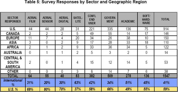
The report stemmed from attempted contacts with 10,000 people, resulting in 1,547 on-line surveys, 250 personal interviews, several focus groups and insights from 15 industry luminaries. The surveys included responses from these eight sectors: Aerial Film, Aerial Digital, Aerial Sensor, Satellite, Software/Hardware, Commercial End User, Government, Academia.
 |
 |
- Most respondents want improvements to existing technologies, rather than new technologies.
- African respondents want improved Airborne GPS.
- South American respondents want greater ground resolution for aerial and satellite imagery.
- U.S. local, state and federal governments want technology integration and better ground resolution.
All participants were asked to identify economic, political and environmental trends that will drive their need for these data for two time frames: 2010 and 2015.
2010
- National Defense/Homeland Security
- Endangered Species and Natural Resources/Heritage Protection
- Required Cadastral Mapping
- Remote Sensing becoming a commodity
- Global Warming
- Licensing Issues
- International Trade
- Open Skies Initiative
- Expansion of the EU
- Outsourcing/Privatization
- National Defense/Homeland Security
- Global Warming
- Endangered Species and Natural Resources/Heritage Protection
- Licensing Issues
- Required Cadastral Mapping
- Remote Sensing becoming a Commodity
- International Trade
- Open Skies Initiative
- Expansion of the EU
- Outsourcing/Privatization
Anonymous comments from those interviewed regarding the political, economic and environmental trends follow.
"The trend toward outsourcing project work off-shore will continue due to lower wage rates in developing countries. While the processing may be transferred overseas, the flight crews and ground control teams will continue to be local. Processing can be done in any location, so larger shops (today) will become significantly smaller, and their functions will shift from production to quality control."Future Technologies
"There will be a continued drive for better data and higher levels of cooperation with the government and private sectors. Resources, especially with Homeland Security, need to be pulled together."
"As Global Warming continues there will be an increase in melting ice caps and rising oceans, so more money will be needed for radar and marine systems and additional monitoring. As all of this is continuing, the technology will be getting better, become more mechanized with less human interaction needed.”
"Remote sensing will need to become a part of daily life. It will be difficult to make money selling imagery back to the government. It will need to be integrated into society for the greatest profits and the greatest competition. It is like the PC's. They did not take off until they became a part of one's daily life. The focus on National Security is going to speed up this acceptance curve."
The respondents identified three areas of future development: micro-satellites, hyperspectral and advanced imaging technologies, and on-line mapping services.
Micro-satellites
Micro-satellites provided several opportunities for remote sensing due to the following factors:
- Shorter development times
- Less expensive to build
- Less expensive to launch
- Less power consumption
- Lower cost justifies specific short-term use
- Provides technologies for less developed countries.
Hyperspectral and Advanced Imaging Technologies
Hyperspectral imagery extends the spectrum and allows for coverage that can be better influenced by such technologies as wave front sensors and adaptive optics (removal of atmospheric distortion).
One of the examples given in the report was Kestrel Corporation, using a combination of micro-satellites and hyperspectral imagery, fast 2D capture and 1 meter resolution. Another example of hyperspectral imagery from space was in a paper given by Dr. John Schummers of the Air Force Research Laboratory.
Online Mapping Services
Both Google and Microsoft's Virtual Earth were identified as providing key new technologies that may contribute to making remote sensing technology a commodity.
Revenue
While the actual market size was not specifically addressed, there was a consensus on the nature of the satellite suppliers. Respondents felt that the overall number of satellite vendors would shrink and the number of those considered "large"- $10M in revenue, will grow. There are currently seven vendors in the "large" category and that number was projected to grow to 11 vendors by 2015.
 |
The most important aspect of the report is the discussion of the nature of future technologies. For example, small, cheap, easy lift micro-satellites can provide access to this technology to a much broader base of users and vendors. The micro-satellite market probably parallels the growth of UAV (unmanned aerial vehicle) technology and the use of very small UAVs. The political, economic and environmental issues are very volatile in today's world and what seems like a key issue today can quickly be eclipsed by another tomorrow. The survey respondents have identified major issues that will influence remote sensing, but in today's world, 2015 is too far away to really plan or predict effectively. It will be interesting to look back on this document in both 2010 and 2015 and see what the remote sensing market actually looks like at that time.
Alliance Partners
Partners in providing insight to this project are shown in the table below.
| American Surveyor | US and International |
| Association of American Geographers | US and International |
| BAE Systems | US and International |
| Corbley Communications | US and International |
| Directions Magazine | US and International |
| Earth Imaging Journal Magazine | US and International |
| Eurimage | Europe, Asia, Africa Australia |
| GITA | US and International |
| GITC America | US |
| Geo Community
International |
US and International |
| GeoSearch | US |
| GeoVantage | US |
| GeoWorld Magazine/GeoPlace.com |
US and International |
| GSDI Association | Africa |
| ICTAF at Tel-Aviv University | Europe |
| Intelligence Data Systems | US |
| MAPPS | US |
| MDA Geospatial Services (Radarsat) | Canada and US |
| Orbimage | US and International |
| PCI Geometrics | US and Canada |
| Position Magazine | Asia, Australia & Pacific Rim |
| Spatial Resources | US |
| Spectrum Mapping | US and International |
| URISA | US and Canada |
| Woolpert | US |
| Z/I Imaging - Intergraph | US and International |
From Our Homepage
Saying Farewell to an Amazing Journey
Communicating with Maps
Is There a GIS Career Ladder?
What does it mean to be geospatially smart? Series
Ways Real Estate and Property Developers Utilize Melissa GeoData for Data-Driven Decisions
Unlocking Value From Daily Satellite Imagery and Insights
Maximizing the Value of Your Address Data with Geo Addressing
How Indoor Mapping Enhances the Security of Smart Buildings
Look Ahead: AI, Location Intelligence and Efficiency
Collaboration Takes on Sea Level Rise & Dynamic Technology Environments
Brownies for Brownfields
Has Everything Been Mapped Already?
How Is Data Literacy Changing in an Artificial Intelligence Landscape
Portfolios for GIS Professionals: More Than Just Maps
How to Create a Distance Matrix in QGIS - A Step-by-Step Guide
7 Ideas for Bringing GIS into the K-12 Classroom
The Geography of Movement