OpenStreetMap (OSM)
is a
project in which a community of volunteers generates a free world map,
which has, in some cities, turned out to be more detailed than
commercial or government data. Until now the world of "volunteered
geography" (Goodchild)
collaborative projects and the world of
geographic information (GI) standards used by the GI market and defined
by the Open Geospatial Consortium (OGC) were still somewhat separate. OpenRouteService.org is trying
to
bring these two worlds together. It is the first routing service that
uses OSM data and provides those through the standardized interfaces
specified by the OGC within the OGC Open Location Services initiative
(OpenLS).
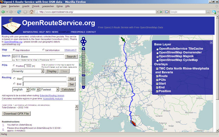
OpenRouteService now supports routing from Denmark to Italy. Germany, Switzerland, Austria, Italy, Denmark and Liechtenstein are currently supported by the OpenLS Routing Service and OpenLS Directory Service (POI Search), the OGC WMS and WFS used by OpenRouteService.org. The version for the United Kingdom/Great Britain will go live soon; the coverage will be further extended.
Routing services are probably the most important application for street data. While there are some applications that can provide routing with OSM data, I focus here on an approach based on the concept of interoperable Web services and open standards. OpenRouteService is much more than a routing service; it uses a wide range of OGC services based on OSM data that also could be used in other applications and scenarios.
Currently the following OGC services have been implemented within the frame of OpenRouteService.org based on OSM data:
OpenRouteService.org currently offers an end-user oriented website with an interactive map. First prototypes of mobile clients are available, but we plan to also make the services available as OGC Web services that can be used through http-based xml-requests as specified in the OGC OpenLS specification. This will allow developers to use these services in an open and interoperable way easily within their own applications.
All mentioned OpenLS services and WPS processes have been implemented by the Research Group Cartography, Department of Geography, University of Bonn.
OpenRouteService now supports routing from Denmark to Italy. Germany, Switzerland, Austria, Italy, Denmark and Liechtenstein are currently supported by the OpenLS Routing Service and OpenLS Directory Service (POI Search), the OGC WMS and WFS used by OpenRouteService.org. The version for the United Kingdom/Great Britain will go live soon; the coverage will be further extended.
 |
Routing services are probably the most important application for street data. While there are some applications that can provide routing with OSM data, I focus here on an approach based on the concept of interoperable Web services and open standards. OpenRouteService is much more than a routing service; it uses a wide range of OGC services based on OSM data that also could be used in other applications and scenarios.
Currently the following OGC services have been implemented within the frame of OpenRouteService.org based on OSM data:
- The OpenLS Directory Service is a service that provides access to an online directory (e.g., Yellow Pages) to find the location of a specific, or the nearest, place, product or service.
- The OpenLS Location Utility Service provides a Geocoder/Reverse Geocoder; the Geocoder transforms a description of a location, such as a place name, street address or postal code, into a normalized description of the location with a Point geometry.
- The OpenLS Presentation (Map Portrayal) Service portrays a map comprised of a base map derived from any geospatial data and a set of Abstract Data Types as overlays.
- cars: fastest
- cars: shortest
- cars: for fastest and shortest additional option: no highway
- cars: use real-time traffic (TMC), for Northrhine-Westphalia and Bavaria
- bicycles
- pedestrian
- further extensions (particular options for different types of bicycles, etc.) are planned or in process
- RDS-TMC data on traffic jams, construction work or accidents are visualized as a WMS layer and taken into account when routing. Currently, we support only the test areas of Bavaria and Northrhine-Westphalia. The TMC data have been integrated through a service chain consisting of the following:
- OGC SOS (Sensor Observation Service),
- OGC WPS (Web Processing Service), and
- OGC WFS-T (Web Feature Service- transactional)
- Accessibility Analysis Service (AAS) – The AAS calculates a polygon representing the area that is reachable within a certain time distance based on a street network around a given location.
- An OGC WMS (Web Map Service) with SLD support provides an alternative to the usual OSM renderer (such as Mapnik/OSMRenderer) for visualizing the OSM data of the selected countries.
- Internally, we use an OGC WFS (Web Feature Service). Within it, the OpenStreetMap data have been structured thematically in semantic layers - in contrast to the simple OSM data model. This means that the OpenStreetMap data can be accessed through GML and used in further SDI or GIS applications.
- The relevant metadata will be inserted into an OGC CS-W (Catalogue Service Web).
- An OGC WPS (Web Processing Service) for calculating height profiles of the calculated routes has been realized based on SRTM DEM data and will be integrated into the website soon.
OpenRouteService.org currently offers an end-user oriented website with an interactive map. First prototypes of mobile clients are available, but we plan to also make the services available as OGC Web services that can be used through http-based xml-requests as specified in the OGC OpenLS specification. This will allow developers to use these services in an open and interoperable way easily within their own applications.
All mentioned OpenLS services and WPS processes have been implemented by the Research Group Cartography, Department of Geography, University of Bonn.
From Our Homepage
Saying Farewell to an Amazing Journey
Communicating with Maps
Is There a GIS Career Ladder?
What does it mean to be geospatially smart? Series
Ways Real Estate and Property Developers Utilize Melissa GeoData for Data-Driven Decisions
Unlocking Value From Daily Satellite Imagery and Insights
Maximizing the Value of Your Address Data with Geo Addressing
How Indoor Mapping Enhances the Security of Smart Buildings
Look Ahead: AI, Location Intelligence and Efficiency
Collaboration Takes on Sea Level Rise & Dynamic Technology Environments
Brownies for Brownfields
Has Everything Been Mapped Already?
How Is Data Literacy Changing in an Artificial Intelligence Landscape
Portfolios for GIS Professionals: More Than Just Maps
How to Create a Distance Matrix in QGIS - A Step-by-Step Guide
7 Ideas for Bringing GIS into the K-12 Classroom
The Geography of Movement