SAP has offered geospatial solutions in collaboration
with ESRI for a number of years. SAP management believes, however, that
the fundamentals of the market have changed. According to Oliver
Mainka, SAP's GIS program manager, the company has taken the last 18
months to reevaluate the solutions that it brings to its substantial
existing customer base. This self-analysis comes at a time when SAP's
main competitor, Oracle, has an established clientele, a mature
technology, and an appetite for purchasing companies in market segments
designed to displace SAP. In the fiercely competitive arena of
enterprise applications, such as customer relationship management (CRM)
and enterprise resource planning (ERP) and the systems integration
services that may accompany them, SAP and Oracle have nearly equal
market share with approximately 20% each (Source: AMR Research).
Market Discoveries
SAP's GIS program task force, code named "Sagres" for the Portuguese town and site of the 15th century navigation school started by Prince Henry the Navigator, conducted a careful review of its clients to identify the GIS market potential. The Sagres team realized that not many within SAP knew about GIS because its customers rarely asked about it. However, through an internal review of customers responding to a survey, the team discovered that 250 user organizations had reviewed or completed a SAP/GIS integration project. To explore further, SAP set about observing customer workflows using a series of interviews in each client's workplace environment. Results indicated that 95% of those who were using geospatial technology were employing code created by the customer using application programming interfaces (APIs) to integrate GIS solutions, such as those from ESRI or Smallworld. The Sagres team also found that customers feared losing track of data assets because of a lack of integration with other enterprise systems.
The Sagres team also ascertained that the functionality most often used by customers was fairly basic: map visualization, geocoding, proximity search and simple location-based services such as routing. The team learned that 80% of its customers wanted to integrate GIS around an Enterprise Asset Management (EAM) application. SAP collected the data and created use cases to determine where the company could support these applications and where functionality needed to be developed. It was then up to the team to design an architectural framework and build a prototype that it could take to management with the hope of bringing a solution to market.
Prototype Architecture
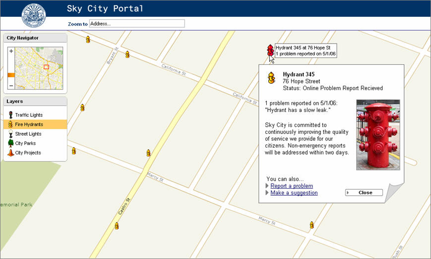
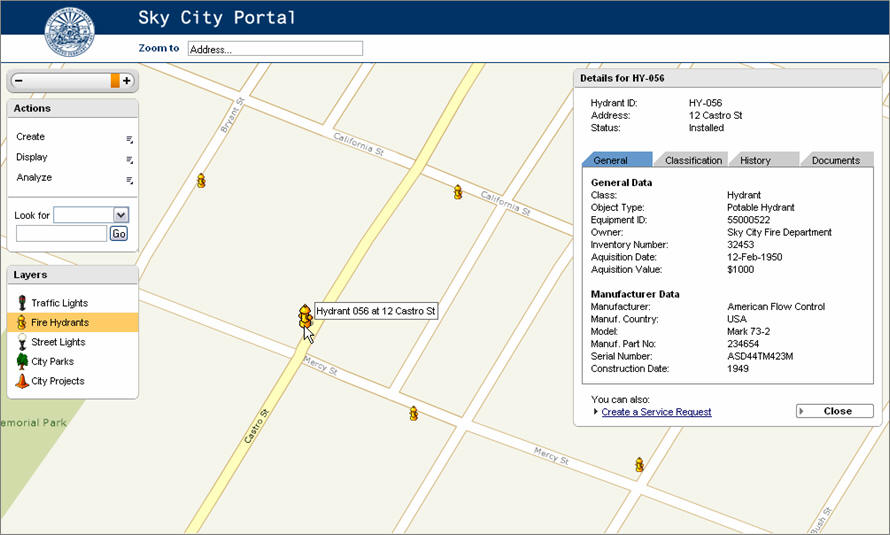
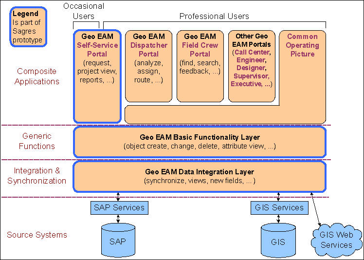
With its strength in EAM, SAP understood that it had a robust local government clientele. Its market research also revealed that many local entities were using some form of Web portal to display basic city services, but almost none offered a way for citizens to communicate with city officials about problems in their area. The Sagres prototype, called Geospatial Enterprise Asset Management, or Geo EAM, offers applications that a typical local government might want to deploy, in both a customer facing and a professional or employee mode. Citizens are treated to a Web-based interface for communicating power outages or street repairs (figure 1 illustrates a simple city asset finder), while city employees use an intranet for finding and updating work orders (figure 2 illustrates a more detailed view of asset information presented in figure 1). Functionally, SAP wants to integrate enterprise applications already in use by its customers with geospatial technology (figure 3). In the prototype, SAP NetWeaver was used as the platform to integrate geospatial services and then provide an application layer to expose the functionality to users (figure 4).
Observations
Most of the applications proposed by SAP's Sagres team are those that you would expect, following a thorough market review of its customer base. These applications are neither new, nor unusual. It has taken SAP a while, however, to understand the potential within its customer base when its competition had already engaged the market with some forms of geoprocessing. However, SAP does not appear to have lost much ground in tapping into its substantial list of clients, even though its research found limited understanding and deployment of geospatial applications. As one of the largest independent software vendors (ISV) in the world, SAP stands to benefit substantially by simply educating its existing sales force, something that Oracle has yet to fully appreciate. So, with SAP now making an aggressive charge into the geospatial market and with Oracle well entrenched in many applications, it only leaves Microsoft to fully enjoin the fray among the top ISV's. Geospatial technology is now an important competitive lever in the battle for enterprise system dominance, a fact that is not lost on the larger systems integrators.For example, Directions Magazine recently reported on the creation of a geospatial technology division at CH2M HILL.
Booz Allen Hamilton has for the last few years focused on the homeland security market, and Accenture is addressing the market for insurance applications. (Look for an article on that soon.) These observations create a broader picture of a maturing geospatial technology market. As individual GIS software solution providers change their business models from pure software sales to solution integration services, they begin to impact the ISV market previously dominated by SAP, Oracle, IBM and others. And with the recent entry by systems integrators, the clash among these three groups is just beginning and the result could be a frenzy of activity leading to mergers and acquisitions.
Market Discoveries
SAP's GIS program task force, code named "Sagres" for the Portuguese town and site of the 15th century navigation school started by Prince Henry the Navigator, conducted a careful review of its clients to identify the GIS market potential. The Sagres team realized that not many within SAP knew about GIS because its customers rarely asked about it. However, through an internal review of customers responding to a survey, the team discovered that 250 user organizations had reviewed or completed a SAP/GIS integration project. To explore further, SAP set about observing customer workflows using a series of interviews in each client's workplace environment. Results indicated that 95% of those who were using geospatial technology were employing code created by the customer using application programming interfaces (APIs) to integrate GIS solutions, such as those from ESRI or Smallworld. The Sagres team also found that customers feared losing track of data assets because of a lack of integration with other enterprise systems.
The Sagres team also ascertained that the functionality most often used by customers was fairly basic: map visualization, geocoding, proximity search and simple location-based services such as routing. The team learned that 80% of its customers wanted to integrate GIS around an Enterprise Asset Management (EAM) application. SAP collected the data and created use cases to determine where the company could support these applications and where functionality needed to be developed. It was then up to the team to design an architectural framework and build a prototype that it could take to management with the hope of bringing a solution to market.
Prototype Architecture
With its strength in EAM, SAP understood that it had a robust local government clientele. Its market research also revealed that many local entities were using some form of Web portal to display basic city services, but almost none offered a way for citizens to communicate with city officials about problems in their area. The Sagres prototype, called Geospatial Enterprise Asset Management, or Geo EAM, offers applications that a typical local government might want to deploy, in both a customer facing and a professional or employee mode. Citizens are treated to a Web-based interface for communicating power outages or street repairs (figure 1 illustrates a simple city asset finder), while city employees use an intranet for finding and updating work orders (figure 2 illustrates a more detailed view of asset information presented in figure 1). Functionally, SAP wants to integrate enterprise applications already in use by its customers with geospatial technology (figure 3). In the prototype, SAP NetWeaver was used as the platform to integrate geospatial services and then provide an application layer to expose the functionality to users (figure 4).
 |
 |
 |
 |
Observations
Most of the applications proposed by SAP's Sagres team are those that you would expect, following a thorough market review of its customer base. These applications are neither new, nor unusual. It has taken SAP a while, however, to understand the potential within its customer base when its competition had already engaged the market with some forms of geoprocessing. However, SAP does not appear to have lost much ground in tapping into its substantial list of clients, even though its research found limited understanding and deployment of geospatial applications. As one of the largest independent software vendors (ISV) in the world, SAP stands to benefit substantially by simply educating its existing sales force, something that Oracle has yet to fully appreciate. So, with SAP now making an aggressive charge into the geospatial market and with Oracle well entrenched in many applications, it only leaves Microsoft to fully enjoin the fray among the top ISV's. Geospatial technology is now an important competitive lever in the battle for enterprise system dominance, a fact that is not lost on the larger systems integrators.For example, Directions Magazine recently reported on the creation of a geospatial technology division at CH2M HILL.
Booz Allen Hamilton has for the last few years focused on the homeland security market, and Accenture is addressing the market for insurance applications. (Look for an article on that soon.) These observations create a broader picture of a maturing geospatial technology market. As individual GIS software solution providers change their business models from pure software sales to solution integration services, they begin to impact the ISV market previously dominated by SAP, Oracle, IBM and others. And with the recent entry by systems integrators, the clash among these three groups is just beginning and the result could be a frenzy of activity leading to mergers and acquisitions.
From Our Homepage
Saying Farewell to an Amazing Journey
Communicating with Maps
Is There a GIS Career Ladder?
What does it mean to be geospatially smart? Series
Ways Real Estate and Property Developers Utilize Melissa GeoData for Data-Driven Decisions
Unlocking Value From Daily Satellite Imagery and Insights
Maximizing the Value of Your Address Data with Geo Addressing
How Indoor Mapping Enhances the Security of Smart Buildings
Look Ahead: AI, Location Intelligence and Efficiency
Collaboration Takes on Sea Level Rise & Dynamic Technology Environments
Brownies for Brownfields
Has Everything Been Mapped Already?
How Is Data Literacy Changing in an Artificial Intelligence Landscape
Portfolios for GIS Professionals: More Than Just Maps
How to Create a Distance Matrix in QGIS - A Step-by-Step Guide
7 Ideas for Bringing GIS into the K-12 Classroom
The Geography of Movement