eWhen geospatial information is hosted remotely at many
different locations, the goal of having one access point to share,
disseminate and visualize these data poses a challenge. This challenge
becomes even greater when the data are spread across eight countries,
which speak multiple languages and have limited infrastructure, and
they need to be accessed by a variety of end-users, ranging from the
general public, to government officials, to tech-savvy Ph.D.s. The
answer to this challenge quickly became SERVIR.
SERVIR is the Regional Visualization and Monitoring System ("servir"
means “to serve" in Spanish) for Mesoamerica, a region extending from
southern Mexico to Panama, including Belize, Costa Rica, El Salvador,
Guatemala, Honduras and Nicaragua. As part of the SERVIR effort, the
Institute for the Application of Geospatial Technology (IAGT) developed SERVIR Viz, a free,
easy-to-use data access and visualization framework for distributing
remote sensing imagery, GIS data, region-specific thematic maps and
other scientific data products.
Background: The SERVIR Project
The SERVIR project strives to expand the use of Earth science observations and predictive modeling capabilities for managing the important resources of Mesoamerica, and to disseminate this usable information to decision makers. SERVIR intensively utilizes satellite imagery and other data sources for environmental management, natural disaster monitoring and mitigation support in the region. SERVIR is supported by NASA, the Water Center for the Humid Tropics of Latin America and the Caribbean (CATHALAC), the United States Agency for International Development (USAID), the World Bank, the Environmental Ministries of the Mesoamerican Countries, the University of Alabama at Huntsville, IAGT and other partners.
IAGT's primary role in SERVIR is to provide enhanced mapping and 3D visualization capabilities. This improved capacity assists decision makers in better understanding and addressing the dynamic environmental and ecological issues in Mesoamerica. IAGT has worked with, and developed, many 3D visualization applications and tools to serve a wide variety of purposes and end-users. Based on this experience, IAGT was able to fast track development of SERVIR Viz, in support of the SERVIR project and its partners.
SERVIR Viz
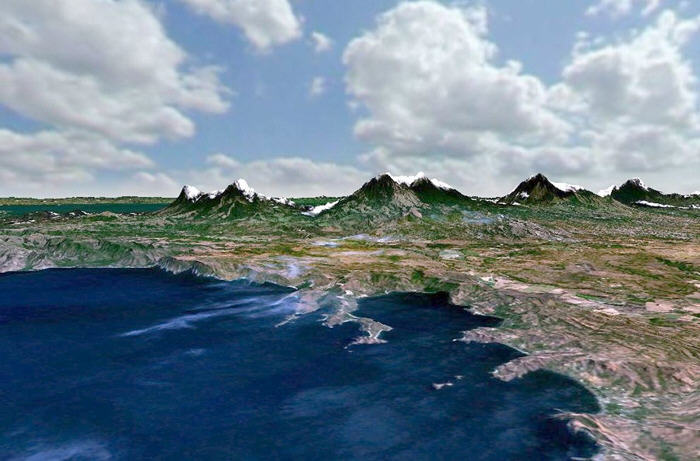
SERVIR Viz (download) is a customized version of NASA's free, open-source, Web-enabled, 3D Earth exploration tool known as World Wind. SERVIR Viz allows users to employ custom tools and view, share and access remotely-hosted data layers, maps, near real-time satellite images and other SERVIR products in an interactive, 3D globe environment.
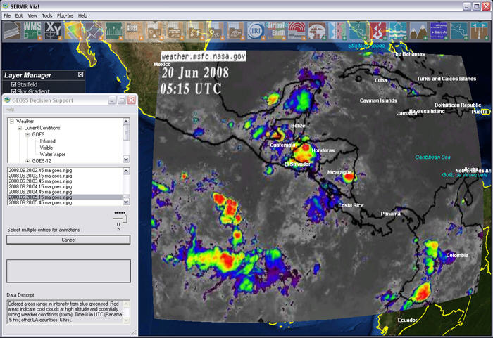
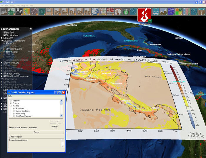
SERVIR Viz enhances the SERVIR project infrastructure by providing access to Global Earth Observation System of Systems (GEOSS) data products and other Internet-served GIS data products. GEOSS data are organized by topic and include themed areas such as weather, ocean, climate, disaster and ecology. The purpose of GEOSS is to achieve comprehensive, coordinated and sustained observations of the Earth system in order to improve monitoring of the state of the Earth and to increase understanding of Earth processes.
GEOSS data within SERVIR Viz can be made transparent, animated in a
time series and overlaid on top of each other. By overlaying multiple
datasets and changing layer transparency, data products can be used
together to monitor complex interactions. A key example of such is the
prediction of landslide events. This can be achieved by overlaying
accumulated and forecasted precipitation data over locations with
heavily sloped terrain, in order to identify areas with a high
probability for landslides. Applications like these provide timely
information to local decision makers during critical events.
Much of the Internet-served data within SERVIR Viz consist of information provided by SERVIR partner countries. The partner countries have made data available to the public using Web Map Services (WMS), an open standard for publishing GIS datasets. SERVIR Viz connects to and displays these data, overlaid on global satellite or other imagery natively available in World Wind. In addition, SERVIR Viz can be toggled between English and Spanish to support a wide cross-section of users.
SERVIR Viz Development
SERVIR Viz is fully interoperable with NASA World Wind, and can be used in conjunction with the numerous plug-ins and add-ons available through World Wind support websites. The add-ons and plug-ins extend the functionality of the application and are often created by the open-source community of users and developers.
IAGT has developed a number of custom add-ons and plug-ins for SERVIR Viz to meet specific project needs. The WMS and GEOSS features are examples of useful and widely used plug-ins for SERVIR Viz. Add-ons for SERVIR Viz consist mainly of additional datasets. Many of the add-ons make a connection to Internet-based data sources and are automatically updated each time the user opens SERVIR Viz. Some of the dynamic, add-on data available include the latest fire, earthquake, weather and flood information for the region.
SERVIR Viz in Action
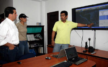
The environmental and disaster management communities in Mesoamerica have embraced SERVIR Viz. NASA, USAID and the World Bank have supported further development and awareness of SERVIR Viz by providing training workshops, conference presentations and funding for custom enhancements.
The value of SERVIR Viz was demonstrated most notably in November 2006. The president of Panama, Martin Torrijos, visited the CATHALAC facility in Panama during a heavy rainfall event in which more than 40 inches of rain fell in a short period of time. SERVIR Viz was used as a briefing tool to forecast and assess potential flooding in the region. As a result of the briefing, the president issued an advisory to the Bocas del Toro and Veraguas regions of Panama. Landslides in those areas were later detected, proving the life-saving and disaster mitigation utility of SERVIR and SERVIR Viz.
Presentations and Awards
SERVIR Viz was selected as a winner in the 5th International Digital Earth Grand Challenge 3D Visualization Contest. A panel of international judges selected SERVIR Viz from a global pool of entries, underscoring IAGT's position as an innovative and leading provider of geospatially enabled visualization technology solutions. IAGT was recognized for this achievement at an awards ceremony during the 5th International Symposium on Digital Earth (ISDE5) at the University of California at Berkeley in June 2007.
SERVIR Viz was also presented at the Group on Earth Observations (GEO) Ministerial Summit in Capetown, South Africa, and at the United Nations Framework Convention on Climate Change (UNFCCC) in Bali, Indonesia, both in 2007. GEO is a voluntary partnership of governments and international organizations that recognize the importance of collaborative Earth observations to support informed environmental decision making. The UNFCCC, which is a follow-up to the Kyoto Treaty, focuses on what can be done to reduce global warming and to cope with rising global temperatures. SERVIR Viz was well-received at both major events and is viewed as an up-and-coming platform for data dissemination and analysis.
Future Project Goals
SERVIR Viz is currently being used in over 55 countries. As SERVIR continues to grow and expand beyond the current geographic region, IAGT is further enhancing SERVIR Viz so it can be deployed to the African continent and Dominican Republic. This development is ongoing to support the ever increasing addition of new data, users and requirements. As the project continues to evolve, and as the volume of users grows, IAGT plans to expand the tools, data and images available through SERVIR Viz. These efforts will help foster data analysis and information exchange in ways previously unavailable, thereby helping to inform anyone interested in the ever-changing environment around us.
 |
The SERVIR project strives to expand the use of Earth science observations and predictive modeling capabilities for managing the important resources of Mesoamerica, and to disseminate this usable information to decision makers. SERVIR intensively utilizes satellite imagery and other data sources for environmental management, natural disaster monitoring and mitigation support in the region. SERVIR is supported by NASA, the Water Center for the Humid Tropics of Latin America and the Caribbean (CATHALAC), the United States Agency for International Development (USAID), the World Bank, the Environmental Ministries of the Mesoamerican Countries, the University of Alabama at Huntsville, IAGT and other partners.
IAGT's primary role in SERVIR is to provide enhanced mapping and 3D visualization capabilities. This improved capacity assists decision makers in better understanding and addressing the dynamic environmental and ecological issues in Mesoamerica. IAGT has worked with, and developed, many 3D visualization applications and tools to serve a wide variety of purposes and end-users. Based on this experience, IAGT was able to fast track development of SERVIR Viz, in support of the SERVIR project and its partners.
SERVIR Viz
SERVIR Viz (download) is a customized version of NASA's free, open-source, Web-enabled, 3D Earth exploration tool known as World Wind. SERVIR Viz allows users to employ custom tools and view, share and access remotely-hosted data layers, maps, near real-time satellite images and other SERVIR products in an interactive, 3D globe environment.
SERVIR Viz enhances the SERVIR project infrastructure by providing access to Global Earth Observation System of Systems (GEOSS) data products and other Internet-served GIS data products. GEOSS data are organized by topic and include themed areas such as weather, ocean, climate, disaster and ecology. The purpose of GEOSS is to achieve comprehensive, coordinated and sustained observations of the Earth system in order to improve monitoring of the state of the Earth and to increase understanding of Earth processes.
 |
Much of the Internet-served data within SERVIR Viz consist of information provided by SERVIR partner countries. The partner countries have made data available to the public using Web Map Services (WMS), an open standard for publishing GIS datasets. SERVIR Viz connects to and displays these data, overlaid on global satellite or other imagery natively available in World Wind. In addition, SERVIR Viz can be toggled between English and Spanish to support a wide cross-section of users.
SERVIR Viz Development
SERVIR Viz is fully interoperable with NASA World Wind, and can be used in conjunction with the numerous plug-ins and add-ons available through World Wind support websites. The add-ons and plug-ins extend the functionality of the application and are often created by the open-source community of users and developers.
IAGT has developed a number of custom add-ons and plug-ins for SERVIR Viz to meet specific project needs. The WMS and GEOSS features are examples of useful and widely used plug-ins for SERVIR Viz. Add-ons for SERVIR Viz consist mainly of additional datasets. Many of the add-ons make a connection to Internet-based data sources and are automatically updated each time the user opens SERVIR Viz. Some of the dynamic, add-on data available include the latest fire, earthquake, weather and flood information for the region.
SERVIR Viz in Action
The environmental and disaster management communities in Mesoamerica have embraced SERVIR Viz. NASA, USAID and the World Bank have supported further development and awareness of SERVIR Viz by providing training workshops, conference presentations and funding for custom enhancements.
The value of SERVIR Viz was demonstrated most notably in November 2006. The president of Panama, Martin Torrijos, visited the CATHALAC facility in Panama during a heavy rainfall event in which more than 40 inches of rain fell in a short period of time. SERVIR Viz was used as a briefing tool to forecast and assess potential flooding in the region. As a result of the briefing, the president issued an advisory to the Bocas del Toro and Veraguas regions of Panama. Landslides in those areas were later detected, proving the life-saving and disaster mitigation utility of SERVIR and SERVIR Viz.
 |
SERVIR Viz was selected as a winner in the 5th International Digital Earth Grand Challenge 3D Visualization Contest. A panel of international judges selected SERVIR Viz from a global pool of entries, underscoring IAGT's position as an innovative and leading provider of geospatially enabled visualization technology solutions. IAGT was recognized for this achievement at an awards ceremony during the 5th International Symposium on Digital Earth (ISDE5) at the University of California at Berkeley in June 2007.
SERVIR Viz was also presented at the Group on Earth Observations (GEO) Ministerial Summit in Capetown, South Africa, and at the United Nations Framework Convention on Climate Change (UNFCCC) in Bali, Indonesia, both in 2007. GEO is a voluntary partnership of governments and international organizations that recognize the importance of collaborative Earth observations to support informed environmental decision making. The UNFCCC, which is a follow-up to the Kyoto Treaty, focuses on what can be done to reduce global warming and to cope with rising global temperatures. SERVIR Viz was well-received at both major events and is viewed as an up-and-coming platform for data dissemination and analysis.
 |
 |
SERVIR Viz is currently being used in over 55 countries. As SERVIR continues to grow and expand beyond the current geographic region, IAGT is further enhancing SERVIR Viz so it can be deployed to the African continent and Dominican Republic. This development is ongoing to support the ever increasing addition of new data, users and requirements. As the project continues to evolve, and as the volume of users grows, IAGT plans to expand the tools, data and images available through SERVIR Viz. These efforts will help foster data analysis and information exchange in ways previously unavailable, thereby helping to inform anyone interested in the ever-changing environment around us.
From Our Homepage
Saying Farewell to an Amazing Journey
Communicating with Maps
Is There a GIS Career Ladder?
What does it mean to be geospatially smart? Series
Ways Real Estate and Property Developers Utilize Melissa GeoData for Data-Driven Decisions
Unlocking Value From Daily Satellite Imagery and Insights
Maximizing the Value of Your Address Data with Geo Addressing
How Indoor Mapping Enhances the Security of Smart Buildings
Look Ahead: AI, Location Intelligence and Efficiency
Collaboration Takes on Sea Level Rise & Dynamic Technology Environments
Brownies for Brownfields
Has Everything Been Mapped Already?
How Is Data Literacy Changing in an Artificial Intelligence Landscape
Portfolios for GIS Professionals: More Than Just Maps
How to Create a Distance Matrix in QGIS - A Step-by-Step Guide
7 Ideas for Bringing GIS into the K-12 Classroom
The Geography of Movement