Executive
Summary
Our ability to exploit the massive amounts of complex, disparate data will never be resolved by the traditional technology we introduce or the common techniques we attempt to implement.Pie charts and other typical graphics, for example, fall short of supporting better decision making.A pie chart is simply not sufficient to interrogate a large OLAP cube or provide the necessary insight from the data pushed into our dashboards.1
Innovative visualization technology is necessary to effectively synthesize detailed data into information and present this content in an understandable manner to users.However, for leading business intelligence (BI) environments, this visualization must be based on spatial (geographic) data.Effective BI, therefore, is dependent on the following two capabilities:
Visualization.Interrelationships, specifically those based on geographic data, that might otherwise be difficult to describe or explain, are often readily understood when visually presented.Irrelevant of how abstract or complex, effective visualization exposes the information insight.
Spatial Data. Typical BI systems handle the who, what and when, but the where is vastly underexploited.2 Spatial data, the where of BI, does two things: First, it enhances the who by binding third party data from companies like Dun & Bradstreet to your existing data.Second, it enables analysis for the where.
Integrating spatial data and visualization technology delivers accurate, high impact information content.Tools like Map Intelligence, from Integeo Pty Ltd,3 foster this integration for BI applications, transforming data into human understanding and actionable insight.
Introduction
The traditional means of presenting data to users have been columnar reports, either printed or viewed on the screen in a spreadsheet fashion, or simple graphs and charts like histograms or pie charts.But given the complex interrelationships of multidimensional data, can you effectively interrogate a large OLAP cube using a simple pie chart? Can you really report and communicate all the necessary information content through your dashboard with just a bar graph? The obvious answer is no.4
Moreover, by excluding geographic (spatial) information in the analytic landscape, any data made available for analysis is artificially constrained; consequently, decision making is compromised.Only by spatially enabling your information can you best manage an enterprise.5 The role of spatial analysis in business is too important to be left to specialists.Everybody in the enterprise needs access to the geospatial information.
Humans think visually - spatially. Therefore, leading BI environments provide visualization techniques based on spatial relationships.The following two components foster the synthesis of information such that insight can easily be recognized by users:
Spatial Data.Our current systems handle the who, what and when, but the where is vastly underexploited.6 Spatial data enhances the who by creating new informational content (binding substantial third party data from companies like Dun & Bradstreet to your existing data) as well as directly enabling analysis for the where.Spatial data is such a boon to analysis that the definition of a modern warehouse should include "space-centric" along with traditional characteristics such as "integrated" and "time-variant."
Visualization. Interrelationships that might otherwise be difficult to describe or explain are often readily understood when visually presented.The visualization helps the analyst interrogate the data, while also serving as an excellent means of explaining the information to a broader audience, including executives and customers.
It is the visualization of spatial relationships that delivers accurate, high impact informational content, enabling decision makers to gain a fast understanding of the critical issues that lie just beneath the surface of the obvious data.
This paper explores the value of spatial data as it relates to geographic information and the visualization of this spatial data for effective analysis.
Spatial Business Intelligence
No one questions the value that temporal data brings to the analytic table.Without it we have no definition to our analysis, only amorphous results.But time is only one pylon supporting the entire spectrum of analysis available.Space is another.
All data warehouses, data marts, operational data stores (ODS), OLAP cubes, and just about every other database in your organization - from personal contact databases to those underpinning your corporate ERP, CRM, SCM and other operational systems -- are full of spatial data.This data comes in the form of addresses for customers, stores, offices, warehouses and virtually anything else that might have an address associated with it.Exploiting this data for more than mailing labels is really no longer optional; it's imperative.These addresses, kept clean and meticulously maintained in warehouses, represent the foundation of spatial analysis. The challenge for most data architects and project planners is to appreciate how addresses can be used to enhance and extend the analytic landscape for user communities.
The Insight Space Provides
Just as a date explodes data into a wealth of analytical power, so too does an address.From addresses, you can build one or more elaborate space-related dimensions and data-access-layer applications.Attributes of the dimension could include the following: longitude and latitude, street address, street block, city quadrant, ZIP code, street, city, county, state and country.And these space-centric attributes can be combined with a variety of demographic characteristics such as household income, education, family size and home value, or numeric characteristics such as drive time between customers' homes and their favorite stores.7
Space is an information windfall for the analyst and is as critical to the process of interrogating our data as is time.There are even aspects of space that go beyond the value of time.For example, where time has a single, constant perspective, space can represent information about what or who is located at a place as well as about how a physical location is related to other locations or geographic features.
The Where Of Business Intelligence
Many business problems explicitly or implicitly require that geography (space) be taken into account. Consider the following everyday business questions:
Common BI tools do a good job at analyzing the basic who, what, when, and how questions that characterize things such as customers.Data needed to discover who is buying what product on what day through what channel is captured with virtually every transaction.From these modest data elements, data mining tools can identify cross-sell and up-sell opportunities, determine market-basket relationships, profile customers, and evaluate distribution channels.
But these traditional analysis tools fall short in answering the tougher questions of why people buy and where customers live in relation to their purchases.Although the why of a transaction is rarely captured with it, the where of the transaction, its geographic location, is almost always captured.In fact, multiple locations are often captured.Ship-to, bill-to and customer contacts are all often captured at companies everywhere.But unlike the dimensions of who, what, and when (customer, product, time), the where gets little attention.
Visualization, Spatial Analysis & Business Intelligence
For centuries, maps, graphs, charts, and various diagrams have provided visual cues to show context and connections, allowing measurement and evaluation.8 Irrelevant of how abstract or complex, effective visualization exposes the information insight lying just beneath the obvious data.Put simply: Visualization is a means to present highly complex and abstract data without overwhelming the user.
Today, visualization technology remains one of the most effective means to glean insight from the heavy volume of detailed data our organizations continuously generate.It provides the most efficient method for revealing problems or opportunities in a single, cohesive view for users, and shows interrelationships that might otherwise be difficult to describe or explain all of which leads to faster and better decision making.
Take note, however, that visualization must be more than simple graphical presentations.There are several differences between visualizations based on spatial data and those visuals created for traditional structured data or CAD or graphic applications.Following are four critical distinctions:
Utilizes explicit real-world relationships.In spatial data, there is an explicit relationship between the real-world geometric feature and its associated attribute information, so that both are always available when you work with the data.If you select particular features displayed on a map you can automatically select the records containing the attributes of these features whether they reside in separate tabular files or in a database.So, when you click on a customer, for example, you have access to all the tabular information associated with that customer such as address, sales, products purchased, and whatever else your ODS or data warehouse may capture on the customer.
Geo-coded to known locations around the globe.Spatial data is geo-referenced to known locations on the Earth's surface.To ensure that location is accurately recorded, spatial data always employs a specific coordinate system, unit of measurement and map projection.When spatial data is displayed, it has a particular scale just like any paper map.Graphic files used in computer-aided drafting (CAD) programs or other commercial graphics packages are typically stored in units such as inches rather than geographic coordinate systems required for spatial data.
Exploits specific geographic features.Spatial data is designed to enable specific geographic features and phenomena to be managed, manipulated and analyzed easily and flexibly to meet a wide range of needs.Other types of graphic data may be oriented solely towards presentation and display, and may store features such that they can be analyzed in only a limited number of ways.For example, drive-time analysis is not possible with linear data created by a CAD or graphics application, because there is no explicit network connectivity and direction maintained.Similarly, none of the graphics objects created in these packages have any idea where they are in relation to all the other graphics, which prohibits any kind of proximity or adjacency analysis.They are just "dumb" graphic objects.
Thematically organized.Spatial data is organized thematically into different layers, like the layers of an onion.There is one layer for each set of geographic features or phenomena for which information will be recorded.For example, census tracts, streets, sales territories, and customer locations will each be stored as separate spatial layers.CAD or other graphic applications would record these features all together.Spatial layering makes it easier to manage and manipulate the data, especially as much of the power of working geographically comes from being able to analyze the spatial relationships among different geographic layers.
Spatial BI at Work
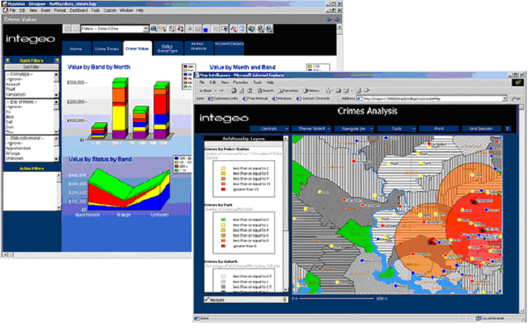
The highest level of integration for technology is always at the functional level.9 It is here where we see an effort to make transparent the use of underlying technology for the user.Map Intelligence is one example of leading technology that achieves this level of integration; simplifying the integration of geographical data and traditional data sources into your BI applications.The technology efficaciously applies traditional data, geographic data, and advanced visualization into cohesive BI applications.Illustrated in Figure 1.0 and Figure 2.0 are dashboards implemented using Hyperion Dashboard builder and Map Intelligence.
With Map Intelligence, there are several immediate advantages:
Faster Visualization. With the Map Intelligence engine, the visualizations can be generated much faster. This is particularly important when providing ad hoc querying where users are essentially allowed to visually interrogate the data domain.
GIS Link. The engine of Map Intelligence provides all the necessary connectivity to query spatial and logical databases, not only enhancing the attributes available for analysis, but making the visualization effortless.This linking, of course, can go beyond spatial and traditional data domains.Procedures for statistical analysis, data mining, and other analytical processes and attribute data can be made available just as easily.The combined visualization helps users understand complex attribute relationships.
Analytic Granularity. Another advantage is that Map Intelligence resolves the granularity of your query.This means that any attribute data associated with a spatial visualization is of the same resolution. Map Intelligence handles the links and, therefore, level of detail applicable.There is no additional filtering that users are required to include.
The combined advantage is where leading products like Map Intelligence excel.Establishing a common analytic platform that reaches across disparate data and technologies, bringing them together is a single, cohesive, synchronized data discovery event for user communities.
Map Intelligence is a middleware component between your BI application and a geographic information system and other traditional data sources.It is deployed to act as a link between a GIS server and the BI client.The Map Intelligence server itself is a BI client and currently supports both Hyperion Dashboard Builder and Excel clients.
The back end is an application server that resides within a Web server (servlet) environment.The application server component is responsible for interactions with the underlying map service.(Refer to Figure 3.0.) All spatial capability is derived and served up from the map service being accessed, such as MapXtreme from MapInfo10 or ArcIMS from ESRI Inc.11, both of which are internet map server. Future releases of Map Intelligence are planned to interface with ArcGIS from ESRI and Envinsa from MapInfo to take advantage of advanced spatial analytic and presentation capabilities.
Conclusion
People think visually.We need to see our logic.12 Map makers have always known that a map is not just a tool for showing how to get from here to there.It is a method, a technique for organizing and embedding knowledge in a manner readily understood by all.
But the typical BI tools we implement for our companies are far more simplistic.Consequently, many BI environments place the burden of discovery and information insight on the user with little help other than spreadsheets, columnar reports, and, of course, pie charts.
Because of mature applications like geographic information systems and leading technology such as Map Intelligence, it is now possible to design BI environments that support both traditional and spatial data.It is the obvious application and success of such products that keep us from simply ignoring the BI value of spatial analytics.Top companies around the world have made GIS and the related spatial analysis a top priority.Companies such as Sears, arguably the poster child of what GIS can do for your business, invested a few million dollars in GIS technology for its logistics application and saves $52 million per year as a result.13
Tools like Map Intelligence ensure the transparent integration of visualization technology and spatial data into BI applications.As products like Map Intelligence lead us into the future, data visualization evolves into a means of transforming data quickly into human understanding.14
References
1. Card, Stuart K.et al., Readings in Information Visualization: Using Vision to Think, Morgan Kaufmann Publishers, 1999.
2. Dresner, Howard, "Predicts 2004: Business Intelligence Technology Directions", Gartner Inc., December 5, 2003.
3. Gonzales, Michael L., "Alleviating Spatial Constraints", Intelligent Enterprise, August 18, 2000.
4. Ibid., "Breaking Out of the Warehouse", Intelligent Enterprise, September 17, 2003.
5. Ibid., IBM Data Warehousing,, Wiley Publishing Inc., 2003.
6. Ibid., "More than Pie Charts", Intelligent Enterprise, November 13, 2004.
7. Ibid., "Picture This! A Spatially Aware Data Warehouse", Journal of Data Warehousing, Volume 6, Issue 3, Summer 2001.
8.Ibid., "Seeking Spatial Intelligence", Intelligent Enterprise, January 20, 2000.
9. Ibid., "The New GIS Landscape", Intelligent Enterprise, February 1, 2003.
10. Spence, Robert, Information Visualization, Addison-Wesley Publishing Co., 2000
11. Sullivan, Dan, "Vision of Intelligence", Intelligent Enterprise, May 28, 2002
12. Tiedrich, Alan, "Business Intelligence Tools: Perspective", Gartner Inc., June 19, 2003.
13. Ibid., "Cool Vendors in BI, BAM and Data Warehousing", Gartner Inc., March 25, 2004.
14. Woodbury, Henry, "Why Your Ideas Need Visual Explanation", Dynamic Diagrams Inc., October 2003.
Acknowledgment
Some content for this paper was derived from Michael L.Gonzales's book IBM Data Warehousing, published by Wiley, 2003, Ver 4.1 - reprint by permission.
Spatial Business Intelligence HandsOn-BI, LLC Copyright © 2004 All Rights Reserved
Our ability to exploit the massive amounts of complex, disparate data will never be resolved by the traditional technology we introduce or the common techniques we attempt to implement.Pie charts and other typical graphics, for example, fall short of supporting better decision making.A pie chart is simply not sufficient to interrogate a large OLAP cube or provide the necessary insight from the data pushed into our dashboards.1
Innovative visualization technology is necessary to effectively synthesize detailed data into information and present this content in an understandable manner to users.However, for leading business intelligence (BI) environments, this visualization must be based on spatial (geographic) data.Effective BI, therefore, is dependent on the following two capabilities:
Visualization.Interrelationships, specifically those based on geographic data, that might otherwise be difficult to describe or explain, are often readily understood when visually presented.Irrelevant of how abstract or complex, effective visualization exposes the information insight.
Spatial Data. Typical BI systems handle the who, what and when, but the where is vastly underexploited.2 Spatial data, the where of BI, does two things: First, it enhances the who by binding third party data from companies like Dun & Bradstreet to your existing data.Second, it enables analysis for the where.
Integrating spatial data and visualization technology delivers accurate, high impact information content.Tools like Map Intelligence, from Integeo Pty Ltd,3 foster this integration for BI applications, transforming data into human understanding and actionable insight.
Introduction
The traditional means of presenting data to users have been columnar reports, either printed or viewed on the screen in a spreadsheet fashion, or simple graphs and charts like histograms or pie charts.But given the complex interrelationships of multidimensional data, can you effectively interrogate a large OLAP cube using a simple pie chart? Can you really report and communicate all the necessary information content through your dashboard with just a bar graph? The obvious answer is no.4
Moreover, by excluding geographic (spatial) information in the analytic landscape, any data made available for analysis is artificially constrained; consequently, decision making is compromised.Only by spatially enabling your information can you best manage an enterprise.5 The role of spatial analysis in business is too important to be left to specialists.Everybody in the enterprise needs access to the geospatial information.
Humans think visually - spatially. Therefore, leading BI environments provide visualization techniques based on spatial relationships.The following two components foster the synthesis of information such that insight can easily be recognized by users:
Spatial Data.Our current systems handle the who, what and when, but the where is vastly underexploited.6 Spatial data enhances the who by creating new informational content (binding substantial third party data from companies like Dun & Bradstreet to your existing data) as well as directly enabling analysis for the where.Spatial data is such a boon to analysis that the definition of a modern warehouse should include "space-centric" along with traditional characteristics such as "integrated" and "time-variant."
Visualization. Interrelationships that might otherwise be difficult to describe or explain are often readily understood when visually presented.The visualization helps the analyst interrogate the data, while also serving as an excellent means of explaining the information to a broader audience, including executives and customers.
It is the visualization of spatial relationships that delivers accurate, high impact informational content, enabling decision makers to gain a fast understanding of the critical issues that lie just beneath the surface of the obvious data.
This paper explores the value of spatial data as it relates to geographic information and the visualization of this spatial data for effective analysis.
Spatial Business Intelligence
No one questions the value that temporal data brings to the analytic table.Without it we have no definition to our analysis, only amorphous results.But time is only one pylon supporting the entire spectrum of analysis available.Space is another.
All data warehouses, data marts, operational data stores (ODS), OLAP cubes, and just about every other database in your organization - from personal contact databases to those underpinning your corporate ERP, CRM, SCM and other operational systems -- are full of spatial data.This data comes in the form of addresses for customers, stores, offices, warehouses and virtually anything else that might have an address associated with it.Exploiting this data for more than mailing labels is really no longer optional; it's imperative.These addresses, kept clean and meticulously maintained in warehouses, represent the foundation of spatial analysis. The challenge for most data architects and project planners is to appreciate how addresses can be used to enhance and extend the analytic landscape for user communities.
The Insight Space Provides
Just as a date explodes data into a wealth of analytical power, so too does an address.From addresses, you can build one or more elaborate space-related dimensions and data-access-layer applications.Attributes of the dimension could include the following: longitude and latitude, street address, street block, city quadrant, ZIP code, street, city, county, state and country.And these space-centric attributes can be combined with a variety of demographic characteristics such as household income, education, family size and home value, or numeric characteristics such as drive time between customers' homes and their favorite stores.7
Space is an information windfall for the analyst and is as critical to the process of interrogating our data as is time.There are even aspects of space that go beyond the value of time.For example, where time has a single, constant perspective, space can represent information about what or who is located at a place as well as about how a physical location is related to other locations or geographic features.
The Where Of Business Intelligence
Many business problems explicitly or implicitly require that geography (space) be taken into account. Consider the following everyday business questions:
- Where are my customers located?
- How big is my market area?
- What is my share of the market area?
- Which market areas offer the greatest potential for growth?
- What is the spending potential for my product in this market?
- How many stores can this market support?
- What's the best mix of products to carry in each store?
- Where should I target my direct mailing to get the most from my marketing dollars?
- What media channel will reach the audience I'm targeting?
- Where should I open new sites?
- Can I consolidate sites without hurting customer service?
Common BI tools do a good job at analyzing the basic who, what, when, and how questions that characterize things such as customers.Data needed to discover who is buying what product on what day through what channel is captured with virtually every transaction.From these modest data elements, data mining tools can identify cross-sell and up-sell opportunities, determine market-basket relationships, profile customers, and evaluate distribution channels.
But these traditional analysis tools fall short in answering the tougher questions of why people buy and where customers live in relation to their purchases.Although the why of a transaction is rarely captured with it, the where of the transaction, its geographic location, is almost always captured.In fact, multiple locations are often captured.Ship-to, bill-to and customer contacts are all often captured at companies everywhere.But unlike the dimensions of who, what, and when (customer, product, time), the where gets little attention.
Visualization, Spatial Analysis & Business Intelligence
For centuries, maps, graphs, charts, and various diagrams have provided visual cues to show context and connections, allowing measurement and evaluation.8 Irrelevant of how abstract or complex, effective visualization exposes the information insight lying just beneath the obvious data.Put simply: Visualization is a means to present highly complex and abstract data without overwhelming the user.
Today, visualization technology remains one of the most effective means to glean insight from the heavy volume of detailed data our organizations continuously generate.It provides the most efficient method for revealing problems or opportunities in a single, cohesive view for users, and shows interrelationships that might otherwise be difficult to describe or explain all of which leads to faster and better decision making.
Take note, however, that visualization must be more than simple graphical presentations.There are several differences between visualizations based on spatial data and those visuals created for traditional structured data or CAD or graphic applications.Following are four critical distinctions:
Utilizes explicit real-world relationships.In spatial data, there is an explicit relationship between the real-world geometric feature and its associated attribute information, so that both are always available when you work with the data.If you select particular features displayed on a map you can automatically select the records containing the attributes of these features whether they reside in separate tabular files or in a database.So, when you click on a customer, for example, you have access to all the tabular information associated with that customer such as address, sales, products purchased, and whatever else your ODS or data warehouse may capture on the customer.
Geo-coded to known locations around the globe.Spatial data is geo-referenced to known locations on the Earth's surface.To ensure that location is accurately recorded, spatial data always employs a specific coordinate system, unit of measurement and map projection.When spatial data is displayed, it has a particular scale just like any paper map.Graphic files used in computer-aided drafting (CAD) programs or other commercial graphics packages are typically stored in units such as inches rather than geographic coordinate systems required for spatial data.
Exploits specific geographic features.Spatial data is designed to enable specific geographic features and phenomena to be managed, manipulated and analyzed easily and flexibly to meet a wide range of needs.Other types of graphic data may be oriented solely towards presentation and display, and may store features such that they can be analyzed in only a limited number of ways.For example, drive-time analysis is not possible with linear data created by a CAD or graphics application, because there is no explicit network connectivity and direction maintained.Similarly, none of the graphics objects created in these packages have any idea where they are in relation to all the other graphics, which prohibits any kind of proximity or adjacency analysis.They are just "dumb" graphic objects.
Thematically organized.Spatial data is organized thematically into different layers, like the layers of an onion.There is one layer for each set of geographic features or phenomena for which information will be recorded.For example, census tracts, streets, sales territories, and customer locations will each be stored as separate spatial layers.CAD or other graphic applications would record these features all together.Spatial layering makes it easier to manage and manipulate the data, especially as much of the power of working geographically comes from being able to analyze the spatial relationships among different geographic layers.
Spatial BI at Work
The highest level of integration for technology is always at the functional level.9 It is here where we see an effort to make transparent the use of underlying technology for the user.Map Intelligence is one example of leading technology that achieves this level of integration; simplifying the integration of geographical data and traditional data sources into your BI applications.The technology efficaciously applies traditional data, geographic data, and advanced visualization into cohesive BI applications.Illustrated in Figure 1.0 and Figure 2.0 are dashboards implemented using Hyperion Dashboard builder and Map Intelligence.
 |
Map Intelligence reaches
across the IT architecture to source the data where it is stored
natively.Consequently, there is no extra effort necessary on the part
of IT or the user to exploit the combined data and technology.All the
heavy lifting is done by Map Intelligence, from source, to interactive
querying, to visualizations.
 |
With Map Intelligence, there are several immediate advantages:
Faster Visualization. With the Map Intelligence engine, the visualizations can be generated much faster. This is particularly important when providing ad hoc querying where users are essentially allowed to visually interrogate the data domain.
GIS Link. The engine of Map Intelligence provides all the necessary connectivity to query spatial and logical databases, not only enhancing the attributes available for analysis, but making the visualization effortless.This linking, of course, can go beyond spatial and traditional data domains.Procedures for statistical analysis, data mining, and other analytical processes and attribute data can be made available just as easily.The combined visualization helps users understand complex attribute relationships.
Analytic Granularity. Another advantage is that Map Intelligence resolves the granularity of your query.This means that any attribute data associated with a spatial visualization is of the same resolution. Map Intelligence handles the links and, therefore, level of detail applicable.There is no additional filtering that users are required to include.
The combined advantage is where leading products like Map Intelligence excel.Establishing a common analytic platform that reaches across disparate data and technologies, bringing them together is a single, cohesive, synchronized data discovery event for user communities.
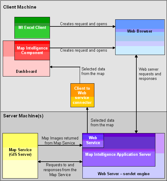 |
Figure 3.0 - Map
Intelligence Architecture (for larger image Click
Here)
Map Intelligence is a middleware component between your BI application and a geographic information system and other traditional data sources.It is deployed to act as a link between a GIS server and the BI client.The Map Intelligence server itself is a BI client and currently supports both Hyperion Dashboard Builder and Excel clients.
The back end is an application server that resides within a Web server (servlet) environment.The application server component is responsible for interactions with the underlying map service.(Refer to Figure 3.0.) All spatial capability is derived and served up from the map service being accessed, such as MapXtreme from MapInfo10 or ArcIMS from ESRI Inc.11, both of which are internet map server. Future releases of Map Intelligence are planned to interface with ArcGIS from ESRI and Envinsa from MapInfo to take advantage of advanced spatial analytic and presentation capabilities.
Conclusion
People think visually.We need to see our logic.12 Map makers have always known that a map is not just a tool for showing how to get from here to there.It is a method, a technique for organizing and embedding knowledge in a manner readily understood by all.
But the typical BI tools we implement for our companies are far more simplistic.Consequently, many BI environments place the burden of discovery and information insight on the user with little help other than spreadsheets, columnar reports, and, of course, pie charts.
Because of mature applications like geographic information systems and leading technology such as Map Intelligence, it is now possible to design BI environments that support both traditional and spatial data.It is the obvious application and success of such products that keep us from simply ignoring the BI value of spatial analytics.Top companies around the world have made GIS and the related spatial analysis a top priority.Companies such as Sears, arguably the poster child of what GIS can do for your business, invested a few million dollars in GIS technology for its logistics application and saves $52 million per year as a result.13
Tools like Map Intelligence ensure the transparent integration of visualization technology and spatial data into BI applications.As products like Map Intelligence lead us into the future, data visualization evolves into a means of transforming data quickly into human understanding.14
References
1. Card, Stuart K.et al., Readings in Information Visualization: Using Vision to Think, Morgan Kaufmann Publishers, 1999.
2. Dresner, Howard, "Predicts 2004: Business Intelligence Technology Directions", Gartner Inc., December 5, 2003.
3. Gonzales, Michael L., "Alleviating Spatial Constraints", Intelligent Enterprise, August 18, 2000.
4. Ibid., "Breaking Out of the Warehouse", Intelligent Enterprise, September 17, 2003.
5. Ibid., IBM Data Warehousing,, Wiley Publishing Inc., 2003.
6. Ibid., "More than Pie Charts", Intelligent Enterprise, November 13, 2004.
7. Ibid., "Picture This! A Spatially Aware Data Warehouse", Journal of Data Warehousing, Volume 6, Issue 3, Summer 2001.
8.Ibid., "Seeking Spatial Intelligence", Intelligent Enterprise, January 20, 2000.
9. Ibid., "The New GIS Landscape", Intelligent Enterprise, February 1, 2003.
10. Spence, Robert, Information Visualization, Addison-Wesley Publishing Co., 2000
11. Sullivan, Dan, "Vision of Intelligence", Intelligent Enterprise, May 28, 2002
12. Tiedrich, Alan, "Business Intelligence Tools: Perspective", Gartner Inc., June 19, 2003.
13. Ibid., "Cool Vendors in BI, BAM and Data Warehousing", Gartner Inc., March 25, 2004.
14. Woodbury, Henry, "Why Your Ideas Need Visual Explanation", Dynamic Diagrams Inc., October 2003.
Acknowledgment
Some content for this paper was derived from Michael L.Gonzales's book IBM Data Warehousing, published by Wiley, 2003, Ver 4.1 - reprint by permission.
Spatial Business Intelligence HandsOn-BI, LLC Copyright © 2004 All Rights Reserved
From Our Homepage
Saying Farewell to an Amazing Journey
Communicating with Maps
Is There a GIS Career Ladder?
What does it mean to be geospatially smart? Series
Ways Real Estate and Property Developers Utilize Melissa GeoData for Data-Driven Decisions
Unlocking Value From Daily Satellite Imagery and Insights
Maximizing the Value of Your Address Data with Geo Addressing
How Indoor Mapping Enhances the Security of Smart Buildings
Look Ahead: AI, Location Intelligence and Efficiency
Collaboration Takes on Sea Level Rise & Dynamic Technology Environments
Brownies for Brownfields
Has Everything Been Mapped Already?
How Is Data Literacy Changing in an Artificial Intelligence Landscape
Portfolios for GIS Professionals: More Than Just Maps
How to Create a Distance Matrix in QGIS - A Step-by-Step Guide
7 Ideas for Bringing GIS into the K-12 Classroom
The Geography of Movement