Information or Misinformation?
It happens all the time in action movies: the police have planted a homing device on the culprit they are pursuing. Having determined the exact whereabouts of this nefarious individual, they rush over to his lair and break down the door ... only to find that the lair is empty, and the criminal is nowhere to be found. Only a blinking red homing device remains behind, mocking them. The police's information has misled them.
Any industry that utilizes location-based services (LBS) has experienced this type of misinformation to some extent. Take, for example, the plumbing service that wants to locate its field workers while they're out on service runs. Often the precise street address displayed for a worker is actually that of the center of a large region of location uncertainty or that of the nearest cell phone tower, not for the worker. The variance between the two locations could be more than a mile.
This misinformation can be traced to the traditional reverse geocoding technology that has historically underpinned LBS. Traditional reverse geocoding works by analyzing a street network model database and associating a latitude and longitude coordinate with the nearest street network link. The location is then returned in the form of human-recognizable addresses.
So far, so good. But these traditional methods become rudimentary and increasingly imperfect when we apply them to coordinate locations that have varying levels of uncertainty associated with their accuracy. Uncertainties can be caused by a variety of factors, from the quality of the GPS chip being used, to interferences like tree cover, to whether someone is indoors rather than outdoors.
Regardless of the cause, the end result is always the same: misleading information can result from the use of traditional reverse geocoding to return addresses for locations that have relatively significant inaccuracies associated with them. This becomes a real problem when that misleading information is then used by the system for further processing, or by the end user. For example, our plumbing service might dispatch a worker to a customer site, thinking he is much closer to the destination than is actually the case. Potential delays - and unhappy customers - await him, due to the faulty information.
Enter Autodesk's Intelligent Reverse Geocoding (IRG). Coupling intelligent heuristics with traditional geocoding, IRG returns address results that better reflect the various inaccuracies associated with locations.
IRG is the brainchild of Autodesk's location-based services division. A spin-off of Autodesk's geospatial software division, the LBS group saw an opportunity to apply its knowledge and experience toward addressing some of the challenges the industry faced when communicating location information. The following example illustrates the difference between traditional reverse geocoding and IRG. Let's say that you'd like to know if your child is on her way back home from a movie or is still in the theater.
Traditional reverse geocoding returns her location as:
IRG, on the other hand, returns her location as:
Under the Hood
A closer look "under the hoodï¿1⁄2 demonstrates how IRG arrives at this type of meaningful result. For starters, it introduces a set of defined rules that are used to determine how the geocoder should behave, based on the characteristics of the source coordinate information. Characteristics include (but may not be limited to) location uncertainty information and proximity to the nearest street network link or point of interest. Coordinate information converted by the intelligent reverse geocoder into a human-recognizable format can take the form of anything from a street address with civic number detail to a city name or a nearby point of interest. The format returned to the application is that which best considers the unique and dynamic characteristics of the source location.
The result of all this sophisticated technology is that users and applications alike are returned valuable information that more accurately reflects the integrity of the original source location information. And the more meaningful the information, the more actionable and usable it is to the user.
News You Can Use
It is this very quality of providing "news you can useï¿1⁄2 that makes IRG so valuable. Far from being technology-for-the-sake-of-technology, IRG has a direct impact on improving the communication of location information - and making misleading location-based information a thing of the past.
The availability of more accurate information, in turn, leads to better usability, wider acceptance and increased adoption of location-based services. This is good news for the wireless network operators who are looking to offer the next generation of these services - but it's even better news for consumers who have been looking for a compelling reason to use them.
It happens all the time in action movies: the police have planted a homing device on the culprit they are pursuing. Having determined the exact whereabouts of this nefarious individual, they rush over to his lair and break down the door ... only to find that the lair is empty, and the criminal is nowhere to be found. Only a blinking red homing device remains behind, mocking them. The police's information has misled them.
Any industry that utilizes location-based services (LBS) has experienced this type of misinformation to some extent. Take, for example, the plumbing service that wants to locate its field workers while they're out on service runs. Often the precise street address displayed for a worker is actually that of the center of a large region of location uncertainty or that of the nearest cell phone tower, not for the worker. The variance between the two locations could be more than a mile.
This misinformation can be traced to the traditional reverse geocoding technology that has historically underpinned LBS. Traditional reverse geocoding works by analyzing a street network model database and associating a latitude and longitude coordinate with the nearest street network link. The location is then returned in the form of human-recognizable addresses.
So far, so good. But these traditional methods become rudimentary and increasingly imperfect when we apply them to coordinate locations that have varying levels of uncertainty associated with their accuracy. Uncertainties can be caused by a variety of factors, from the quality of the GPS chip being used, to interferences like tree cover, to whether someone is indoors rather than outdoors.
Regardless of the cause, the end result is always the same: misleading information can result from the use of traditional reverse geocoding to return addresses for locations that have relatively significant inaccuracies associated with them. This becomes a real problem when that misleading information is then used by the system for further processing, or by the end user. For example, our plumbing service might dispatch a worker to a customer site, thinking he is much closer to the destination than is actually the case. Potential delays - and unhappy customers - await him, due to the faulty information.
Enter Autodesk's Intelligent Reverse Geocoding (IRG). Coupling intelligent heuristics with traditional geocoding, IRG returns address results that better reflect the various inaccuracies associated with locations.
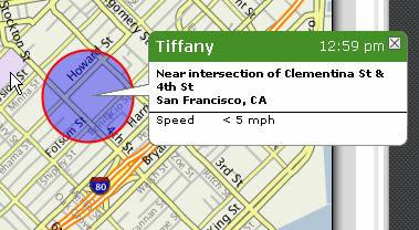
IRG is the brainchild of Autodesk's location-based services division. A spin-off of Autodesk's geospatial software division, the LBS group saw an opportunity to apply its knowledge and experience toward addressing some of the challenges the industry faced when communicating location information. The following example illustrates the difference between traditional reverse geocoding and IRG. Let's say that you'd like to know if your child is on her way back home from a movie or is still in the theater.
Traditional reverse geocoding returns her location as:
- "111 Las Gallinas Ave. San Rafael CA"
IRG, on the other hand, returns her location as:
- "Within 2 miles of Northgate Mallï¿1⁄2
 |
Under the Hood
A closer look "under the hoodï¿1⁄2 demonstrates how IRG arrives at this type of meaningful result. For starters, it introduces a set of defined rules that are used to determine how the geocoder should behave, based on the characteristics of the source coordinate information. Characteristics include (but may not be limited to) location uncertainty information and proximity to the nearest street network link or point of interest. Coordinate information converted by the intelligent reverse geocoder into a human-recognizable format can take the form of anything from a street address with civic number detail to a city name or a nearby point of interest. The format returned to the application is that which best considers the unique and dynamic characteristics of the source location.
The result of all this sophisticated technology is that users and applications alike are returned valuable information that more accurately reflects the integrity of the original source location information. And the more meaningful the information, the more actionable and usable it is to the user.
News You Can Use
It is this very quality of providing "news you can useï¿1⁄2 that makes IRG so valuable. Far from being technology-for-the-sake-of-technology, IRG has a direct impact on improving the communication of location information - and making misleading location-based information a thing of the past.
The availability of more accurate information, in turn, leads to better usability, wider acceptance and increased adoption of location-based services. This is good news for the wireless network operators who are looking to offer the next generation of these services - but it's even better news for consumers who have been looking for a compelling reason to use them.
From Our Homepage
Saying Farewell to an Amazing Journey
Communicating with Maps
Is There a GIS Career Ladder?
What does it mean to be geospatially smart? Series
Ways Real Estate and Property Developers Utilize Melissa GeoData for Data-Driven Decisions
Unlocking Value From Daily Satellite Imagery and Insights
Maximizing the Value of Your Address Data with Geo Addressing
How Indoor Mapping Enhances the Security of Smart Buildings
Look Ahead: AI, Location Intelligence and Efficiency
Collaboration Takes on Sea Level Rise & Dynamic Technology Environments
Brownies for Brownfields
Has Everything Been Mapped Already?
How Is Data Literacy Changing in an Artificial Intelligence Landscape
Portfolios for GIS Professionals: More Than Just Maps
How to Create a Distance Matrix in QGIS - A Step-by-Step Guide
7 Ideas for Bringing GIS into the K-12 Classroom
The Geography of Movement