The Benefits of GIS/911 Integration
An Approach Worth Emulating
F. Peirce Eichelberger
GIS Manager, Chester County, PA
Abstract--This article will highlight the many benefits of GIS and 911 integration as experienced in Chester County, PA.The County has taken an integrated approach to GIS and 911-- from MSAG/geofile building through current implementation and support.The advantages of integration are many--addresses can be leveraged for a far larger number of users, exact addresses can be placed in a context of address range information, precisional accuracy of GIS data and maps is usually better, focus on core staff competencies, improved division of labor, economies of scale, improved use of software tools, and a more extensive geographic systems/database model for all address and geographic referencing features.Each of the benefits will be enumerated with examples and details.
The structure and functions of the integrated GIS/911 approach will be covered as will roles and responsibilities.The special relationship the County has built with its 73 Municipalities will also be described.Advantages of using the GIS framework for address and street name maintenance are also manyfold. Address work-flows and procedures will also be described.The systems/database model of addresses will be described along with the geofile for CAD and the GIS' map/vector/geographic data model.Ideas regarding GIS and 911 functional integration will also be shared with the attendees.
Introduction/Audience
The audience of interested parties for this discussion should include the following:
• current 911 managers and staff interested in using new GIS tools to improve existing processing,
• GIS managers and staff who should be thinking about improved address access to all GIS data and maps, and
• government managers and decision-makers who should be thinking about economies of scale, the role of addresses and address functions throughout government, and improved work-flow among departments predicated on key geographic, common denominators.
Advantages of GIS/911 Data Integration
Experience is now showing that there are many benefits of 911/GIS data integration.While this implies some form of organizational change, ultimate success depends on focused staff doing the jobs they do best.The focus in this section is upon data integration, the next section will describe the needed organizational changes that might be needed to attain these benefits.
The benefits of 911/GIS integration from a data perspective are:
• improved address leveraging by all that need better addresses
• newer tools to do a much better job of address assignment, maintenance, editing and utilization
• earlier focus on data/address maintenance from an ongoing development perspective, and
• improved division of labor and focus on core competencies.
These benefits will be described in additional detail below.
Improved Address Leveraging
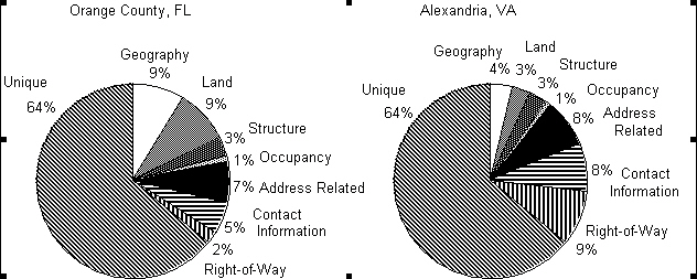
In the GIS arena we are quickly realizing that addresses are an essential element in providing access among various maps, databases and many applications. While 911 requirements are critical consumers of address-based data, they are certainly not the only ones! Addresses truly are the "locus of GIS" and we are finding that addresses are used and needed by nearly every government computer application that deals with people, places, things or events[1].Addresses have been found to be the most common of "geographic denominators" among applications in all governmental settings, i.e.cities and counties, sunbelt and rust-belt locales, old and new places.The pie charts (Figure 1) on the next page show the importance of addresses in governments of all types.Note the "address related" darkened, pie slices at 7-8% of total data elements.These pie charts are very representative of dozens of GIS design studies that found similar percentage rates for address data elements across a broad spectrum of local governments.
With so many other potential uses of accurate and up-to-date addresses, there are important economies of scale to allow for heightened address utilization by everyone that needs them.This also provides for the adage "the more people looking at and using something, chances are that it will be kept current and that errors will be fixed or at least noted".Address clean-ups come from many, many sources not just MSAG (Master Street Address Guide) "fall-outs".
Importance of Address Information
Figure 1
In fact, we want to identify address problems well before an emergency call for service is needed.Waiting for MSAG file "fall-out" is unacceptable.This means that improved addresses are available for everyone, not just 911, and that all are participating in address use and edits, not only in just an emergency call situation.
Addresses are used and needed in most governmental activities.As these functions work at collecting, editing and using good addresses, a central repository and consistent data model will benefit everyone.Important too, is that addresses should be assigned/examined much earlier in the development cycle, before the streets are built and utilities are provided, prior to most building activities.
Improved Tools
The GIS' base map provides for the strongest geographic framework for accurate street and address data capture, editing and development.Often times the GIS base map is also built upon a photogrammetric base that indicates roads, right-of-ways and improvements.The single line street map/database should be the basis for all address range data used for 911 call management and subsequent dispatching.The unified database should also drive the assignment of all individual addresses, so all E-911 addresses needed also reflect the proper address ranges, street types, directions and municipal designations as determined by the single line street map/database.
The mapping, database and reporting tools common to GIS implementation are just what 911 data needs to be even more accurate, consistent and up-to-date. The ability to view right-of-ways and to see whether or not improvements exist for addressing is a powerful quality control feature of GIS.All too often the MSAG file is built in a non-graphic context with address ranges and segments poorly defined to the "face of the earth", actual intersections, hundred blocks, etc.
The GIS also allows for powerful geographic edits and less error prone data maintenance, as key geography is built using the powerful topological structures of the GIS.Segments and street name synonyms, i.e.County Route 200 and State Route 113, are built using visible features, closely related to the proper hundred block orientation.The powerful graphics of the GIS also quickly show the orientation of streets to assigned addresses.Bad address parity or addresses "out of sequence" are quickly located by using the GIS.Most importantly all addresses should be cross-referenced with "mappable" GIS features such as street segments, intersections, parcels, map polygons or building footprints.This cross-referencing alone is the one of the most powerful features of 911/GIS integration, since it helps account for all known or assigned addresses.This also builds the relationship among all exact addresses and the address ranges from a graphic perspective. This makes it easier to correlate all MSAG(2) address ranges with E-911 exact addresses.The maps become the most powerful data quality control technique, since it helps "zoom in" to addressing problem areas quickly and visually, rather than perusing large reports or database dumps.
We use an improved MSAG(2) format which defines each street segment per recognizable street intersections, not the "span file" segments which are typical in most non-mapped, MSAG implementations.
Focus on the Development Perspective
Keeping addresses, street names and address range information up-to-date just for 911 and emergency dispatch purposes is a great deal of work in rapidly growing areas.Keeping GIS maps and related land records up-to-date is an equally daunting task.There are tremendous economies of scale if both update work-flows can be orchestrated to be maintained in a more simultaneous fashion!
As the GIS' base maps are maintained, as new subdivisions are approved, platted and recorded, as right-of-ways are managed, as building permits are finalized, etc.all these steps affect address assignments.With a consolidated approach to 911/GIS data integration, these work-flow processes can be developed to ensure accurate and timely database/map maintenance.
Advantages of integration are especially felt in areas where addressing is a local responsibility of the cities and townships.Much coordination is required for interaction with the local jurisdictions.Their interest in GIS is also another good reason to leverage cooperative events, where daily communication helps to ensure that all have access to the very best and latest data.
Division of Labor
Quite frankly there must be an elevation of addressing practices and a resultant increase in professionalism.Addressing staff with a closer affinity to GIS procedures helps raise overall awareness about the importance of addresses for the community at large.Emergency services and 911 staff will benefit from a narrower focus on dispatch and larger emergency preparedness requirements. This implies a "lock-step" degree of coordination usually missing in most organizations. This coordination and division of labor is paramount to successful implementation, if it does not exist, if it is found wanting in any manner, if things change with differing staff, etc.the economies will be quickly lost.
The division of labor and the need for close coordination might also benefit from an agreed upon Service Level of Agreement which spells-out, in writing, agreed to procedures, data quality and timing parameters, so the success of the relationship can be measured.Note that if mapping gets back-logged, or resources or lost for important daily maintenance activities, the whole arrangement can become completely unworkable, very quickly!
Organizational Structure
The support of GIS/911 integration is predicated on a non-redundant organizational model.Key staff must be organized, dedicated and directed to accomplish daily goals of accurate, consistent address and geographic referencing maintenance, else integration is a pipe dream and will be a detriment.GIS staff will need to fully understand their role, their work will be of life and death consequences, and will be used seven days a week, 24 hours a day.Nothing like 911 support brings the GIS team out of the shadows and into the forefront of daily automation.With 911 support, GIS explodes from the past of "producing pretty maps once a month for the managers" to providing daily services of critical consequences.GIS becomes mainstream and begins to support all addressed based functions of government, not just dispatch and 911.
At Chester County, the GIS Addressing team is responsible for nearly two dozen activities organized into seven, major work program tasks, see Figure 2 on the next page.Key tasks will be described in the following sections.
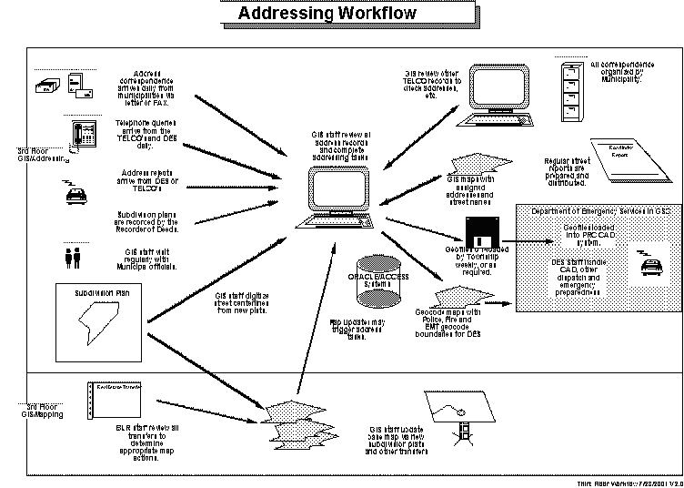
GIS/Addressing Workflow
Figure 2
Address Reconciliation/Situs Addressing
Municipal Liaison/Exchange
As you could image with 73 Townships, Cities and Boroughs a large effort is needed to work with key staff responsible for addressing and development review.A constant flow of correspondence and data is moving back and forth between the County and its municipalities.As new addresses are assigned, building permits issued, new streets paved or address problems uncovered--much work is needed to keep all the "geography" accurate and consistent.
In the Commonwealth, all actual address assignments rest with the municipalities. The County is responsible for the countywide compilation of all addresses for dispatch and 911 call handling.
Through various stages of the 911/GIS implementation, many distinct tasks have occurred:
• approval and agreement as to proper street names, street directions, i.e.N, S, E or W and street types, i.e.RD, ST, BV, etc.
• approval of address ranges along all street segments in the County
• address problem identification and verification
• address problem correction and edits
• exact, situs address determination
• situs address(es) cross-referenced to the proper ownership parcel, and
• address documentation and database construction.
Address Reconciliation/Situs Addressing
This has been a multi-year task for Chester County.By using the initial address ranges established for the County's E-911 program, the next step was to ensure that each, exact address was also properly assigned and within the proper address range, i.e.proper hundred block, odd or even side of the street and in the correct sequence--in ascending numerical order.Most importantly the addresses were properly cross-referenced with the proper "parcel" in the GIS' map, so address related data can always be reliably "mapped".This work involves much municipal cooperation.County staff literally build the entire address databases from the best available data and provide it to each of the municipalities in a report, map or digital format for their review and sign-off. Many maps and address edits or corrections are also "flagged" for further attention. The work is reviewed with each municipality representative in a face-to-face setting.
Nearly 30 municipalities have returned their reviewed reports to the County.For the other municipalities we are focusing on the address Atlas and address map presentation format to elicit responses.These map products (in ARCView) can more readily highlight areas with addressing issues.The majority of the remaining municipalities are eager to review the maps indicating possible address problems.
Follow-on work may lead to other 911 edits or TELCO updates and/or corrections.
This is a key area where future Internet enabled applications would allow for direct data and function sharing of all important address information. Currently a street report is available at the County's web site.This helps keep street names unique, by Municipality, during subdivision plan review.
Process Municipal Requests/Correspondence
FAXes, letters and telephone calls are received daily from the municipalities and refer to new addresses assigned, address problems corrected, street vacations, new subdivisions, plats approved, etc.This correspondence will lead to a work-flow/ripple affect throughout many GIS address functions.This work-flow is very critical due to the emergency service nature of 911 data.It must be accurate, up-to-date--seven days and week and 24 hours a day!
In the future all of the communication should be web enabled!
Verizon Research
We are the only GIS in Pennsylvania with direct access to our major TELCO databases.This allows GIS staff to ensure very accurate and timely record/database maintenance.Verizon is the host TELCO for the MSAG file.The CLEC's and other TELCO's send their changes to GIS for forwarding to Verizon, as needed.The CESNA (Customer Emergency Service Number Assignment) terminal (in GIS) is used to access the MSAG file at Verizon.It is the MSAG that actually is used to switch the emergency calls to the proper PSAP (Public Safety Answering Port) for subsequent dispatching of the correct emergency vehicle.
Twice a year, County staff also assist Verizon in a major record compare of all exact addresses against the MSAG file as another important QA/QC check. Our most recent compare in April, 2001 netted a very high 98.6% match rate!
ANI/ALI Research
If an address is used during dispatch of an emergency vehicle and the address does not "hit" the proper address range/segment an error is reported for follow-up.As the address error is researched, various other corrections/processing may occur.As always, the internal consistency of the address and geographic records must be maintained and kept current.Problems are researched by GIS staff, before transmission to the appropriate TELCO.
Conflation Phase 3
The GIS' single line, street maps came from two entirely different sources. Originally, the TIGER file was used to encode the Police and Fire zones and was used to build the dispatch geofiles.With many changes and edits it finally became appropriate that this file should be "conflated" or registered to the GIS' base map.Along with GIS map development, a photogrammetrically accurate street centerline file was built as well.Starting in the summer of 1999, conflation work began to combine the two centerline files into one, with more accurate address attributes and good GIS map, precisional accuracy.In this manner, the Geographic Index (GIX) Database/System was accurately built.
For the past 5+ years our office has had two road centerline coverages.The one centerline coverage is spatially accurate, based on the digital orthophotos, but is not attributed much beyond street name and thoroughfare type.The other coverage is a TIGER line file, which is not spatially accurate but is attributed for E-911 purposes. The attributes for this coverage include street name, thoroughfare type, theoretical address range, municipality name, etc.The spatial accuracy of this coverage is as much as +/- 600 feet in some instances.
At this time, the majority of the E-911 street centerlines have been realigned to match the spatially accurate centerlines.The current police and fire polygons, which are used to determine what Emergency units are sent to a particular address, are aligned to the spatially imprecise E-911 street centerlines. It is now time to realign the police and fire polygons to match the newly realigned street centerlines.This work is now very near completion.While this work is being done, there are street centerline issues that will be presented to the appropriate municipalities for resolution.There is also a final round of centerline address range edits to complete.These edits will completed by current GIS staff.
Once the police and fire boundaries are moved to match the newly aligned street centerlines and the municipal issues have been resolved, the realigned street centerline coverage will undergo a final QA/QC review and will then be made live for E-911 dispatching.Once this coverage is complete the current E-911 and LRS street centerline coverages will be archived.
Conflation QA/QC
With the various large scale editing projects ongoing, QA/QC methods are normally assigned to different staff.This helps ensure overall accuracy, while providing a learning opportunity for other staff.With the powerful graphics capabilities of GIS, QA/QC procedures are often a fast examination of "filled" polygon maps, exception reporting, etc.Checking for unfilled or "zero" acreage polygons immediately highlights conflation problems.
Document Procedures and Process
The documentation of procedures, etc.is constant since the latest information is needed to train new staff.Procedures must be shared or data encoding differences will result.Especially critical is the proper documentation of the preferred work-flow, so update procedures are completed in the proper sequence, i.e.street names must be assigned before any exact addresses are encoded.
Map Plotting and Municipal Atlas Production
Through a great deal of hard work and simple "trial and error," several map series have been produced for address use.These maps literally represent an address atlas with easy to use and read parcel level maps.A map Atlas book is presently under construction and a municipal map sheet series is also available. One is in an 11" x 17" format, and the other is a wall sized map/graphic.There is nothing like the address maps to highlight the work undertaken in developing the address databases! The maps also represent a significant "end-product" to deliver to the Municipalities in recognition of their cooperation.Atlases have been prepared for seven municipalities to generate responses.Five municipal address maps have been completed for municipalities that had returned their earlier, reviewed reports.The maps show PIN's, addresses and acreages.
Crystal and ACCESS database reports are also frequently prepared for internal use and for submission to the municipalities.
PIN (Parcel Identification Number) Maintenance and Address
Work-flow Procedure Development/Revisions
Because of GIS map maintenance procedures, new parcels are often created outside of the subdivision platting process.By definition, these new parcels will require a check of current addresses used.This synchronization is one critical step in keeping the cross-reference of addresses and GIS maps current. Changes in the GIS maps are an important source of work-flow changes for the addressing group/function.Another group of GIS staff review up to 600 recorded deeds, on a daily basis, which may reflect property ownership or map boundary changes!
Address maintenance is also triggered by new active PIN's in the automated Assessment system.Current work to reduce the 12,000 active PINs with no situs addresses is a high priority.Note that many parcels are "landlocked" and may never be addressed.Ongoing work is estimated at 100-200 new PINs per week. Another 5,000 records must be reviewed to check for street names, types and directions and "out of range" addresses.New procedures have been instituted to ensure a one-to-one correspondence between all parcels and situs addresses.
DES Services Functions and Liaison
The eloquence of our integrated 911/GIS approach is that all the hard work for 911 address maintenance can be immediately leveraged to all the other GIS users, County agencies, Municipalities, other levels of government and the private sector.Just think, if the addresses are good for 7x24 operations, they are going to be the best ever for virtually all other users.This means that addresses and geographic data are maintained consistently for all to use, in a timely manner.While many of the other mentioned activities directly involve Chester County's Department of Emergency Services (DES), this task leads to a regular extract and off-load of the geofiles for subsequent loading into the PRC (Planning Research Corporation) CAD (Computer Assisted Dispatch) system. Off-loads occur when new streets or address ranges are added, address ranges modified, records maintained and dispatch boundary changes occur.
There is daily contact between GIS staff and staff in DES.DES looks to GIS for their mapping and analytical needs.GIS staff maintain the fire and police polygon coverages that dictate emergency unit response.GIS staff prepared an ARCView application system for use in emergency preparedness situations involving either of our two aging nuclear plants.GIS staff frequently prepare maps showing recommended Police, Fire or Ambulance geocode changes.
Note that there are two key geographic files, the MSAG, which is at the Verizon, and the geofile used for specific equipment dispatch.
CLEC Carriers and MSAG Licensing Agreements
With deregulation, there is another 5-7 TELCO's to deal with that provide local telephone service.Staff work with each to ensure accurate address/telephone number cross-referencing.In addition, Commonwealth and Conestoga Telephone Co.are other larger providers or CLECs (Competitive Local Exchange Carrier). An MSAG (Master Street Address Guide) licensing agreement is executed with each TELCO to allow for data sharing and coordination of records.
Important QA/QC procedures are completed on any address data sent to the TELCO's.
Road Centerline/GIX Maintenance
With the addition of new streets and subdivisions, much interrelated work may be triggered.New situs addresses are needed, street name tables updated, address ranges updated, geofiles "cut", etc.an entire sequence of events is triggered.This ensures that the geography is current when it is needed for emergency dispatch purposes.
In the future, these GIX maintenance activities will automatically trigger many of the above mentioned duties now largely triggered by "brute force" methods.
Census 2000 Projects
Most recently staff have been working to "conflate" or cross-reference the 2000 TIGER/Line file to the GIX's single line, street map database (now finished July, 2001)[2].This means that County information can be directly compared with Census data or that County data can be mapped to Census geography, like Blocks and Tracts.
With this work came the completion of Traffic Zone polygons and Voting Precincts, important to many other agencies and functions.The Traffic Analysis Zones (TAZ's) will play a very important role in any future transportation modeling, planning or growth management functions facing the County.This work has highlighted the need to keep all geography current and up-to-date not just 911, dispatch geography.
911 Hotline Support
While the telephone rings much less frequently then it did three-four years ago; people will still call GIS to get assistance and to help them verify their address.This is for non-emergency use only.
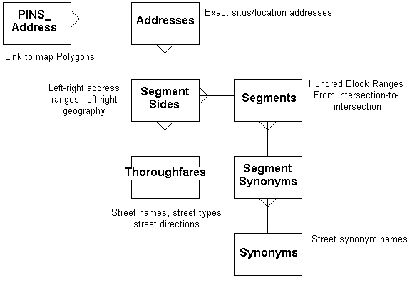
System's Model
In a coordinated GIS/911 data structure, key address range and exact address information are stored in an integral data model.Exact addresses can not be stored unless they "fit into" the address ranges and agree with the street name, street type and street direction of abutting street segments.The "single line" street map/database, in a GIS environment consists of both map vectors, i.e.graphics, and database attributes, i.e.address ranges, stored and maintained in a consistent fashion.The graphics add so much to the ability to store good attribute data! This data model also supports the likely precedence of the maintenance of key features, i.e.street names are normally approved, address ranges known--prior to the assignment of individual addresses and the issuance of building permits.This precedence will also do much to ensure that addressing systems are maintained with consistency and future growth in mind.Nothing is worse than assigning addresses only to find that neighboring addresses are now "out of sequence".
The following figure summarizes the data model for key address/geographic entities.
Subset Data Model for Addressing Entities
Chester County GIS/911
Figure 3
This early focus on address ranges as they pertain to new subdivisions also takes advantage of the GIS facilities to manage the addressing system and the address grids.The house numbering increment, ex.four even (or odd numbers) per 40 feet of street frontage as well as the North/South-East/West orientation of each proposed street can also be more easily determined by the GIS's maps and records.The GIS can help maintain the "system" of addresses to ensure uniqueness with each address assignment and over time.This is particularly important where addressing grids and street layouts do not parallel the cardinal directions, like in the original thirteen colonies.
The coordinate base of GIS will become that much more critical as 911 efforts shift toward wireless 911 location identification.In some locales, 911 calls received from cellular telephones are approaching 40+%.Coordinate verification, and subsequent dispatching of the closest emergency unit along the most direct path to the incident location will also benefit from improved 911/GIS linkage.The X-Y coordinate in space still does very little to locate the nearest available unit, direct that unit to the scene and provide the best information concerning access, ingress and egress to the emergency scene.
Even for current E-911 activities, the coordinate, graphic base of the GIS allows for the accurate cross-referencing between X-Y coordinates and the map vectors and individual addresses, intersections or address ranges.The GIS provides for the perfect marriage of address data and related X-Y coordinates maintained in sequence.Try that in your CAD package!
GIS/911 data integration will also improve the collection and linkage of telephone numbers at larger sites and complexes.Identification of the building entrance or the security office, etc.may do little to speed help to the proper, exact location.Campus, hospital, even office park complexes where Centrex or other private systems serve many local users help obscure the true location of a caller in need.GIS will play an increasing role with the proper 3-D orientation of land parcels, buildings and occupancies/suites, apartments and rooms[3].
Summary and Conclusions
This discussion may be stating the obvious, yet in most locales little GIS/911 integration exists or has even been attempted.While there is no question that a solid address base is absolutely essential for 911 functions, we are now realizing that addresses are essential for so many more functions of government. Good addresses, stored and maintained in an open, modern IT environment can support virtually all governmental functions.
For this integration to be successful, all update processing must be accomplished in a timely and accurate manner.No delays of a week or month can be tolerated where emergency dispatch is supported.This timeliness is a critical issue for many GIS implementations.For GIS/911 integration to work, all key map and address records must be maintained in a real-time, day-by-day manner.All of these daily uses also support the maintenance of an address database outside the narrow confines of emergency dispatch.If we catch address problems in a non-emergency context, we can clean-up the addresses before they are needed on a Saturday evening at mid-night in a snowstorm!
Glossary
Ascending Sequence of Addresses--one of the key addressing "rules".Numbers increase the further away from the address grid origin.
Address Parity--another "rule" of addressing.Normally even address numbers appear on one side of the street and odd addresses on the other side, not normally mixed.
CLEC (Competitive Local Exchange Carrier)--local telephone competition that came with deregulation.
Hundred Block Range--a lesser "rule" of addressing.With each intersection comes a new hundred block.Depending on address rules and local system, may not be used.
MSAG (Master Street Address Guide) File--basic geography/address range file hosted by the local Telephone Company, used to determine basic call switching to proper dispatch center for dispatching.
Bibliography
Eichelberger, F.Peirce, 1993 "The Importance of Addresses--The Locus of GIS", Urban and Regional Information Systems Association (URISA), Volume I, Annual Conference Proceedings.
Eichelberger, F.Peirce, 1998, "3D GIS: The Necessary Next Wave", Geo Info Systems, October, pp.30-33.
United States Bureau of the Census, Geography Division, Guidelines to Update the TIGER/Line a Files.
Published with permission of URISA
[1]Eichelberger, 1993.
[2]U.S.Bureau of the Census,
[3]Eichelberger, 1998.