Substantial advances over the last few years have
provided us with diverse and robust techniques to quickly and precisely
capture large amounts of geospatial information, extending traditional
surveying and photogrammetric solutions. For example, using cameras,
laser scanners and GPS sensors on-board static or mobile platforms
allows us to collect geospatially rich information, such as the
locations of moving objects, or detailed 3-D terrain models as they are
captured by an unmanned aerial vehicle flying over an area of interest.
While these current capabilities are indeed substantial, the future is
very exciting, as we are now on the verge of another significant
evolution: the emergence of geosensor networks.
While past advancements in
geospatial applications have been primarily
the result of efforts in closely related fields (e.g. optics, image
processing), this one is fueled by advancements in the field of
nanotechnology, and their effects on the emergence of sensor
networks. The advent of nanotechnology has made it both feasible
and economically viable to develop and deploy low-cost, low-power
semi-autonomous sensor devices that are general-purpose computing
platforms with multi-purpose on-board sensing and wireless
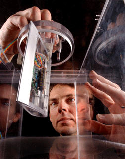
communication capabilities. For example, Sandia
Labs’ SnifferSTAR
(pictured above) is an ultra light (half-ounce) device that is
comprised of numerous tiny sensors on a platform about the size of a
pat of butter, atop a microprocessor board smaller than a credit card.
Deployed onboard a drone aircraft, it can detect biological and
radiological threats.
In sensor networks the objective is to get many such devices to collaborate and monitor specific phenomena. Each device then becomes a node of the network. The challenge is to aggregate sensor nodes into computational infrastructures that are able to produce globally meaningful information from raw local data obtained by individual sensor nodes: understanding for example that spikes in local measurements may correspond to a moving pollution front, and tracking its evolution.
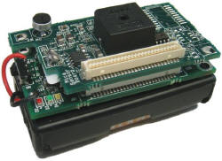
Sensor networks often comprise heterogeneous types of sensors, with various levels of capturing, processing and communication capabilities, hierarchically deployed to monitor a specific phenomenon [Hill et al., 2004]. At the lower end of processing capabilities we have generic dedicated tiny sensors. They typically range in size from few mm3 to few cm3 and have low communication capabilities (e.g. below 100Kbps). Mica2 is a representative example of such a sensor platform (Fig. 2). It is not uncommon for hundreds of such sensors to participate in a larger network. At higher levels of processing capabilities we may have high-bandwidth devices like cameras, with high, localized processing power, and communication capabilities in excess of 500Kbps (e.g. bluetooth). Beyond that, the network typically also includes a limited number of gateway sensors (see e.g. Stargate Gateway), to store locally large amounts of information collected by the other sensors, and/or provide a web front-end to support data access from outside the network. Software support for such networks is typically provided wither by Linux, or by TinyOS, an open-source energy-efficient operating system that supports large-scale sensor networks.
This sensor net approach introduces a novel data collection scheme, with continuous feeds of data from distributed sensors, covering a broader area of interest. This emerging data collection scheme is introducing interesting research challenges related to information integration and the development of infrastructures for systems comprised of numerous sensor nodes. Sensors may act collaboratively within broader network configurations that range in scale from a few cameras monitoring traffic at an intersection to thousands of diverse nodes monitoring a complex ecosystem.
Emerging sensor network applications are rather diverse in terms of their focus. For example, environmental applications include the use of sensor feeds to monitor drinking water quality [Ailamaki et al., 2003] and wildlife habitat monitoring in the ZebraNet Wildlife Tracking project [Juang et al., 2002; Mainwaring et al., 2002]. In construction there are applications for vehicle [Pister et al., 2002] and structure monitoring [Lin et al., 2002]. Another example is the use of sensor networks in smart space. These are typically rooms or even complete buildings with embedded sensing and computing capabilities that offer better interaction with humans by, for example, monitoring and altering conditions like temperature and lighting. A relevant example is the smart kindergarten project [Chen et al., 2002].
Geosensor networks are a specific type of sensor net. They can be loosely defined as sensor networks that monitor phenomena in geographic space, and in which the geospatial content of the information collected, aggregated, analyzed and monitored is of fundamental importance. In such networks, analysis and aggregation may be performed locally in real-time by the sensor nodes themselves, or off-line in several distributed, in-situ or centralized repositories. Regardless of where these processes take place, the spatial aspect is dominant in one or both of the following levels:
You could argue that the use of sensor networks for geospatial applications is not really new. Satellites and aerial cameras have been providing periodic coverage of the earth during the last few decades. However, in modern geosensor networks the old paradigm of calibrated sensors collecting information in highly-controlled deployment strategies is now replaced by wireless networks of diverse sensors. This evolution has a profound effect on the nature of collected datasets.
An international workshop addressing the emergence of GeoSensor Networks was held in 2003, and a post-workshop edited volume of proceedings has been published [Stefanidis & Nittel, 2004]. A second workshop on this topic is planned to be held in Boston, MA, in September, 2006. For additional information you may contact the author of this article.
References
Ailamaki A., C. Faloutsos, P. Fischbeck, M. Small, and J. VanBriesen, 2003. An Environmental Sensor Network to Determine Drinking Water Quality and Security, SIGMOD Record, 32(4), pp. 47-52.
Chen A., R. Muntz, S. Yuen, I. Locher, S. Park, and M. Srivastava, 2002. A Support Infrastructure for the Smart Kindergarten, IEEE Pervasive Computing, 1(2), pp. 49-57.
Juang P., H. Oki, Y. Wang, M. Martonosi, L. Peh, and D. Rubenstein, 2002. Energy-Efficient Computing for Wildlife Tracking: Design Tradeoffs and Early Experiences with ZebraNet, in Proc. Intl. Conf. On Architectural Support for Programming Languages and Operating Systems (ASPLOS-X), San Jose, CA, pp. 96-107.
Lin C., C. Federspiel, and D.M. Auslander, 2002. Multi-Sensor Single Actuator Control of HVAC Systems, in Proc. Intl. Conf. For Enhanced Building Operations, Austin, TX.
Mainwaring A., J. Polastre, R. Szewczyk, and D. Culler, 2002. Wireless Sensor Networks for Habitat Monitoring, Technical Report IRB-TR-02-006, Intel Laboratory, UC Berkeley.
Pister K. et al., 2002. 29 Palms Fixed/Mobile Experiment, robotics.eecs.Berkeley.edu/~pister/29Palms0103/.
Stefanidis A. and S. Nittel (Editors), 2004. GeoSensor Networks, CRC Press, Boca Raton, FL (296 pages).
 |
In sensor networks the objective is to get many such devices to collaborate and monitor specific phenomena. Each device then becomes a node of the network. The challenge is to aggregate sensor nodes into computational infrastructures that are able to produce globally meaningful information from raw local data obtained by individual sensor nodes: understanding for example that spikes in local measurements may correspond to a moving pollution front, and tracking its evolution.
Sensor networks often comprise heterogeneous types of sensors, with various levels of capturing, processing and communication capabilities, hierarchically deployed to monitor a specific phenomenon [Hill et al., 2004]. At the lower end of processing capabilities we have generic dedicated tiny sensors. They typically range in size from few mm3 to few cm3 and have low communication capabilities (e.g. below 100Kbps). Mica2 is a representative example of such a sensor platform (Fig. 2). It is not uncommon for hundreds of such sensors to participate in a larger network. At higher levels of processing capabilities we may have high-bandwidth devices like cameras, with high, localized processing power, and communication capabilities in excess of 500Kbps (e.g. bluetooth). Beyond that, the network typically also includes a limited number of gateway sensors (see e.g. Stargate Gateway), to store locally large amounts of information collected by the other sensors, and/or provide a web front-end to support data access from outside the network. Software support for such networks is typically provided wither by Linux, or by TinyOS, an open-source energy-efficient operating system that supports large-scale sensor networks.
 |
This sensor net approach introduces a novel data collection scheme, with continuous feeds of data from distributed sensors, covering a broader area of interest. This emerging data collection scheme is introducing interesting research challenges related to information integration and the development of infrastructures for systems comprised of numerous sensor nodes. Sensors may act collaboratively within broader network configurations that range in scale from a few cameras monitoring traffic at an intersection to thousands of diverse nodes monitoring a complex ecosystem.
Emerging sensor network applications are rather diverse in terms of their focus. For example, environmental applications include the use of sensor feeds to monitor drinking water quality [Ailamaki et al., 2003] and wildlife habitat monitoring in the ZebraNet Wildlife Tracking project [Juang et al., 2002; Mainwaring et al., 2002]. In construction there are applications for vehicle [Pister et al., 2002] and structure monitoring [Lin et al., 2002]. Another example is the use of sensor networks in smart space. These are typically rooms or even complete buildings with embedded sensing and computing capabilities that offer better interaction with humans by, for example, monitoring and altering conditions like temperature and lighting. A relevant example is the smart kindergarten project [Chen et al., 2002].
Geosensor networks are a specific type of sensor net. They can be loosely defined as sensor networks that monitor phenomena in geographic space, and in which the geospatial content of the information collected, aggregated, analyzed and monitored is of fundamental importance. In such networks, analysis and aggregation may be performed locally in real-time by the sensor nodes themselves, or off-line in several distributed, in-situ or centralized repositories. Regardless of where these processes take place, the spatial aspect is dominant in one or both of the following levels:
- Content level, as it may be the dominant content of the information collected by the sensors (e.g. sensors recording the movement or deformation of objects), or
- Analysis level, as the spatial distribution of sensors may provide the integrative layer to support the analysis of the collected information (e.g. analyzing the spatial distribution of chemical leak feeds to determine the extent and source of a contamination).
You could argue that the use of sensor networks for geospatial applications is not really new. Satellites and aerial cameras have been providing periodic coverage of the earth during the last few decades. However, in modern geosensor networks the old paradigm of calibrated sensors collecting information in highly-controlled deployment strategies is now replaced by wireless networks of diverse sensors. This evolution has a profound effect on the nature of collected datasets.
- Homogeneous collections of data (e.g. collections of standard format imagery and GIS layers) are now replaced by heterogeneous feeds for an area of interest (e.g. video and temperature feeds).
- Regularly sampled datasets (e.g. coordinates of similar accuracy in a regular grid) are replaced by pieces of information that vary substantially in content, resolution and accuracy (e.g. feeds from few, distinct, irregularly distributed locations captured by sensors of varying accuracy).
- Information becomes increasingly spatiotemporal instead of just spatial, as sensor feeds capture the evolution over time of the properties they monitor.
An international workshop addressing the emergence of GeoSensor Networks was held in 2003, and a post-workshop edited volume of proceedings has been published [Stefanidis & Nittel, 2004]. A second workshop on this topic is planned to be held in Boston, MA, in September, 2006. For additional information you may contact the author of this article.
 |
 |
References
Ailamaki A., C. Faloutsos, P. Fischbeck, M. Small, and J. VanBriesen, 2003. An Environmental Sensor Network to Determine Drinking Water Quality and Security, SIGMOD Record, 32(4), pp. 47-52.
Chen A., R. Muntz, S. Yuen, I. Locher, S. Park, and M. Srivastava, 2002. A Support Infrastructure for the Smart Kindergarten, IEEE Pervasive Computing, 1(2), pp. 49-57.
Juang P., H. Oki, Y. Wang, M. Martonosi, L. Peh, and D. Rubenstein, 2002. Energy-Efficient Computing for Wildlife Tracking: Design Tradeoffs and Early Experiences with ZebraNet, in Proc. Intl. Conf. On Architectural Support for Programming Languages and Operating Systems (ASPLOS-X), San Jose, CA, pp. 96-107.
Lin C., C. Federspiel, and D.M. Auslander, 2002. Multi-Sensor Single Actuator Control of HVAC Systems, in Proc. Intl. Conf. For Enhanced Building Operations, Austin, TX.
Mainwaring A., J. Polastre, R. Szewczyk, and D. Culler, 2002. Wireless Sensor Networks for Habitat Monitoring, Technical Report IRB-TR-02-006, Intel Laboratory, UC Berkeley.
Pister K. et al., 2002. 29 Palms Fixed/Mobile Experiment, robotics.eecs.Berkeley.edu/~pister/29Palms0103/.
Stefanidis A. and S. Nittel (Editors), 2004. GeoSensor Networks, CRC Press, Boca Raton, FL (296 pages).
From Our Homepage
Saying Farewell to an Amazing Journey
Communicating with Maps
Is There a GIS Career Ladder?
What does it mean to be geospatially smart? Series
Ways Real Estate and Property Developers Utilize Melissa GeoData for Data-Driven Decisions
Unlocking Value From Daily Satellite Imagery and Insights
Maximizing the Value of Your Address Data with Geo Addressing
How Indoor Mapping Enhances the Security of Smart Buildings
Look Ahead: AI, Location Intelligence and Efficiency
Collaboration Takes on Sea Level Rise & Dynamic Technology Environments
Brownies for Brownfields
Has Everything Been Mapped Already?
How Is Data Literacy Changing in an Artificial Intelligence Landscape
Portfolios for GIS Professionals: More Than Just Maps
How to Create a Distance Matrix in QGIS - A Step-by-Step Guide
7 Ideas for Bringing GIS into the K-12 Classroom
The Geography of Movement