How do organizations and individuals measure the value
of investments in geospatial data? Or investments in geospatial
technologies? How do you make the case for geospatial information as
part of the core information infrastructure of an organization, or
embedding geospatial information in your enterprise applications? While
the technical justification for these investments are often clear to
those making them, GIS administrators often wrestle with how to
meaningfully quantify the anticipated benefits, and realistically state
the costs, to constituents and policy makers.Traditional methods like
cost-benefit analyses, with their emphases on financial
return-on-investment, fall short at measuring the less tangible,
knowledge-related assets, particularly in non-commercial and
governmental environments.Another set of tools that adequately
describe the multidimensional decision environment is needed to guide
the decision process.
Previous articles (1, 2, 3 and 4) have outlined and described the elements of the Location Aware Enterprise and showcased efforts by the State of Mississippi to enable location awareness for their statewide enterprise.These five services elements are:
The Value Measuring Methodology (VMM) is a cost-benefit analysis tool designed to capture the dimensions that are hard to quantify in a traditional financial return-on-investment study.VMM was originally developed by Booz Allen Hamilton and academics affiliated with Harvard University's Kennedy School of Government under contract with Social Security Administration and the General Services Administration.The VMM assesses costs, benefits and risks for five major stakeholder groups:
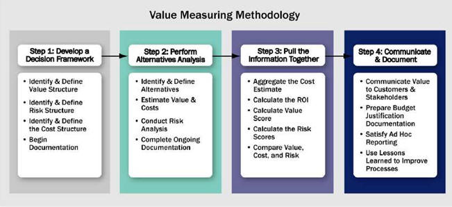
Step 1: Develop a decision framework
The cornerstone of VMM is an objective and impartial decision framework.Made up of three structures - value, cost and risk - this framework provides decision makers with a blueprint for defining, analyzing and evaluating decisions.It also ensures that decision makers will have the level of information necessary to justify investments in geospatial information.This step creates the overall framework, establishes the objectives and creates global assumptions in which the analysis will be structured.
Step 2: Perform alternatives analysis
Once an objective decision framework has been developed, the various technical alternatives can easily be compared.VMM's strength lies in its ability to compare alternatives that have widely different costs, values and risks.The decision framework created in Step I is used to compare these alternatives on various customer defined criteria. Additionally, estimating the costs and projecting the value must, to the greatest extent possible, predict actual costs and value.Estimates are derived from ranges that define specific elements of cost and measures of performance and then are subjected to an uncertainty analysis to develop a range of expected value.This uncertainty is defined by the risks each alternative presents.
Step 3: Pull together the information
With a complete value, cost and risk analysis in hand, financial measures are calculated and value, cost and risk scores are calculated. Alternatives are then compared to determine the business practice that provides the most benefits.The conclusion developed at this stage is dependent on the completeness and quality of planning and analysis in the prior steps.
Step 4: Communicate and document
The outputs of VMM are then used to communicate the overall value of an initiative to stakeholders.The planning and analysis required by VMM produce artifacts and documents that can be used to audit the decision process.The outputs can be used to support different technical alternatives or policy positions.
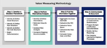
The VMM framework.Source: Booz Allen Hamilton.Click for larger view.
Examples of practical applications of the VMM include a
recent study in support of the federal government's electronic
government initiative on the XML.gov registry.The problem was that
many agencies were creating their own registries in isolation, leading
to redundant expenditures of taxpayer dollars and operational
inefficiencies, due to the lack of interoperability.The VMM was used
to assess the costs and benefits of three alternatives, which consisted
of the base case (or status quo), moving toward a federated registry,
or moving to a centralized registry.Expected benefits were calculated
for each of the five groups, then aggregated to arrive at a total
benefit score.Then, each case was adjusted for risk to arrive at a
risk-adjusted score.The scores for each of the three cases could then
be easily compared.Moreover, each score could be analyzed to see where
the greatest risks occurred, which groups benefited most, and where the
costs would occur.This provided the clients with insights that only a
multidimensional analysis can provide.
It is a short leap to the analogous geospatial case, where similar decisions need to be made about the information infrastructure.By highlighting the links between value, risk and cost, agencies and individuals can understand and make decisions about investments in geospatial technologies and information.Understanding these linkages is increasingly important as geospatial information gradually becomes a key piece of business information.As more agencies take an enterprise approach to information technologies, the VMM can be used to support enterprise architecture planning decisions, including the integration of geospatial information.
Finally, the VMM is a useful compliment to the organizational design and change management processes.Used in the planning stages, VMM studies can identify which stakeholders are likely to benefit from different alternatives, can surface risks to those stakeholders and help identify capability gaps in the organization.The VMM can also help identify early wins for the transformation process and help set implementation priorities.VMM metrics reinforce the organizational change process by providing a multi-dimensional picture of benefits (time, groups, alternatives) of different investment scenarios.
To summarize, over the course of five articles the concept of a Location Aware Enterprise has been introduced, what it is and why it is important, through examples from New York City during 9/11, to the State of Mississippi, and addresses the non-technical, but highly important aspects of organizational design and change management, and economic business analysis.As the Location Technology and Business Intelligence Conference approaches, attendees will hear more about tools for informing business operations using location information and integrating multiple workflows and disparate databases across the enterprise.At the conference, case studies will be presented about how this has been done, and many technology demonstrations will show how technology enables business operations. The Location Aware Enterprise provides a roadmap for matching business needs with the art of the possible in technology, and ties it all together, maximizing investments in location technologies for business intelligence.
Previous articles (1, 2, 3 and 4) have outlined and described the elements of the Location Aware Enterprise and showcased efforts by the State of Mississippi to enable location awareness for their statewide enterprise.These five services elements are:
- Organizational design and change management
- Enterprise architecture
- Information architecture and knowledge management
- Analysis and visualization
- Economic business analysis
The Value Measuring Methodology (VMM) is a cost-benefit analysis tool designed to capture the dimensions that are hard to quantify in a traditional financial return-on-investment study.VMM was originally developed by Booz Allen Hamilton and academics affiliated with Harvard University's Kennedy School of Government under contract with Social Security Administration and the General Services Administration.The VMM assesses costs, benefits and risks for five major stakeholder groups:
- Direct User
- Government Financial
- Government Operational / Foundational
- Social
- Political / Strategic
Step 1: Develop a decision framework
The cornerstone of VMM is an objective and impartial decision framework.Made up of three structures - value, cost and risk - this framework provides decision makers with a blueprint for defining, analyzing and evaluating decisions.It also ensures that decision makers will have the level of information necessary to justify investments in geospatial information.This step creates the overall framework, establishes the objectives and creates global assumptions in which the analysis will be structured.
Step 2: Perform alternatives analysis
Once an objective decision framework has been developed, the various technical alternatives can easily be compared.VMM's strength lies in its ability to compare alternatives that have widely different costs, values and risks.The decision framework created in Step I is used to compare these alternatives on various customer defined criteria. Additionally, estimating the costs and projecting the value must, to the greatest extent possible, predict actual costs and value.Estimates are derived from ranges that define specific elements of cost and measures of performance and then are subjected to an uncertainty analysis to develop a range of expected value.This uncertainty is defined by the risks each alternative presents.
Step 3: Pull together the information
With a complete value, cost and risk analysis in hand, financial measures are calculated and value, cost and risk scores are calculated. Alternatives are then compared to determine the business practice that provides the most benefits.The conclusion developed at this stage is dependent on the completeness and quality of planning and analysis in the prior steps.
Step 4: Communicate and document
The outputs of VMM are then used to communicate the overall value of an initiative to stakeholders.The planning and analysis required by VMM produce artifacts and documents that can be used to audit the decision process.The outputs can be used to support different technical alternatives or policy positions.
The VMM framework.Source: Booz Allen Hamilton.Click for larger view.
It is a short leap to the analogous geospatial case, where similar decisions need to be made about the information infrastructure.By highlighting the links between value, risk and cost, agencies and individuals can understand and make decisions about investments in geospatial technologies and information.Understanding these linkages is increasingly important as geospatial information gradually becomes a key piece of business information.As more agencies take an enterprise approach to information technologies, the VMM can be used to support enterprise architecture planning decisions, including the integration of geospatial information.
Finally, the VMM is a useful compliment to the organizational design and change management processes.Used in the planning stages, VMM studies can identify which stakeholders are likely to benefit from different alternatives, can surface risks to those stakeholders and help identify capability gaps in the organization.The VMM can also help identify early wins for the transformation process and help set implementation priorities.VMM metrics reinforce the organizational change process by providing a multi-dimensional picture of benefits (time, groups, alternatives) of different investment scenarios.
To summarize, over the course of five articles the concept of a Location Aware Enterprise has been introduced, what it is and why it is important, through examples from New York City during 9/11, to the State of Mississippi, and addresses the non-technical, but highly important aspects of organizational design and change management, and economic business analysis.As the Location Technology and Business Intelligence Conference approaches, attendees will hear more about tools for informing business operations using location information and integrating multiple workflows and disparate databases across the enterprise.At the conference, case studies will be presented about how this has been done, and many technology demonstrations will show how technology enables business operations. The Location Aware Enterprise provides a roadmap for matching business needs with the art of the possible in technology, and ties it all together, maximizing investments in location technologies for business intelligence.
From Our Homepage
Saying Farewell to an Amazing Journey
Communicating with Maps
Is There a GIS Career Ladder?
What does it mean to be geospatially smart? Series
Ways Real Estate and Property Developers Utilize Melissa GeoData for Data-Driven Decisions
Unlocking Value From Daily Satellite Imagery and Insights
Maximizing the Value of Your Address Data with Geo Addressing
How Indoor Mapping Enhances the Security of Smart Buildings
Look Ahead: AI, Location Intelligence and Efficiency
Collaboration Takes on Sea Level Rise & Dynamic Technology Environments
Brownies for Brownfields
Has Everything Been Mapped Already?
How Is Data Literacy Changing in an Artificial Intelligence Landscape
Portfolios for GIS Professionals: More Than Just Maps
How to Create a Distance Matrix in QGIS - A Step-by-Step Guide
7 Ideas for Bringing GIS into the K-12 Classroom
The Geography of Movement