Ed.Note: Steve Lombardi,
our
favorite guy-who-wears-a-lot-of-black, is back for his second year of
commentary on the Directions Magazine Web Mapping Contest, offering
Oscars in
categories ranging from Best Raster Imagery to Least Nerdy ...
 I'm glad to
be invited back for the judging of the second annual Oscars of Web
Mapping.Any
excuse to get the tux back out of the closet again.For those of you
that
weren't with us last
year,
the Web Mapping Oscars are a second chance for entrants in Directions
Magazine's online mapping contest to shine after the
official awards have been voted on by the readers.And like last year,
there
are no fancy prizes to be had here.Just the honor, or dishonor in some
cases,
of being singled out among your peers for building a web app that
stands out in
some way.Some of your old favorite categories are back, and a few new
ones get
introduced this year.The first envelope please...
I'm glad to
be invited back for the judging of the second annual Oscars of Web
Mapping.Any
excuse to get the tux back out of the closet again.For those of you
that
weren't with us last
year,
the Web Mapping Oscars are a second chance for entrants in Directions
Magazine's online mapping contest to shine after the
official awards have been voted on by the readers.And like last year,
there
are no fancy prizes to be had here.Just the honor, or dishonor in some
cases,
of being singled out among your peers for building a web app that
stands out in
some way.Some of your old favorite categories are back, and a few new
ones get
introduced this year.The first envelope please...
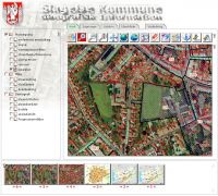 |
Nicest User Interface Slagelse Geographic Information Planner Never has land use management looked so polished! A nice toolbar, simple layer control and easy to discover functionality add up to create a great user experience. And the killer feature is the implementation of the history thumbnails below the map - each of your previous map views is at the ready in a scrollable pane of thumbnails.Hover over one of them to get a preview, and click to reinstate it as the active map! This is a strong application across the board and could have easily won in a number of categories.I imagine that if I could speak the language I would unearth some other gems here as well. |
 |
Best Raster Imagery
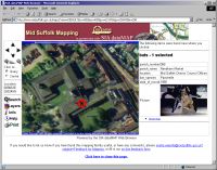
Application Mid Suffolk District Council GIS Browser While I have a number of nits to pick regarding the UI here (lack of legend for the layers turned on, really ugly buttons, lack of an option for a bigger map...) this app had a lot of charm; as much charm as a YALM (yet another land management) application can have.The aerial imagery was effective providing a backdrop for the other layers that could be added, and registered well with the overlayed data.In addition to the layers expected in any good YALM, this app features bat and newt coverage.Yes, you can actually use this application to help hunt down that final ingredient for the witch's brew you may be concocting.I had no idea this was such a problem in Suffolk. |
 |
Least Nerdy Application Looking for the best vineyards wine tasting locations? WHEW! Finally.After pouring through 84 applications for land management, water runoff analysis, remote sensing and other hardcore GIS utility, at last a truly useful application to help me get my drunk on! Warning: Use responsibly.Should not be used in conjunction with the Montana Hunting Guide. |
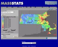 |
Best Web-based Thematic
Mapping MassStats.com Massachusetts Data Warehouse Good thematic analysis can be complex, especially in a web interface.This Maptitude powered application does a nice job of making it simple for the user, in spite of (or perhaps due to) its rather spartan, no frills interface.Lots of data at your fingertips in a variety of categories from crime to economics at the county level, and upon zooming in, at the zipcode level.Unfortunately performance was slow and often when I went to use the application it would break with server side processing errors, highlighting a problem I found in a number of applications - scalability and reliability need to be considered before bells and whistles. |
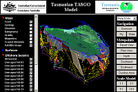 |
Best Eye Candy 3D Geology of Tasmania I really have no idea what's going on here, but it's a lot of fun to play with and looks really cool.Not to mention that Tasmania is one of those remote places on earth I'd like to visit someday.Before trying this, make sure you have the Blaxxun Contact VRML plugin installed, then take off.It's easy to get disoriented, especially after adding a number of layers, but judicious use of the 'reset view' button will straighten you out.Looks like a lot of work went into this; I hope real professional geologists actually get some use out of it. |
 |
Most Environmentally
Friendly Northern Ireland Interactive Wind Mapping Looking out my window here at Microsoft, I'm often convinced there must be a monster truck rally going on somewhere on campus that I don't know about. Jacked up pickups, Hummers wider than the roads themselves, and SUV's whose greatest challenge is tearing up the mall parking lot speed bumps, parade around with a twisted sense of pride.So refreshing to then see someone using GIS for such a noble purpose.Featuring elevation and wind speed data, this app will help you find the perfect ground to plant your windfarm.And it's very easy to use and navigate.Rock on. |
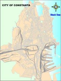 |
Biggest Overachiever City of Constanta By the developer's own modest admission, this application is "a free, plain GIS, with minimum information about features seen on map." With expectation set low, I jumped in.This isn't bad at all, featuring a dynamic legend, active overview map, info tool, and good navigation.Under promise and overdeliver. This one is also a runner up in the 'bang for the buck' category. |
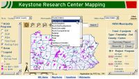 |
Most Bang for the Buck Keystone Research Map I have a lot of respect for developers who can take php, some dental floss, Microsoft Access and some cartography found online and cob together a useable application.There were a bunch of applications in this year's contest that fit this description - not always pretty, often barely useable, but always under budget (assuming there even was a budget).This Frankenmap combines a lot of features and functionality with a decent UI, delivering an overall experience that is at least on par with many of the pricier entrants. |
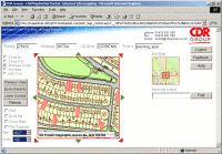 |
Home Grown Map Renderer Browse-A-Map Just when you thought the days of the do it yourself map renderer were gone, comes Browse-A-Map.Locked up tighter than the missing ballots in Ohio, this application is protected with actual steel cages and guard dogs. Seriously, I'm not sure why there are so many layers of protection to just browse generic public map data, but there are.Why is my phone number required for access? Was emailing me a validation code really necessary? After jumping through the requisite hoops, you meet a surprisingly quick and versatile map renderer built on .NET that can deal with MapInfo and ESRI formatted data and handles raster imagery in TIFF or JPG format.From their website, it is not clear if this is a commercially available tool, or for their internal use only, but I think it has a lot of promise. |
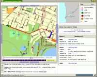 |
Best Multimode Transport Interactive Maps for the Transperth Journey Planner This isn't even a category.I just made it up, and I'm pretty sure this is the only application of the 85 submissions that would even qualify.But I had to figure out a way to give props to this app.The mapping isn't spectacular, but it solves a difficult problem really well.How do I get from point A to point B, given the range of public transportation I have at my disposal.The wizard-like UI allows you to enter your stops, correct them, and choose your modes of transport.The resulting itineraries break out your time walking, on the train, etc...and include timetables and maps.Slick.Unfortunately and ironically given the nature of this contest, it is the actual street map presentation that is the weakest link.Hey, I know where these guys can get some really nice street maps for Australia in a really cost effective Web service... |
From Our Homepage
Saying Farewell to an Amazing Journey
Communicating with Maps
Is There a GIS Career Ladder?
What does it mean to be geospatially smart? Series
Ways Real Estate and Property Developers Utilize Melissa GeoData for Data-Driven Decisions
Unlocking Value From Daily Satellite Imagery and Insights
Maximizing the Value of Your Address Data with Geo Addressing
How Indoor Mapping Enhances the Security of Smart Buildings
Look Ahead: AI, Location Intelligence and Efficiency
Collaboration Takes on Sea Level Rise & Dynamic Technology Environments
Brownies for Brownfields
Has Everything Been Mapped Already?
How Is Data Literacy Changing in an Artificial Intelligence Landscape
Portfolios for GIS Professionals: More Than Just Maps
How to Create a Distance Matrix in QGIS - A Step-by-Step Guide
7 Ideas for Bringing GIS into the K-12 Classroom
The Geography of Movement