"Have you used it much?" I inquired.
"It has never been spread out, yet," said Mein Herr: "the farmers objected: they said it would cover the whole country, and shut out the sunlight! So we now use the country itself, as its own map, and I assure you it does nearly as well."
While Great Britain's Ordnance Survey (OS) doesn't produce maps at a scale of 1:1 quite yet, its Landline series offers maps at a resolution of 1:1250, allowing the display of individual buildings, which is very useful to those requiring detailed mapping, such as architects, telecommunication engineers, and surveyors.
In addition to Landline, the OS produces a wide variety of maps and services, including more than 25 mapping products at various scales for professional, business, and leisure use, as well as a number of services, such as consulting, database development, surveying, mapping, and printing.
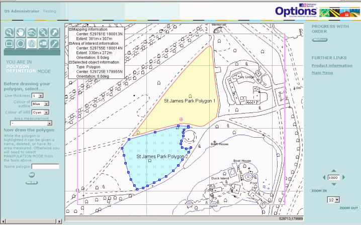
Creating polygons for area measurement on Landline data
A few years ago, the British government changed the official status of the OS to that of a 'Trading Fund,' giving it more responsibility for its own finances and planning and more freedom to develop new initiatives. The strategic importance of the OS has also been recognized by the government, allowing the agency to report directly to Parliament through the newly formed Office of the Deputy Prime Minister.
The British Ordnance Survey has been in existence since the time of the Napoleonic Wars when it quickly established itself as a leader in the field of cartography, due in part to the country's need to map its ever-expanding empire.
The OS was an early adopter of GIS, implementing its original system more than 30 years ago. While this allowed them to take advantage of the benefits of automated mapping for many years, it also resulted in a number of incompatible systems and databases because department GIS implementation was generally ad hoc and project driven.
Comments Ed Parsons, Chief Technology Officer for the Ordnance Survey,
"When I arrived at the OS about a year ago, we started the process of completely
re-engineering our back-end infrastructure because of the compatibility
issues. That coincided with the release of MasterMap™, our new and
very detailed topographic mapping product."
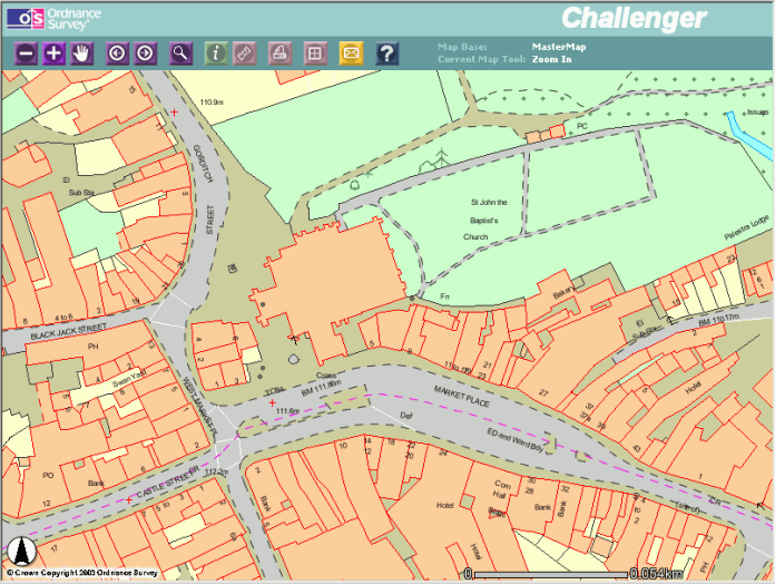
OS MasterMap™ viewed using the Challenger system
The MasterMap™ series includes highly detailed maps of England, Scotland,
and Wales at 1:1,250 for urban and suburban regions and 1:2,500 for rural
areas.
Parsons continues, "We have developed an object-based data set for
our new MasterMap™ series. In this database, every topographic feature
in the country has been identified, given its own unique identifier, and
stored as an object. The database is currently 600 gigabytes in size
and has more than 430 million features in it."
Because MasterMap™ is seamless; you can easily click on any object
in the geographic area that you are interested in for a display of that
particular area. You can also mix and match data for a particular
analysis. For example, you could specify major roads within a certain
distance of a particular river for an environmental impact study or include
the boundaries of urban areas to examine transportation issues.
The OS has more than 500 field surveyors around the country that record thousands of changes daily to accurately maintain this massive database. This rigorous revision schedule means that it is never more than 6 months out of date in any area of the country.
To collect and maintain the database, the OS is implementing the Field
Object Editor (FOE), which is largely build around ESRI's GIS software.
ArcGIS tools are on the client side and ArcSDE is used to manage the large
spatial datasets stored in an Oracle DBMS. Tadpole-Cartesia is the
prime contractor for the implementation of the project and is providing
a secure two-way web communication platform to share and interact on files
and data for the FOE system. The result is a tightly integrated COTS
solution, providing the agency with a large reduction in cost and a great
deal of flexibility in collecting data and expanding the system.
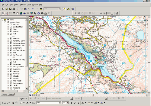
1:50,000 dataset viewed using ArcMap
Parsons indicates that a major benefit of FOE is that field employees will be able to version out some of the data for their work at the same time that someone back in the office is working on the same data. It will also allow the field workforce to be more mobile and ultimately connect from the field to the database via a wireless network.
Currently, the biggest customer of the OS is the Land Registry of the
United Kingdom, which is responsible for maintaining land title or ownership
records. However, Parsons believes that GIS is going to be used in
more of the policy-making government departments in the future to determine,
for example, the best area to apply economic grants to aid development.
"Government departments can start to make more use of our data because
it is now much more intelligent and it is possible to connect other information
to it," he adds.
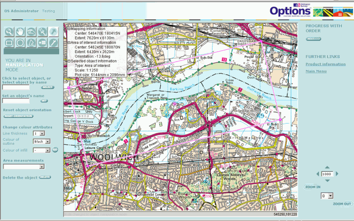
Customised Area of Interest on a Landranger backdrop
Parsons sees context as the key element of wireless Internet use in the future and believes that GIS and GPS can provide the essential geographic reference needed for embedded applications. This could allow a field surveyor to automatically receive local information on his PDA specific to his location.
"I think that in the future data and the relevant application, designed
specifically for your particular use, will be accessed from the network
just for that time that you need it and then discarded. I think that
this is the natural evolution of the GIS industry as data and services
become more intertwined," concluded Parsons.