The past few weeks have been particularly busy for
geospatial technology. It's been so busy, in fact, that I've not been
able to comment on everything that's been formally announced, or just
trickled out. In this editorial I want to do just that, in part to be
sure my thoughts are shared and in part to be sure these stories don't
slip through the cracks.
Apple and Core Location
Apple news (geospatial and otherwise) has been focused on the iPhone for the past year or so. But last week developers revealed some operating system news related to location. Developers working on a pre-release version of Mac OS X (10.6) called "Snow Leopard" noted the inclusion of the ability to use networking hardware to determine location. It's the same framework, called Core Location, that's found in the iPhone. Core Location is the API that allows software developers to access the location- aware features - be they from GPS, Wi-Fi or something else.
Apple's Snow Leopard Will Triangulate a Mac's Location
Word is that moving the technology from the iPhone to the OS X operating system is trivial since they're built on the same underlying platform. I see this as a firm step forward; I've suggested in the past that the further down in the stack we can push location, the easier it will be for developers to take advantage of it and the more it will be used.
New California Geospatial Coordination Website
California took a step in its quest toward leadership in geospatial in February when Natural Resources Agency Secretary Mike Chrisman and State Chief Information Officer Teri Takai announced the Cal-Atlas Geospatial Clearinghouse Website (press release). It's part catalog, part gallery and part coordination portal, and thus helps pull together previously disparate geospatial resources. Some in the blogging community have noted the elegance and accessibility of the site, but that the website has a limited amount of actual data available. The fact that this portal is acting as a "straw man" of sorts as we contemplate the NDSI is fabulous! I found the site's interface rather elegant and I especially like the option to list only datasets that are "linked," and thus hopefully available online, when "discovering" data. One (perhaps typo?) criticism: the 2007 copyright date.
API Bonanza
While there is much demand for data sharing itself, there are times when it's not practical from a business perspective. The good news? More software APIs that allow programmers to tap into valuable geospatial databases are popping up. Urban Mapping offers a free mass transit proximity API that taps into its database of "stops" (press release). HopStop has an API that allows developers access to its public transit directions (in the cities it serves) (All Points Blog). And, if you missed it, the New York Times now provides an API to all its content since 1981. The Web is getting more mashable all the time.
Google
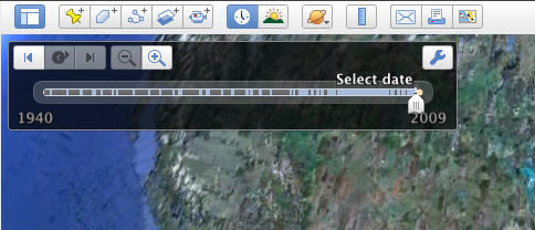
While much of the focus of the launch of Google Earth 5 last week was on the geography beneath the ocean, the big news for me in the latest iteration is the historical imagery. I'm excited about it for two main reasons. First, it means that the metadata for images in the database are somewhere and perhaps in time we end users will have more access to them. I've been lobbying for access to date-of-acquisition information for imagery for some time on all the mapping portals. Second, it means that more "non geo" people can explore what geospatial technologists do with imagery. One thing we do is to study change detection in natural resources, urban planning and other applications. And now, they can do a bit of it themselves! I look forward to hearing about how educators, in particular, are using this tool.
In related and perhaps overlooked news, Google asked for those with imagery (historical or otherwise) to share it via a new partner program. Will this work better than previous efforts by, say, the U.S. government? I'm aware of many localities that lower the burden on their own servers for imagery, especially, by having portals like Google's do the hosting for the public. The in-house servers are used for more GIS applications of imagery or data.
I'm confident few if any readers managed to escape the announcement of Google Latitude, the add-on for Google Maps that allows individuals on cell phones and PCs to share (or not) their location. I observed a few things about this announcement: The announcement was not addressed, in particular, to the geospatial community. All the traditional online tech sites got a preview and had the story before any of the geospatial bloggers. That reinforces the fact that Google presents its tech as general and for a general (consumer) audience, at least at the outset. That continues to be 100% different from the focused GIS technology companies.
As expected, the media went through the normal and expected stages of positioning the announcement. This seems to happen with just about every Google (and sometime non-Google) LBS announcement.
Apple and Core Location
Apple news (geospatial and otherwise) has been focused on the iPhone for the past year or so. But last week developers revealed some operating system news related to location. Developers working on a pre-release version of Mac OS X (10.6) called "Snow Leopard" noted the inclusion of the ability to use networking hardware to determine location. It's the same framework, called Core Location, that's found in the iPhone. Core Location is the API that allows software developers to access the location- aware features - be they from GPS, Wi-Fi or something else.
Apple's Snow Leopard Will Triangulate a Mac's Location
Word is that moving the technology from the iPhone to the OS X operating system is trivial since they're built on the same underlying platform. I see this as a firm step forward; I've suggested in the past that the further down in the stack we can push location, the easier it will be for developers to take advantage of it and the more it will be used.
New California Geospatial Coordination Website
California took a step in its quest toward leadership in geospatial in February when Natural Resources Agency Secretary Mike Chrisman and State Chief Information Officer Teri Takai announced the Cal-Atlas Geospatial Clearinghouse Website (press release). It's part catalog, part gallery and part coordination portal, and thus helps pull together previously disparate geospatial resources. Some in the blogging community have noted the elegance and accessibility of the site, but that the website has a limited amount of actual data available. The fact that this portal is acting as a "straw man" of sorts as we contemplate the NDSI is fabulous! I found the site's interface rather elegant and I especially like the option to list only datasets that are "linked," and thus hopefully available online, when "discovering" data. One (perhaps typo?) criticism: the 2007 copyright date.
 |
API Bonanza
While there is much demand for data sharing itself, there are times when it's not practical from a business perspective. The good news? More software APIs that allow programmers to tap into valuable geospatial databases are popping up. Urban Mapping offers a free mass transit proximity API that taps into its database of "stops" (press release). HopStop has an API that allows developers access to its public transit directions (in the cities it serves) (All Points Blog). And, if you missed it, the New York Times now provides an API to all its content since 1981. The Web is getting more mashable all the time.
While much of the focus of the launch of Google Earth 5 last week was on the geography beneath the ocean, the big news for me in the latest iteration is the historical imagery. I'm excited about it for two main reasons. First, it means that the metadata for images in the database are somewhere and perhaps in time we end users will have more access to them. I've been lobbying for access to date-of-acquisition information for imagery for some time on all the mapping portals. Second, it means that more "non geo" people can explore what geospatial technologists do with imagery. One thing we do is to study change detection in natural resources, urban planning and other applications. And now, they can do a bit of it themselves! I look forward to hearing about how educators, in particular, are using this tool.
 |
In related and perhaps overlooked news, Google asked for those with imagery (historical or otherwise) to share it via a new partner program. Will this work better than previous efforts by, say, the U.S. government? I'm aware of many localities that lower the burden on their own servers for imagery, especially, by having portals like Google's do the hosting for the public. The in-house servers are used for more GIS applications of imagery or data.
I'm confident few if any readers managed to escape the announcement of Google Latitude, the add-on for Google Maps that allows individuals on cell phones and PCs to share (or not) their location. I observed a few things about this announcement: The announcement was not addressed, in particular, to the geospatial community. All the traditional online tech sites got a preview and had the story before any of the geospatial bloggers. That reinforces the fact that Google presents its tech as general and for a general (consumer) audience, at least at the outset. That continues to be 100% different from the focused GIS technology companies.
As expected, the media went through the normal and expected stages of positioning the announcement. This seems to happen with just about every Google (and sometime non-Google) LBS announcement.
- statement of what it is (some used the terms "spy" or "track," some, the term "friendfinder")
- horror at privacy concerns
- realization that others already have such offerings
- conclusion that the app will be monetized by (location-based) advertising
From Our Homepage
Saying Farewell to an Amazing Journey
Communicating with Maps
Is There a GIS Career Ladder?
What does it mean to be geospatially smart? Series
Ways Real Estate and Property Developers Utilize Melissa GeoData for Data-Driven Decisions
Unlocking Value From Daily Satellite Imagery and Insights
Maximizing the Value of Your Address Data with Geo Addressing
How Indoor Mapping Enhances the Security of Smart Buildings
Look Ahead: AI, Location Intelligence and Efficiency
Collaboration Takes on Sea Level Rise & Dynamic Technology Environments
Brownies for Brownfields
Has Everything Been Mapped Already?
How Is Data Literacy Changing in an Artificial Intelligence Landscape
Portfolios for GIS Professionals: More Than Just Maps
How to Create a Distance Matrix in QGIS - A Step-by-Step Guide
7 Ideas for Bringing GIS into the K-12 Classroom
The Geography of Movement