Ed. note: This article originally appeared in
the November/December 2007 issue of Right of Way Magazine, and
is reprinted here with permission.
With the growing demands imposed on our transportation infrastructure, state and local transportation agencies require capable, efficient solutions to enable them to resolve problems and make informed decisions with confidence. To meet these needs, transportation administrators increasingly depend on the unmatched potential of GIS and their ability to organize, display and facilitate complete analysis of vast amounts of information. Having digital parcel maps available with detailed property information just a mouse click away opens up the door to a whole new way of managing right of way projects.
Observing this trend and seeking to take advantage of the opportunities in GIS integration, the Transportation Research Board (TRB) began examining its potential in the right of way process by involving a panel of experts to monitor the research of current and future possibilities. As a division of the National Research Council, the board’s mission is to promote innovation and progress in transportation through research. The independent advisory group focuses on all modes of transportation, and provides an objective and interdisciplinary setting where it initiates and manages research projects in order to share information on transportation policy and programs. With support at both the federal and state level, the board widely disseminates the research results, offering expert advice while promoting technical excellence.
Recently, I had the distinct pleasure of chairing a TRB project panel that focused its efforts on future progress, specifically working to identify the problems and challenges presented within the right of way sector, and providing research funding to address these problems. While the panel’s findings confirmed the enormously valuable role of GIS within the realm of transportation, the research has also shown that few organizations have been able to fully capitalize on the potential of GIS integration. Like many concepts and processes rooted in technology, progress is often met with the initial challenges of hardware and software changes, system-wide standardization, and a need for education and training. With the rising rate of retirement within the industry, the evaporating knowledge pool makes the need for increased understanding even more vital. In some instances, a general shortage of knowledge regarding GIS capabilities makes the task of integration seem more complex and can unfairly outweigh the immense value, usefulness and functionality available.
Several difficulties may stand between a transportation agency and its successful use of GIS technology, including:
WSDOT: Modernization of the Right of Way Management System
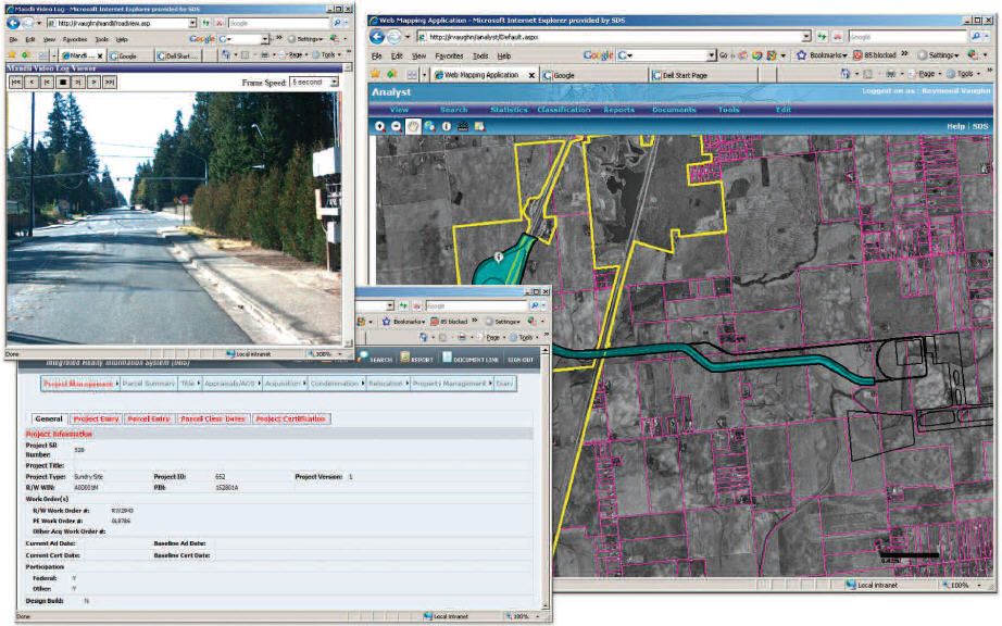
In reviewing their real estate services program, the Washington State Department of Transportation (WSDOT) identified a great need for a more modern and efficient right of way management system. Facing state and federal mandates, along with ever-increasing requests for information, WSDOT needed to improve their data integrity and
consolidate it into a well-organized system that would allow special reporting and ad hoc inquiries.
Previously, WSDOT was using an internally developed system, and as a result, did not benefit from any vendor support or program scalability. Their system lacked GIS integration and automated processes, and failed to provide timely information in a user-friendly format. With six regional offices and multiple remote offices all operating independently, inconsistency across the agency was becoming a major hurdle. In order to identify and document the current needs and obstacles, a Business Process Reengineering (BPR) phase was completed. The goal of the BPR was to assess the efficiency and effectiveness of the existing workflow processes and identify areas for improvement. By incorporating the BPR at this stage, the department and their vendors could look at the business processes from a “clean slate” perspective and determine how to best impact and improve how they conduct business.
The solution that best met WSDOT’s needs was a web-based system that
included project management, inventory and management of all real
estate transactions. The new system, known as the Integrated Realty
Information System (IRIS), standardizes the data and land acquisition
processes and integrates external systems for advanced management
workflow and reporting capabilities. This web-based system offered
real-time information with scheduling and asset reporting while also
providing project creation tools. Another key component was the
integration of IRIS with WSDOT’s financial management system, which
provides daily updates of their financial status for reporting and
management purposes.
As with many departments of transportation, the need for accessibility among a large base of users is essential. For WSDOT, this involved providing easy access for approximately 150 users across the state. It was obvious that a web-based platform was necessary to utilize the latest technologies while eliminating the complications of potential software updates in a multi-departmental system. With this increased accessibility, they were able to simplify the dissemination of guidelines and standard practices for all state agencies involved in the real estate activities.
In the next phase of the IRIS project, WSDOT will be evaluating the feasibility of GIS integration to further advance their capabilities. The addition of GIS will provide WSDOT with complete project management capabilities, enabling them to easily locate properties affected by an acquisition and display them on a map for estimation. With detailed parcel data, document linking and right of way buffering, advanced cost estimations may be performed.
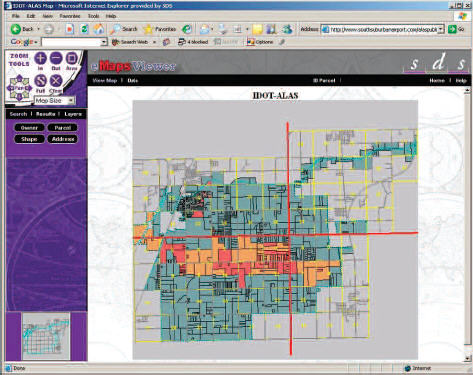
ILDOT: GIS Functionality in Large-Scale Land Acquisition for Public Use
In 2002, a site in Will County, Illinois was approved by the Federal Aviation Administration (FAA) to become the future home of the South Suburban Airport (SSA). Since they were a state-run airport, the Illinois Department of Transportation (ILDOT) would have the authority to purchase and acquire real property for the purpose of establishing and constructing the airport to benefit the public.
The airport design involved a site on 24,000 acres of land that consisted of roughly 1,200 residences, 100 farms and 20 businesses. The airport and its facilities would eventually displace all of these properties. In order to acquire the necessary land and provide relocation assistance to those residing in the affected area, a team of vendors was selected by ILDOT to begin the land acquisition process for the inaugural site.
Much of the project involved managing the land acquisition and land-use tasks associated with the creation of the new airport. Since the project involved real property transfers, additional tools became necessary. The project required a software system that could easily update, maintain and organize property ownership maps, legal documents and communications. Within the capabilities of the software, there was an additional need for status reporting that would make information available to not only the engaged parties, but also the public at large.
The Aeronautical Land Acquisition System (ALAS) was developed to aid in the decision-making process by integrating the tools needed to analyze the property data of areas being considered for the airport and related facilities. The system additionally provided real information that would assist ILDOT in their goal of continuously driving revenue through the land that had already been acquired. One example of this was the income produced from farmland that was still being cultivated during the acquisition process.
With the simultaneous occurrence of land selection, ownership transfer, acquisition and reporting, ILDOT needed complete accessibility along with project management and status monitoring capabilities. Where the use of standard project management software failed to accommodate the specific processes and format of land records effectively, the ALAS system succeeded. By incorporating document management, spatial analysis and real-time database viewing and editing, the progress of the entire project could be monitored effectively. With a clear, user-friendly interface, the software allowed users to easily identify and gather information about properties, as each parcel was color-coded to signify its acquisition or pending acquisition status and visually indicating the total project status.
"Without ALAS, I would not be able to keep track of all of the paperwork, status reports, financial and parcel information regarding this project,” noted Terry Tappenbeck, Chief of Land Acquisition for the ILDOT Division of Aeronautics. “With direct internet access to the system, I am able to answer inquiries quickly with up to date information without having to contact any contractors."
As a project of this magnitude includes diverse parties across a large area, a website was created to provide selected information to project contractors, managers and the public. To aid in the expedient delivery of status updates and required notifications, the software incorporated an automatic email notification system. By attaining high levels of mass public communication, the project won a Master Communicator Award.
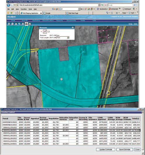
NDOT: GIS Functionality in Permitting and Permit Tracking
Following a significant audit of their right of way operations, the Nevada Department of Transportation (NDOT) identified the need for advancement in the management of their right of way information. To improve business processes for their engineering, utilities and permitting divisions, NDOT established specific objectives for the creation of their Integrated Right of Way Information Network (IRWIN) Permitting and Permit Tracking System. IRWIN was comprised of several components, including an Electronic Document Management System (EDMS), property inventory, property management and permit management including utilities and outdoor advertising.
The first objective of this multi-year, multi-phase project was the creation of an easy-access computing environment to provide property inventory information, utility agreements and encroachment permits to both the internal staff and the general public. The second objective focused on the property inventory, outlining the need for a management system that would support inventory, access, retrieval and management reporting of all right of way property. To improve service to their customers, the third objective was the development of a web-based system that allowed ILDOT uses customized tools to analyze property data for airport research, application requests, status tracking and fee payments.
NDOT recognized the need for a streamlined workflow and common interface solutions. The GIS-centric application that was selected works to simplify data integration and the transformation between databases, file systems of legacy systems using the latest collaboration and web technologies. The system is designed to take advantage of work done by the GIS section and to create a historical road network showing most of the system changes over time. This will allow users to perform queries and receive results for a specific place or time. Various documents and contract plans in the EDMS will then be linked with GIS to facilitate work processes. The EDMS portion alone is expected to save hundreds of man hours each year in right of way and other divisions that need access to contract plans. The system will also integrate with NDOT’s GIS/LRS, Public Lands Survey System data, video logging system, and their integrated financial system.
The system covers all facets of the right of way process, ranging from acquisition to property management permitting. With multi-user capabilities, the entire permit process can be tracked with standard reporting, customized reporting and ad hoc inquiry capabilities. A thorough and up-to-date status assessment can be provided with detailed date tracking from the initial funding estimate through the final certification, offering management the ability to track the entire process from the overall project status to the specific parcel level. In addition, repository capabilities allow the storage of transaction metadata to keep an audit trail of transactions that have been triggered and completed.
While the IRWIN system will allow NDOT to reach its internal goals, the largest achievement of this system will be seen ultimately in the benefits provided to NDOT customers. With the ability to monitor permits, applications and fee payment status, customers will have easier access to timely information. Enhanced research capabilities and a strengthened communication platform will allow questions, problems and resolutions to be expedited.
The Next Generation
As the application of GIS integration continues to expand, the transportation industry can expect to experience unlimited advancements and radical changes in efficiency and capability. With the needs of the industry identified, the evolution has begun with the collection of normalized, accurate data and the consolidation of that data into a standard, aggregate system.
GIS applications are now more accessible thanks to the increasing
availability of commercial-off-the-shelf (COTS) products, such as those
used by the DOTs in the case studies mentioned. The use of COTS
products reduces overall cost and accelerates the implementation time,
while increasing scalability and technical support. The convenience and
widespread use afforded by web-based applications further simplifies
the system updating process while simultaneously achieving large-scale
standardization and mass communication capabilities.
Previously, the parcel layer of data, which had always been particularly critical to the right of way process, was the most difficult data to obtain. Today, private companies are investing in the creation, collection and amassment of parcel data across the nation. The presence and increased accessibility of this data will have a profound impact on the transportation industry.
With the information collectively located and efficiently organized, the possibilities for extraction and analysis are boundless. The utilization of GIS integration will help streamline projects from the initial planning stages through the development phases. Agencies can make use of estimation tools, allowing thorough cost analysis based upon authentic, updated data. Timely reporting on a variety of factors and stipulations can be made quickly and accurately. The escalating role of GIS integration signals tremendous growth and remarkable possibilities for the future of the transportation industry.
With the growing demands imposed on our transportation infrastructure, state and local transportation agencies require capable, efficient solutions to enable them to resolve problems and make informed decisions with confidence. To meet these needs, transportation administrators increasingly depend on the unmatched potential of GIS and their ability to organize, display and facilitate complete analysis of vast amounts of information. Having digital parcel maps available with detailed property information just a mouse click away opens up the door to a whole new way of managing right of way projects.
Observing this trend and seeking to take advantage of the opportunities in GIS integration, the Transportation Research Board (TRB) began examining its potential in the right of way process by involving a panel of experts to monitor the research of current and future possibilities. As a division of the National Research Council, the board’s mission is to promote innovation and progress in transportation through research. The independent advisory group focuses on all modes of transportation, and provides an objective and interdisciplinary setting where it initiates and manages research projects in order to share information on transportation policy and programs. With support at both the federal and state level, the board widely disseminates the research results, offering expert advice while promoting technical excellence.
Recently, I had the distinct pleasure of chairing a TRB project panel that focused its efforts on future progress, specifically working to identify the problems and challenges presented within the right of way sector, and providing research funding to address these problems. While the panel’s findings confirmed the enormously valuable role of GIS within the realm of transportation, the research has also shown that few organizations have been able to fully capitalize on the potential of GIS integration. Like many concepts and processes rooted in technology, progress is often met with the initial challenges of hardware and software changes, system-wide standardization, and a need for education and training. With the rising rate of retirement within the industry, the evaporating knowledge pool makes the need for increased understanding even more vital. In some instances, a general shortage of knowledge regarding GIS capabilities makes the task of integration seem more complex and can unfairly outweigh the immense value, usefulness and functionality available.
Several difficulties may stand between a transportation agency and its successful use of GIS technology, including:
- Insufficient funding
- Complex multi-departmental organizations
- Disconnected systems or “stovepipe” systems
- Evaporating knowledge pool
- Lack of data integrity and standardization
- Lack of trained GIS resources
WSDOT: Modernization of the Right of Way Management System
In reviewing their real estate services program, the Washington State Department of Transportation (WSDOT) identified a great need for a more modern and efficient right of way management system. Facing state and federal mandates, along with ever-increasing requests for information, WSDOT needed to improve their data integrity and
consolidate it into a well-organized system that would allow special reporting and ad hoc inquiries.
Previously, WSDOT was using an internally developed system, and as a result, did not benefit from any vendor support or program scalability. Their system lacked GIS integration and automated processes, and failed to provide timely information in a user-friendly format. With six regional offices and multiple remote offices all operating independently, inconsistency across the agency was becoming a major hurdle. In order to identify and document the current needs and obstacles, a Business Process Reengineering (BPR) phase was completed. The goal of the BPR was to assess the efficiency and effectiveness of the existing workflow processes and identify areas for improvement. By incorporating the BPR at this stage, the department and their vendors could look at the business processes from a “clean slate” perspective and determine how to best impact and improve how they conduct business.
 |
As with many departments of transportation, the need for accessibility among a large base of users is essential. For WSDOT, this involved providing easy access for approximately 150 users across the state. It was obvious that a web-based platform was necessary to utilize the latest technologies while eliminating the complications of potential software updates in a multi-departmental system. With this increased accessibility, they were able to simplify the dissemination of guidelines and standard practices for all state agencies involved in the real estate activities.
In the next phase of the IRIS project, WSDOT will be evaluating the feasibility of GIS integration to further advance their capabilities. The addition of GIS will provide WSDOT with complete project management capabilities, enabling them to easily locate properties affected by an acquisition and display them on a map for estimation. With detailed parcel data, document linking and right of way buffering, advanced cost estimations may be performed.
ILDOT: GIS Functionality in Large-Scale Land Acquisition for Public Use
In 2002, a site in Will County, Illinois was approved by the Federal Aviation Administration (FAA) to become the future home of the South Suburban Airport (SSA). Since they were a state-run airport, the Illinois Department of Transportation (ILDOT) would have the authority to purchase and acquire real property for the purpose of establishing and constructing the airport to benefit the public.
The airport design involved a site on 24,000 acres of land that consisted of roughly 1,200 residences, 100 farms and 20 businesses. The airport and its facilities would eventually displace all of these properties. In order to acquire the necessary land and provide relocation assistance to those residing in the affected area, a team of vendors was selected by ILDOT to begin the land acquisition process for the inaugural site.
 |
Much of the project involved managing the land acquisition and land-use tasks associated with the creation of the new airport. Since the project involved real property transfers, additional tools became necessary. The project required a software system that could easily update, maintain and organize property ownership maps, legal documents and communications. Within the capabilities of the software, there was an additional need for status reporting that would make information available to not only the engaged parties, but also the public at large.
The Aeronautical Land Acquisition System (ALAS) was developed to aid in the decision-making process by integrating the tools needed to analyze the property data of areas being considered for the airport and related facilities. The system additionally provided real information that would assist ILDOT in their goal of continuously driving revenue through the land that had already been acquired. One example of this was the income produced from farmland that was still being cultivated during the acquisition process.
With the simultaneous occurrence of land selection, ownership transfer, acquisition and reporting, ILDOT needed complete accessibility along with project management and status monitoring capabilities. Where the use of standard project management software failed to accommodate the specific processes and format of land records effectively, the ALAS system succeeded. By incorporating document management, spatial analysis and real-time database viewing and editing, the progress of the entire project could be monitored effectively. With a clear, user-friendly interface, the software allowed users to easily identify and gather information about properties, as each parcel was color-coded to signify its acquisition or pending acquisition status and visually indicating the total project status.
"Without ALAS, I would not be able to keep track of all of the paperwork, status reports, financial and parcel information regarding this project,” noted Terry Tappenbeck, Chief of Land Acquisition for the ILDOT Division of Aeronautics. “With direct internet access to the system, I am able to answer inquiries quickly with up to date information without having to contact any contractors."
As a project of this magnitude includes diverse parties across a large area, a website was created to provide selected information to project contractors, managers and the public. To aid in the expedient delivery of status updates and required notifications, the software incorporated an automatic email notification system. By attaining high levels of mass public communication, the project won a Master Communicator Award.
NDOT: GIS Functionality in Permitting and Permit Tracking
Following a significant audit of their right of way operations, the Nevada Department of Transportation (NDOT) identified the need for advancement in the management of their right of way information. To improve business processes for their engineering, utilities and permitting divisions, NDOT established specific objectives for the creation of their Integrated Right of Way Information Network (IRWIN) Permitting and Permit Tracking System. IRWIN was comprised of several components, including an Electronic Document Management System (EDMS), property inventory, property management and permit management including utilities and outdoor advertising.
The first objective of this multi-year, multi-phase project was the creation of an easy-access computing environment to provide property inventory information, utility agreements and encroachment permits to both the internal staff and the general public. The second objective focused on the property inventory, outlining the need for a management system that would support inventory, access, retrieval and management reporting of all right of way property. To improve service to their customers, the third objective was the development of a web-based system that allowed ILDOT uses customized tools to analyze property data for airport research, application requests, status tracking and fee payments.
NDOT recognized the need for a streamlined workflow and common interface solutions. The GIS-centric application that was selected works to simplify data integration and the transformation between databases, file systems of legacy systems using the latest collaboration and web technologies. The system is designed to take advantage of work done by the GIS section and to create a historical road network showing most of the system changes over time. This will allow users to perform queries and receive results for a specific place or time. Various documents and contract plans in the EDMS will then be linked with GIS to facilitate work processes. The EDMS portion alone is expected to save hundreds of man hours each year in right of way and other divisions that need access to contract plans. The system will also integrate with NDOT’s GIS/LRS, Public Lands Survey System data, video logging system, and their integrated financial system.
The system covers all facets of the right of way process, ranging from acquisition to property management permitting. With multi-user capabilities, the entire permit process can be tracked with standard reporting, customized reporting and ad hoc inquiry capabilities. A thorough and up-to-date status assessment can be provided with detailed date tracking from the initial funding estimate through the final certification, offering management the ability to track the entire process from the overall project status to the specific parcel level. In addition, repository capabilities allow the storage of transaction metadata to keep an audit trail of transactions that have been triggered and completed.
While the IRWIN system will allow NDOT to reach its internal goals, the largest achievement of this system will be seen ultimately in the benefits provided to NDOT customers. With the ability to monitor permits, applications and fee payment status, customers will have easier access to timely information. Enhanced research capabilities and a strengthened communication platform will allow questions, problems and resolutions to be expedited.
The Next Generation
As the application of GIS integration continues to expand, the transportation industry can expect to experience unlimited advancements and radical changes in efficiency and capability. With the needs of the industry identified, the evolution has begun with the collection of normalized, accurate data and the consolidation of that data into a standard, aggregate system.
 |
Previously, the parcel layer of data, which had always been particularly critical to the right of way process, was the most difficult data to obtain. Today, private companies are investing in the creation, collection and amassment of parcel data across the nation. The presence and increased accessibility of this data will have a profound impact on the transportation industry.
With the information collectively located and efficiently organized, the possibilities for extraction and analysis are boundless. The utilization of GIS integration will help streamline projects from the initial planning stages through the development phases. Agencies can make use of estimation tools, allowing thorough cost analysis based upon authentic, updated data. Timely reporting on a variety of factors and stipulations can be made quickly and accurately. The escalating role of GIS integration signals tremendous growth and remarkable possibilities for the future of the transportation industry.
From Our Homepage
Saying Farewell to an Amazing Journey
Communicating with Maps
Is There a GIS Career Ladder?
What does it mean to be geospatially smart? Series
Ways Real Estate and Property Developers Utilize Melissa GeoData for Data-Driven Decisions
Unlocking Value From Daily Satellite Imagery and Insights
Maximizing the Value of Your Address Data with Geo Addressing
How Indoor Mapping Enhances the Security of Smart Buildings
Look Ahead: AI, Location Intelligence and Efficiency
Collaboration Takes on Sea Level Rise & Dynamic Technology Environments
Brownies for Brownfields
Has Everything Been Mapped Already?
How Is Data Literacy Changing in an Artificial Intelligence Landscape
Portfolios for GIS Professionals: More Than Just Maps
How to Create a Distance Matrix in QGIS - A Step-by-Step Guide
7 Ideas for Bringing GIS into the K-12 Classroom
The Geography of Movement