 As many
of us add an
attribute or extend a feature to some
map of existing geographies, in a place that we commute to every day,
there is
a group of people who do something while similar, can be far different
in the
use and application of GIS.
As many
of us add an
attribute or extend a feature to some
map of existing geographies, in a place that we commute to every day,
there is
a group of people who do something while similar, can be far different
in the
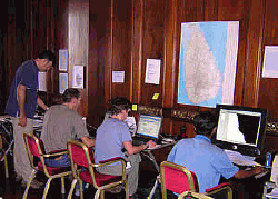
use and application of GIS.With minimal notice, they leave their comfortable heated and air conditioned GIS environments for someplace in the world which may have neither.Power is intermittent at best, data may be limited or almost non-existent and critical map production is derived from their laptops and portable printers and whatever current imagery is available.From Asia, to the Middle East, to Africa, wherever there is a disaster, you may find the volunteers from MapAction.
Directions Magazine has been extremely fortunate to obtain an interview via email with Nigel Woof, the MapAction Operations Manager, Sri Lanka, about their support to the Tsunami relief effort.A diary of their efforts from deployment in late December 2004 to their last day on site can be found here.
Hal Reid (HR): MapAction, by it's own definition, "supports (International) humanitarian operations with real time mapping," and is staffed by GIS volunteers.Can you give me an idea of just who these people are, and their backgrounds? In other words, what do they do for their "day job?"
Nigel Woof (NW): Most of our team works in applied GIS fields.Their employers include the British Antarctic Survey, GIS software suppliers including ESRI, the UK Environment Agency and the British Ordnance Survey (national mapping agency).Two teach GIS at universities and one is completing a PhD on flood mapping.Two work for geo-information solutions companies: Infoterra Ltd.and NPA Group respectively.
HR: If the situation requires a deployment longer than a few days to a week, how deep is your pool of volunteers to be able to maintain a viable presence over a longer period?
NW: At present we have just over twenty "deployable" volunteers available for short-duration missions and more are due to enter training soon.Our operating model is focused on supporting the crucial "search and rescue" and initial relief phases of a sudden-onset disaster.This typically has a time frame of a week to ten days.After that time we would hand over to local GIS resources if present (as we have done in Sri Lanka).In other cases the UN would, within a few weeks, deploy a Humanitarian Information Centre (HIC) which includes a GIS capability.Also in Sri Lanka we have rotated volunteers, which has allowed us to maintain a presence there for over three weeks.
HR: I noticed on your web site that you have trained using disaster simulations, and certainly you have extensive real world experience in applying GIS to previous humanitarian operations.Now that you are knee deep in this current event in Asia, considering it's scope and magnitude, how do you prepare for all the disaster possibilities, and what other training might have been of value?
NW: Disaster management experts, such as the United Nations Disaster Assessment and Coordination (UNDAC) team, will tell you that every disaster is unique and lessons learned in one can't always be applied more broadly.The Asian tsunami is characterized by its geographical scale (compared, say to an earthquake affecting a single city or region).The most important training values are therefore flexibility and operational resilience.Disaster simulations (such as the UN Triplex exercises) give invaluable practice in working closely with other agencies.The Sri Lanka operation hasn't uncovered any serious training deficiencies, however we will be continuing to focus on cross-skilling of our team to maximize flexibility in the field in future projects.
HR: What software, standard data sets and hardware makes up your typical deployment? Does this consist of multiple platforms and operating systems?
NW: There are no standard data sets although we would normally aim to deploy with at least the relevant Landsat imagery which we can obtain from archive sources at short notice - we unzipped and loaded the data and prepared base maps on the plane this time.
We currently use ESRI software, ArcGIS 9.0, though we are reviewing this.We don't make full use of its functionality and in fact the GIS software needs on an operation are fairly straightforward.Our hardware is based on notebook PCs (currently Dells although we are reviewing this also). Operating systems have been standardized on Windows XP Professional.
Our field equipment includes Garmin MAP76 GPS receivers which are robust and provide a useful combination of simple operation with sufficient storage for most applications.We have run trials using ArcPad on handheld computers for field data capture.This is suitable for some situations although the technology is still 'fragile' and less flexible than 'traditional' methods in emergency situations where it's hard to predict what kinds of information you will need to capture until you arrive on the spot.
As part of MapAction's expansion and capability development, we are considering setting up a permanent UK base with a server centre and through this to use ArcSDE for the storage and retrieval of large datasets and ArcIMS as part of the data dissemination that is key to the success of MapAction.
Printing in the field is the biggest headache; it's hard to find lightweight, fast and reliable A3 printers.
HR: Your initial presence in an area and the production of maps to identify key areas of risk, need, support and focus requires people in the field using GPS and PDAs.With communications usually among the first services to go, how do you get information back from the field and into map production, when communication is spotty at best?
NW: Several ways:
(a) VHF radio.We deploy with our own base station and portables.Good for local area work, e.g.around a single disaster site.Voice only, but key information can be relayed back by this means, with coordinated read out over the air.All our people are trained in UN-standard radio voice procedure.
(b) HF radio.We don't have this but will often be moving around with UN or other assessment teams with an HF capability, which we can use.
(c) Satellite voice comms.We have Thuraya hand held units and can call on other systems for locations not covered.We have also developed a system for uploading large quantities of data to a fieldbase using a PDA linked to Thuraya.
(d) For fieldbase to the outside world (uploading maps and shapefiles) we use a BGAN satellite modem.If we had the luxury of a broadband landline internet connection we would of course use that.
HR: It seems that there is a lot of reliance upon the internet and FTP servers for the distribution of the maps you create on site.It is easy to imagine situations where access to the internet is more than a little difficult.Can you tell me about the other infrastructure you bring with you to assist in the distribution of the maps you create?
NW: During the Sri Lanka operation we realized that FTP servers are not the best way to distribute maps to users, because (a) the interface isn't user-friendly, (b) many people are scared off by an unfamiliar internet format, and (c) giving people access allows them potential to write or delete files - obviously not ideal.So, we quickly arranged for our maps to be web-published on our own website.The specialists in map republishing - Alertnet (Reuters Foundation) and Reliefweb (UN-OCHA) did not prove effective distribution channels for our maps, and we will be entering a dialogue with these organizations to find out what can be learned and improved.
During past exercises we have relied much more on paper distribution of maps.With the huge geographical spread of relief organizations in this disaster, electronic distribution had a much more prominent role.Many of the relief organization also use BGAN satellite modems, so we can reasonably rely on others being able to access our maps via the internet.
HR: While humanitarian operations are not restricted by geography, the nature of viable data is.Some areas having extensive and accurate map files and data and others something a whole lot less.How do you deal with incomplete and inaccurate data and what resources do you bring with you so you can provide viable maps?
NW: Some areas may have vector data available digitally but we may have to consider digitizing from paper maps in the field...not an exact science but we aren't looking for cartographic perfection! We will always have access to medium-resolution satellite imagery such as Landsat, which can provide a good base layer for situational mapping in some terrains.A good way to add route layers is to drive the roads with a GPS and use the tracklog as the road overlay.We waypoint key changes in condition (e.g.surfaced to gravel) so we can attribute each section appropriately.This was not of course necessary in Sri Lanka where good vector data exists.
A 'viable' map can in fact be very simple.If you look on our website you will find a photo of a hand drawn sketch map of Bam, which was used to plan the search and rescue after the earthquake there in 2003. During a recent training exercise with rescue workers in November, one of the first maps we produced (in the first hour of the exercise) was simply an archived Quickbird image, overlaid with graticules, to allow them to use their GPSs to locate themselves on the image.Although simple in terms of the GIS involved, this was considered to be a big improvement on want they had made do with previously.
HR: In spite of the difficulties in logistics, communications, basic infrastructure and available map data, I sense that because of your organization and experience that you have it pretty well together when you get a call to respond.In spite of planning a preparation, what is the one frustration that seems to be unavoidable?
NW: The biggest issue is that of uncertainty in the first 24 hours of a disaster. In that time we have to decide whether to deploy, with how many people, and by what means.Getting people and equipment to the scene may be difficult, especially if the affected country has not by that stage asked formally for foreign assistance - visas etc may therefore need to be applied for.In other respects our team should be ready to go - we all maintain a "bags packed" stance as soon as news of a disaster is received, and of course all the basics like inoculations are covered under our readiness standards.
HR: I suspect you have made a lot of the GIS professionals that read Directions Magazine very envious of what you do and they probably wish could be in your shoes.Is there anything you would like to say to them in terms of how they might be participants in future humanitarian efforts?
NW: MapAction is at present UK-based only so volunteers need to live here or be prepared to travel here regularly for training (one of out team lives in Paris).Prospective team members should be mature individuals (typically team members are in their thirties).In addition to well rounded GIS skills they should possess plenty of "life experience" including traveling or living overseas.They must be in a position to attend at least 10 training days or weekends per year and of course be available for deployment at short notice when required - maybe once a year for one or two weeks.But we don't expect anyone to guarantee their availability at all times.Most important of all is to be a team player who can function with reliability and good humour in stressful and tiring conditions...neither shrinking violets nor prima donnas need apply!
(Ed. Note: Although this interview didn't specifically cover the area of donations, we would encourage readers to make donations to MapAction and/or any of the other organizations involved in this relief effort.In addition, if you don't live in or near the UK and would like to be involved in a GIS-related volunteer organization, check out GIS Corps.)
From Our Homepage
Saying Farewell to an Amazing Journey
Communicating with Maps
Is There a GIS Career Ladder?
What does it mean to be geospatially smart? Series
Ways Real Estate and Property Developers Utilize Melissa GeoData for Data-Driven Decisions
Unlocking Value From Daily Satellite Imagery and Insights
Maximizing the Value of Your Address Data with Geo Addressing
How Indoor Mapping Enhances the Security of Smart Buildings
Look Ahead: AI, Location Intelligence and Efficiency
Collaboration Takes on Sea Level Rise & Dynamic Technology Environments
Brownies for Brownfields
Has Everything Been Mapped Already?
How Is Data Literacy Changing in an Artificial Intelligence Landscape
Portfolios for GIS Professionals: More Than Just Maps
How to Create a Distance Matrix in QGIS - A Step-by-Step Guide
7 Ideas for Bringing GIS into the K-12 Classroom
The Geography of Movement