It is believed by many in the value chain that LBS adoption rates and its capability to achieve a significant percentage of carrier business goals is challenged by the disparate location technology implemented by carriers, service providers and equipment vendors. In particular, the question of how wireless carriers and service providers will implement and utilize their different location infrastructures is a question with many answers. As a result, the LBS community will most likely be faced with having to support multiple, disparate location-determining technologies (LDT), a plethora of geo-spatial and content implementations, and multiple data transport protocols. Doing this is simply cost prohibitive.
The key to navigating this location
interoperability landscape will be the development and adoption of a ubiquitous
set of interconnected wireless communications and Internet location service
standards. These standards will be the road map for the definition
of an industry and its customer driven deployment of mass market services
and content by carriers and Internet service suppliers like AOL, Microsoft,
and even member organizations such as AAA. The status of the major
standards groups leading this charge is the focus of this article.
Hydra of Location Standards
A multitude of standards organizations such as the Internet Engineering Task Force (IETF) and The World Wide Web Consortium (WC3) have location and geo-spatial initiatives, working groups and published specifications, yet location is not their core focus. In addition, many of these large organizations have slowed adoption of location-specific standards as a result of organizational member's unwillingness to support standards, which may not support their business strategies.
To offset this lack of "location focus" on both the wireless and Internet fronts, two well-positioned organizations have emerged as the drivers of location interoperability: LIF (Location Inter-Operability Forum - www.locationforum.org) and OGC (Open GIS Consortium - www.opengis.org). Both OGC and LIF are seen as the standard bearers for pro-actively championing the wireless location interoperability challenge. These two organizations are accomplishing this monumental task through a cooperative strategy of working with other standards bodies to promote a cohesive set of wireless location interoperability standards. "LIF's formation was in part due to the inability of other standards bodies to develop location standards rapidly," states Dr.Dan Greening, CEO of BigTribe and chair of LIF's Standards Influencing Group.
Are two organizations one too many when it comes to the adoption of industry-wide standards? Logic would dictate that developing a single cohesive standard would be best served by a single organization leading the charge. When it comes to the convergence of wireless, the Internet and location, however, two organizations are better than one for ensuring the adoption and utilization of location standards. Two organizations supporting the standards will help drive mass-market adoption of location-centric services and technologies.
The Standard Bearers
The OpenLS Initiative (www.openls.org) a test bed initiative to rapidly engineer Location Services (LS) application interfaces, championed by OGC is designed to support interoperable solutions that "geo-enable" the Internet, wireless and location-based services, and mainstream IT. These solutions empower technology developers to make complex spatial information and services accessible and useful with all kinds of applications. "OGC's OpenLS Initiative is not about maps", states Louis Hecht, Vice President of Business Development for OpenGIS Consortium, "OGC's goal is to extend the GIS environment into the everyday lives of telecommunications users." OGC boasts over 230 members worldwide including Oracle, Sun Microsystems, ESRI, Hutchison 3G UK, MapInfo, and Vodafone to name a few.
The Location Interoperability Forum (LIF), on the other hand, focuses efforts on the wireless side of the LBS market. "LIF focuses first on how location middleware fits into the wireless network, specifying uniform interfaces for vendors and network providers," comments Dan Greening, "but LIF also provides application interfaces." LIF has developed (and continues to refine) the Mobile Location Protocol (MLP) standard for utilization by carriers, wireless infrastructure providers and mobile application developers. These members work within LIF to develop standards and protocols for seamlessly integrating location with the mobile user experience. LIF boasts over 140 members, including Ericsson, Motorola, Nokia, Siemens, SignalSoft, and Autodesk. In addition, LIF has agreements with other organizations such as 3rd Generation Partnership Project (3GPP - www.3gpp.org) and WAP Forum (WAPF - www.wapforum.org).
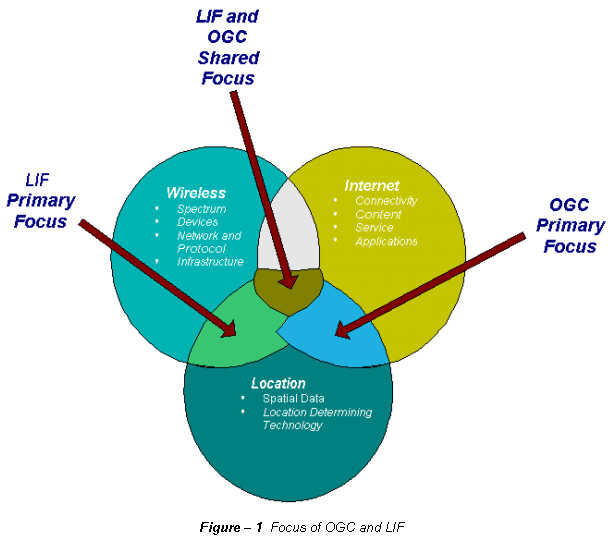
Figure - 1 Focus of OGC and LIF
All in the Family
Both LIF and OGC share at least 12 common members who have interests in both the wireless and Internet arenas of location technology, LBS and GIS. Companies such as MapInfo and AutoDesk each have their own view of the market and participate in LIF and OGC in different ways to ensure their business and technology interests are properly represented throughout the various standards bodies.
For LIF, OGC and other standards bodies, having common members is not detrimental to the organization's efforts. Common members provide continuity across the standards bodies and various working groups, furthering a ubiquitous set of standards throughout various market and technology sectors.
Vodafone is a good example of one of the common members. Interoperability of equipment via open standards and open interfaces is a key part of Vodafone Group's strategy to launch location services worldwide.Working with both LIF and OGC, Vodafone has been able to influence the common set of interfaces for utilization by various network vendors and ASP providers. On the mobile side, this is complementary to Vodafone's global reach and is technically necessary to support regional and even global roaming implementations of wireless services. On the Internet and Geo-spatial side, Vodafone is influencing standards development, which will allow content services from various regional and localized sources to be seamlessly incorporated into Vodafone's location-specific offerings.
Golden Spike of Interoperability
Like the golden spike completing the first transcontinental railroad in 1869, interoperability between LIF and OGC standards is critical when it comes to the convergence of location technologies and the widespread adoption of end-to-end solutions for LBS. Like the Union Pacific and Central Pacific railroads, the LIF and OGC work closely to ensure that the Internet and wireless standards driven by either organization are mutually supported (Figure - 2). As a result, the roles of both LIF and OGC are so intertwined that OGC is actually a member of the LIF organization. OGC works closely within the LIF organization to ensure, for example, that the LIF Document Type Definition (DTD) and OpenLS XML schemes work in harmony, allowing content transmission between LIF and Open LS based software without the loss of information and minimal or no translation. This is critical to supporting the wireless to Internet interchange of location-specific content and service support.
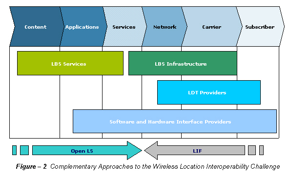
Figure - 2 Complementary
Approaches to the Wireless Location Interoperability Challenge
OGC Focus
OGC's focus is on the application,
data and presentation layers of the Internet stack. "OGC is not concerned
with the application code hidden between the layers. This is and
will always remain the intellectual property of the specific vendor," says
Louis Hecht.To this end, OGC responds to the LBS market and location-centric
issues which impact the industry as a whole, not just individual companies.
One example of this market-wide focus is the development of a consensus
and agreement on the technical details of open interface standards supporting
interoperability at the application layer within the Internet stack.

Figure - 3 OGC Focus on Internet Interoperability
In the LBS space, OGC accomplishes this through the development of several proof-of-concept demonstration versions of its interoperable OpenLS GeoMobility Server architecture utilizing multiple vendors, applications and devices. The GeoMobility Server is an open location services platform though which service providers can deliver and service location-centric applications and content from any device or service provider.
In addition, OGC actively promotes the OpenLS standards through global forums at which corporations and individuals can become more informed and educated about OpenLS and OGC interfaces being adopted throughout the industry. As Louis Hecht commented on OGC efforts, "OpenLS supports increased synergy within the major commercial standards that exist today which are required to bring LBS to end user customers."
LIF Focus
LIF approaches location interoperability from the wireless network viewpoint, which has no shortage of unresolved issues (see Figure - 4 below). To address these challenges, LIF focuses on standardizing the approach to address the growing concern of location-centric barriers to wireless interoperability. By introducing the Mobile Location Protocol (MLP) standard, which is concerned with the integration of position or location in the carrier communications environment, LIF has been able to focus its efforts on a single industry-wide capability to handle the location from either a Mobile Positioning Center (MPC) or Gateway Mobile Location Center (GMLC).
Privacy and roaming are just two examples of challenges facing handset manufacturers, network infrastructure providers and services providers in the wireless industry. Privacy is further compounded when location is involved. In particular, issues arise concerning the tagging of data with service or transactional information associated with a subscriber's location data. As Dan Greening described the delicate subject of privacy, "Privacy and security are critical to the success of location services.Only user-authorized services and intermediaries should be able to view location data, and only in response to a request from an authenticated end user or application."
Roaming, on the other hand, has unique technology and political challenges when a subscriber roams across boundaries within interconnected wireless networks.In addition to billing, service continuity and hand-off issues, roaming, when combined with location adds another unique challenge - localization of data content. Vendors in the LBS market who support a carrier's location services have to figure out how to seamlessly provide location content utilizing regional data formats. One such example is the disparate number of local coordinate systems being utilized across the GSM networks in Europe and Asia. Suddenly one vendor can be faced with content in multiple formats for the same data set. This is where LIF comes into play - by providing a forum and championing a standard for addressing these multiple and cross-boundary implementation challenges.
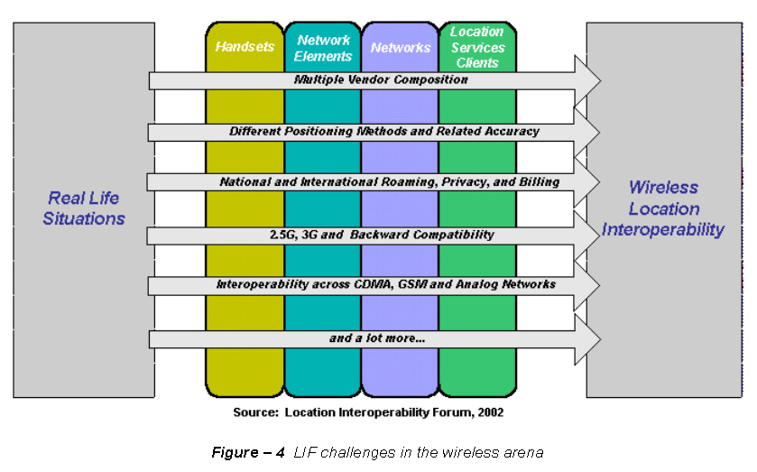
Figure - 4 LIF challenges
in the wireless arena
Two Perspectives -- One Focus
As expected, there is considerable overlap between LIF and OGC concerning wireless location interoperability. This overlap provides for expanded awareness and adoption of the combined standards. For example, LIF has incorporated the location requirements of 3GPP, thus furthering a more uniform set of standards across multiple organizations and "adjacent" industries. Even between OGC and LIF, there is mutual support for a single set of location interoperability standards. OpenLS, for example, will include the MLP by reference (e.g.providing a better understanding on how to access LIF standards). This is, in effect, an endorsement by OGC of LIF's standard, resulting in a more focused effort by the industry behind location interoperability.
Success in Standards
So why is there a need for a focused effort concerning wireless location interoperability? The answer is found in the multi-layered nature of the LBS industry responsible for developing, operating, and supporting the Location Services Value Chain: There are over 300 companies in the LBS market worldwide, yet no definition of fundamental service architecture to support location services. Combine this with the high cost and commitment of integration across disparate technologies and carrier implementations; many of these companies have neither the resources nor the stamina to take on LBS in such a hostile environment.
The standards being championed by LIF and OGC ensure the smooth flow of information between content repositories, the Internet and end-user devices through open protocols. One of the industries that will benefit from LBS standards is telematics. At the Telematics 2002 show in Detroit, Jim McHenry of Verizon Wireless commented during his presentation that standards are necessary for telematics to be successful and move beyond the luxury car implementations. Without standards, telematics will continue to remain a niche LBS implementation.
In addition, standards support interoperability,
which results in wireless carriers potentially deploying LBS infrastructure
faster - e.g.commercial utilization of E9-1-1 infrastructure when it does
finally come online in the U.S. As a result, standards will provide
application and content providers with a ubiquitous contextual meaning
to location, regardless of the LDT utilized.
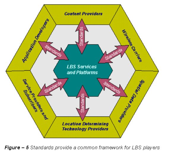
Figure - 5 Standards provide
a common framework for LBS players
Enemy at the Gateway
The efforts of LIF and OGC in promoting interoperability standards are not immune to criticism or opposition. One of the most immediate challenges to adoption of standards is market inhabitation due to individual company's proprietary interfaces. At what level is standardization required, and at what level is the technology implementation left up to the vendors? There needs to be room for those "killer applications" or "killer implementations." Combined with the disparate wireless, LDT, Internet and GIS systems, the ubiquitous wireless location interoperability standard is still a long way off from industry-wide adoption. But without standards, there can be no end-to-end location implementation utilizing the best-in-class technologies.
And let us not forget the end users - e.g.everyone's customer. Wireless users are not concerned with the underlying architecture or technologies powering their phones or voice and data services. Location information by itself has no value to them. Instead, these customers will welcome the use of wireless location technologies in their everyday lives, provided that it is as mobile and ubiquitous as their lifestyles, and that it protects their privacy. The only way for the LBS industry to meet this challenge is if it works together through the development and adoption of location wireless interoperability standards.
Jim
VanderMeer is a product director at Airbiquity
Inc. Airbiquity is a location technology company that delivers
global positioning system (GPS) data to any wireless network worldwide.
The company's patented aqLink™ software enables wireless carriers, automobile
manufacturers, commercial call centers and Internet portals to offer their
subscribers location-based services that enhance productivity, manage assets,
and deliver personalized content.