UPDATE - October 28, 2003 (From NASA's Earth Observatory)
Whipped by the hot, dry Santa Ana winds that blow toward the coast from interior deserts, at least one fire grew 10,000 acres in just 6 hours. (Compare this scene with one captured by Aqua MODIS just one day before.) The Moderate Resolution Imaging Spectroradiometer (MODIS) on the Terra satellite captured this image of the fires and clouds of smoke spread over the region on October 26, 2003.(Image courtesy Jacques Descloitres, MODIS Rapid Response Team at NASA GSFC)

(Click on image for higher resolution image)
October 27, 2003 -- From the U.S.Department o f Commerce, National Oceanographic and Atmospheric Administration - Oct.27, 2003 - Wildfires burning for days merged into walls of flame stretching for miles across parts of Southern California on Sunday causing death and destruction.Air travel has been disrupted across the nation.Over the weekend, more than 7,000 firefighters fought ten major fires in southern California, one large cluster in the San Diego area and another about 100 miles north in mountainous areas north of Los Angeles.More than 300,000 acres have been blackened by the raging blazes.The fire storms drew much of their strength from the fierce Santa Ana winds, with near-hurricane gusts of up to 70 mph. Fires remain out of control as firefighters concentrate on evacuating residents and protecting structures. 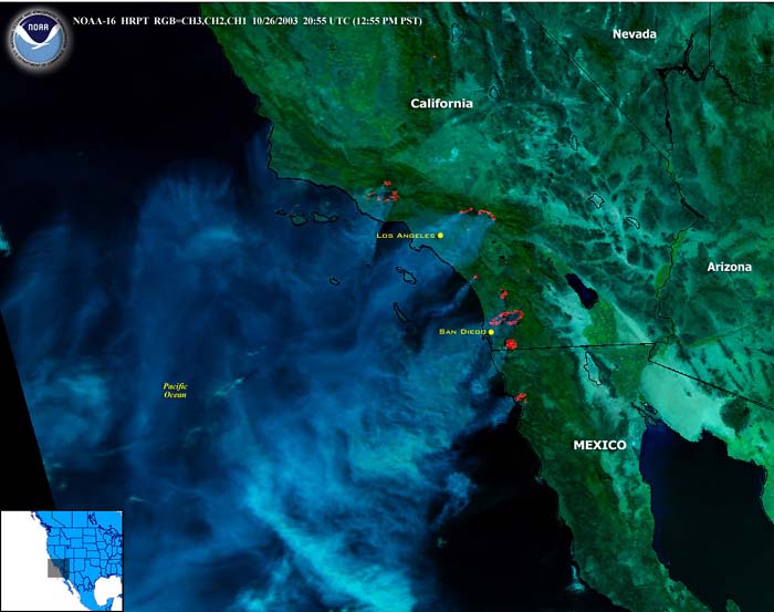
The image was taken by the NOAA-16 National Polar-orbiting Operational Environmental Satellite (NPOESS) on 26 Oct 2003 at 20:55 UTC.NPOESS will collect and disseminate data about the Earth's oceans, atmosphere, land, climate, and space environment.These environmental measurements are made available by a variety of instruments (sensors) both new and existing, including the VIIRS, Visible/Infrared Imager/Radiometer Suite housing the Advanced Very High Resolution Radiometer (AVHRR).
(Source: NOAA)