Editor's note: Back in March, Glenn Brooks,
Mercy Corps'
Geographic Information Officer shared
the vision for what his team hoped to accomplish both "in country"
and in the Pacific Northwest.He shares this update.
We are at an interesting milestone at the moment.Officially our funding and participation with Mercy Corps ends July 31st.So far we have not heard word whether or if funding will be continued.Certainly this will be resolved by the end of the month.
There continues to be considerable GIS community interest in organizing a permanent volunteer GIS emergency response team organization here in the Pacific North West (PNW).We have received considerable vendor and user group support to continue organizing humanitarian GIS activity around this model - really geospatial activity including GIS, GPS work and remote sensing - and hope to reach some consensus on organization and scope of work by end of August.(The summer months turn the PNW into a ghost town, so organizing a meeting with more than one person is problematic!!)
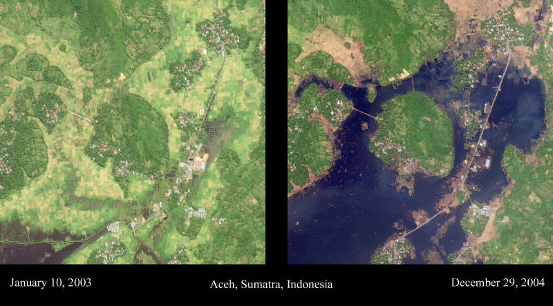
We continue to have two 90 day GIS field programs still underway, one each in Sri Lanka and Northern Sumatra, and are conducting a mangrove assessment remote sensing project in the Seattle Data Center.One team with two people in Sumatra may extend its contract for a month or so to finish an ongoing database development project.Within the past three months we hosted three groups of University of Washington (UW) graduate students engaged in researching GIS deployment in humanitarian affairs and also partnered with UW student volunteers to recreate a tsunami physical impact GIS data set of destroyed aquaculture ponds and housing locations in a village near Aceh in Sumatra.This work was accomplished by digitizing preexisting infrastructure of the village and shrimp pond areas using high resolution QuickBird satellite imagery acquired during our imagery processing project with the Pacific Disaster Center.
Using the same methodology, our Data Center GIS people are now involved in digitizing the full Tsunami-altered Sumatra coastline from Melouba to Banda Aceh, a distance of 200 km, or about 120-140 miles.(There is some nice animated imagery that illustrates the change in the coast at Global Security.org.- Ed.)
The US Corp of Engineers and US Navy assessment teams documented some
post-event video showing some lowland coastline along Sumatra's west
coast, closest to the earthquake epicenter, as receding up to 1/2 mile
inland because of tsunami wave erosion.Massive vegetation scouring is
quite noticeable in most of our satellite imagery, so we are using this
high impact zonal area to define the new extant coastline.
We are at an interesting milestone at the moment.Officially our funding and participation with Mercy Corps ends July 31st.So far we have not heard word whether or if funding will be continued.Certainly this will be resolved by the end of the month.
There continues to be considerable GIS community interest in organizing a permanent volunteer GIS emergency response team organization here in the Pacific North West (PNW).We have received considerable vendor and user group support to continue organizing humanitarian GIS activity around this model - really geospatial activity including GIS, GPS work and remote sensing - and hope to reach some consensus on organization and scope of work by end of August.(The summer months turn the PNW into a ghost town, so organizing a meeting with more than one person is problematic!!)
We continue to have two 90 day GIS field programs still underway, one each in Sri Lanka and Northern Sumatra, and are conducting a mangrove assessment remote sensing project in the Seattle Data Center.One team with two people in Sumatra may extend its contract for a month or so to finish an ongoing database development project.Within the past three months we hosted three groups of University of Washington (UW) graduate students engaged in researching GIS deployment in humanitarian affairs and also partnered with UW student volunteers to recreate a tsunami physical impact GIS data set of destroyed aquaculture ponds and housing locations in a village near Aceh in Sumatra.This work was accomplished by digitizing preexisting infrastructure of the village and shrimp pond areas using high resolution QuickBird satellite imagery acquired during our imagery processing project with the Pacific Disaster Center.
Using the same methodology, our Data Center GIS people are now involved in digitizing the full Tsunami-altered Sumatra coastline from Melouba to Banda Aceh, a distance of 200 km, or about 120-140 miles.(There is some nice animated imagery that illustrates the change in the coast at Global Security.org.- Ed.)
 |
From Our Homepage
Saying Farewell to an Amazing Journey
Communicating with Maps
Is There a GIS Career Ladder?
What does it mean to be geospatially smart? Series
Ways Real Estate and Property Developers Utilize Melissa GeoData for Data-Driven Decisions
Unlocking Value From Daily Satellite Imagery and Insights
Maximizing the Value of Your Address Data with Geo Addressing
How Indoor Mapping Enhances the Security of Smart Buildings
Look Ahead: AI, Location Intelligence and Efficiency
Collaboration Takes on Sea Level Rise & Dynamic Technology Environments
Brownies for Brownfields
Has Everything Been Mapped Already?
How Is Data Literacy Changing in an Artificial Intelligence Landscape
Portfolios for GIS Professionals: More Than Just Maps
How to Create a Distance Matrix in QGIS - A Step-by-Step Guide
7 Ideas for Bringing GIS into the K-12 Classroom
The Geography of Movement